Spring 8 part 1: Amazing gust-front makes landfall, Ynyslas
- the 100th
page of this photo-blog, started in late 2000!
BACK
TO WEATHER-BLOG MENU
New!
Fine Art Prints & digital images for sale-
Welsh Weather & Dyfi Valley landscapes Slide-Library - Click HERE
Chilly and
uneventful conditions persisted for much of March and April 2008. The
mountains kept their snow quite late as several Northerly outbreaks
brought waves of wintry conditions. They also brought another
waterspout
- a spectacular one by all accounts - which I missed due to being
elsewhere at work! This was compensated for, to an extent, by me
catching the meanest-looking gust -front I have seen down at the coast
on April 24th - images below the following preamble!
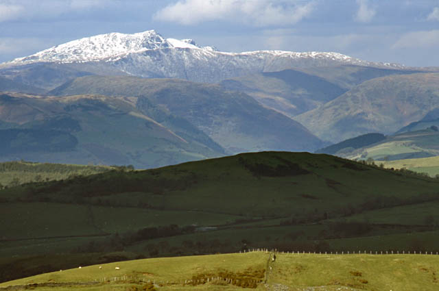 This was a typical view from the Machynlleth-Llanidloes mountain road during the period...... |
|
 |
|
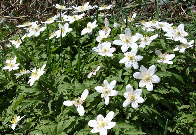
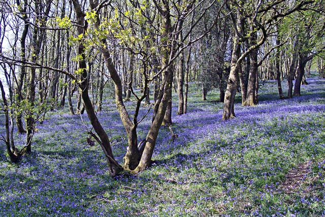
One of the best things about this part of the world is the profusion of Spring flowers along the hedgrows and in the woods. Wood anemone (above), celandine, primrose, stitchwort (below) and bluebell make such places a mass of colour and a joy to behold....  Along the Machynlleth-Aberdyfi road, just east of Pennal, is the most spectacular bluebell-wood locally, but you need to catch it bang-on at the right time, when the bluebells are in full bloom and yet there is not to much light-obscuring leaf-growth on the trees - just a bit to give an added bit of colour. Then, you need the right light - a cloudless day with the sun almost overhead is about right, so the weather-pattern is critical in order to capture it in all its glory. This year I was lucky to get everything coming together at the right time: |
|
 Nearby, in the only convenient layby, about half a mile away, these dandelions pushing up through some old tarmac made an inspiring subject! |
|
 Anyway - on to that gust-front! After seeing one waterspout this year but missing another, any chance of convective storms over the sea demanded a response from me! On April 24th there was some fairly intense early-morning activity just off Borth so I headed down and sat on top of the shingle at the Ynyslas Turn car-park, watching, waiting and listening to the last hour of the Today programme. No spouts ensued but I was to have a reward for the early start when, from what appeared to be the final cell of the batch, a tell-tale low ragged cloud raced towards me.... |
|
 |
|
A gust-front, formed by cold moist air brought down with the rain and hail, and fanning out along the ground, lifting warmer moist air up ahead of it, which condensed into the low ragged line of cloud. It didn't look much at first, but rapidly gained strength to start looking quite impressive.... 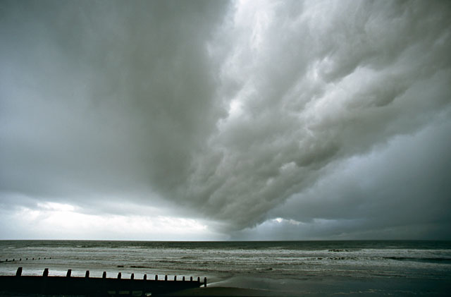 Almost overhead here: to get as much into the frame as possible I switched to my 19-35mm ultrawide zoom at its widest setting..... 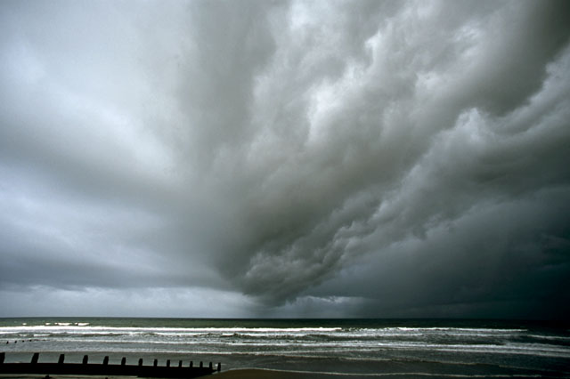 The turbulence is clearly visible to the upper R. To my east, this "guster" was really starting to look potent: 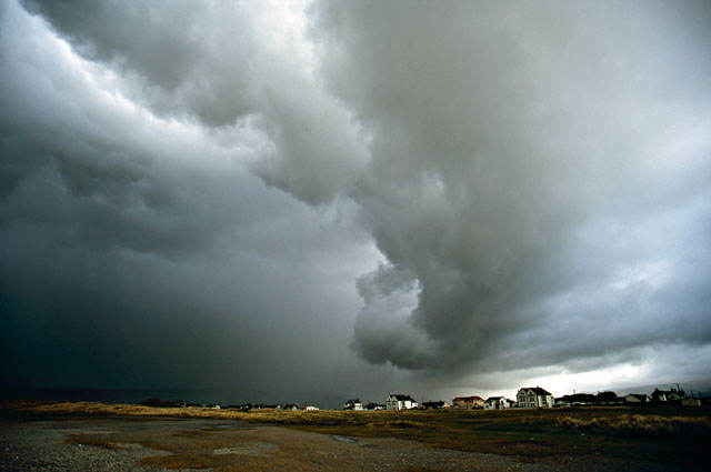 Moving over the small village of Ynyslas.... 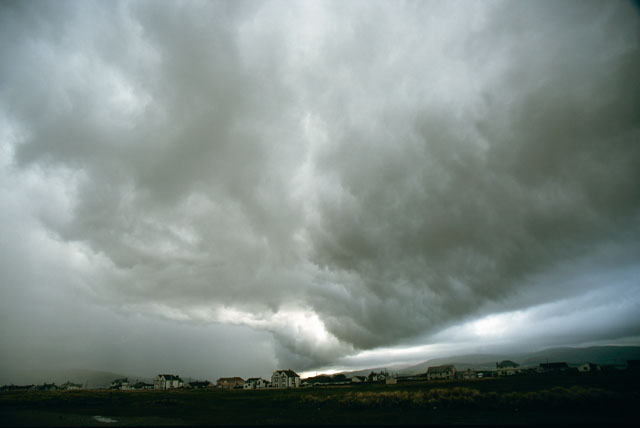 Pushing relentlessly across the landscape, the heavy precipitation that set it off visible to the L..... 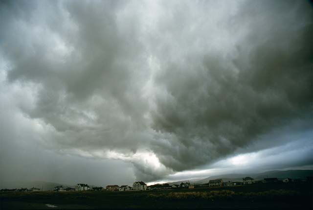 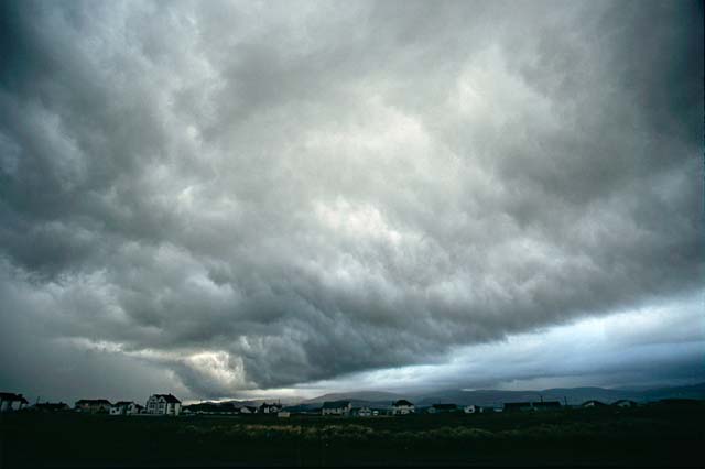 The vast space that opens up once inside the gust-front is known in storm-chasing parlance as the "whale's mouth" - an appropriate term! Its upper ceiling marks the actual cloud-base height for the area at the time - the Lifted Condensation Level or LCL as it is normally referred to. Its lower parts are the condensed moisture from the air the gust-front is undercutting and lifting. A week later (May 1st), on a day with a marginally unstable atmosphere, a group of storms developed very suddenly to the east of Aberystwyth. They seemed worth a look as the air was unusually clear so I headed south, meeting the forerunner at Talybont.... 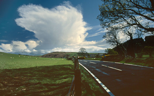 This rapidly grew, dwarfing the surrounding hills....  I headed in its direction, along the back-lanes towards Bontgoch, where lack of vantage-points was a problem. This was the best view I had, and even that was marred by the overhead cables! 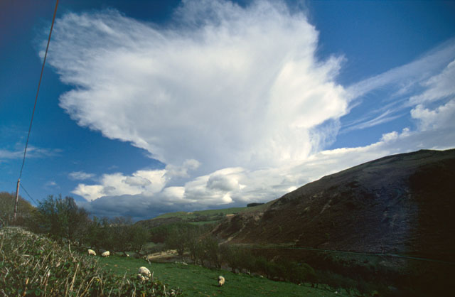 Outflow then surged out towards me, slowly obscuring the view and as the storms fizzled I turned and headed the 12 miles back home. Just a few lucky shots, grabbed by being in the right place at the right time! May saw further storm activity at times, plus a spectacular frontal clearance, with enough images to have their own page! |
|
BACK TO WEATHER-BLOG MENU New! Fine Art Prints & digital images for sale- Welsh Weather & Dyfi Valley landscapes Slide-Library - Click HERE |