AUTUMN
2005 - PART 2: First snow - November 25th:
Coast to Coast on the Cb-conveyor!
BACK TO WEATHER-BLOG MENU
New! Fine Art Prints & digital
images for sale-
Welsh Weather & Dyfi Valley landscapes Slide-Library
- Click HERE
 Well, winter's now upon us (December 10th) and the weather, with its own apparent sense of irony, has turned mild, grey, damp, anticyclonic and tedious. Perhaps this is a reaction to the media hype about the severest winter since 1947, 1963 or whatever other date springs to the copywriter's mind.... The thing is, winters of late have been above average in terms of temperatures, so that an "average" winter now would feel cold to many people and therefore demand for heating energy would go up sharply. The reality is that it's sensible with EVERY oncoming winter to be prepared for possible cold weather, even if at the end of the day it turns out to be a mild damp squib! Here I had the firewood stash nicely built up in time. In fact, there are now a few dents in it as a consequence of the late November-early December cold snap, which saw snow falling to sea-level on Friday 25th. The heaviest snow of the 25th was localised with westernmost parts of Wales and Cornwall seeing significant problems, inland Wales seeing some problems and some other areas hardly seeing a flake. Why? |
|
Well basically it's down to a couple of things. Firstly, at this time of year, if low pressure moves into the North Sea it can drag down a cold polar airflow. This manifests itself as a northwesterly round to northeasterly wind. Its orientation is critical. Unstable polar air flowing south over our relatively warm seas leads to convection occurring, as is well-known and illustrated elsewhere on this site for example. But, and it's a big but, the length of the track of this air over the sea is critical. Since temperatures over the land in cold weather are not supportive of convection, showers only tend to brew up over the sea. The ones that move in overland are mature or decaying cells, unless a strong extra forcing mechanism such as a low-pressure trough is present. Between Scotland and Northern Ireland is a narrow sea-channel - the North Channel, crossed by the Stranraer-Larne ferry. A NNW wind will transport cold air over the warm sea, picking up evaporated moisture as it goes, all the way down from Western Scotland, through the North Channel, past the Isle of Man, though outer Cardigan Bay and across the outermost parts of the Bristol Channel, with hardly any encounters with land - the NE coast of Northern Ireland, the Lleyn Peninsula, Pembrokeshire and Cornwall being the only obstacles to its convective progress. None of these areas are extensive enough to kill off the convective process. Therefore, what we end up with is a continuous narrow line of vigorous convection through the area. Because of the role of the North Channel in supporting such a weather setup, this is known, appropriately enough, as the North Channel Effect. |
|
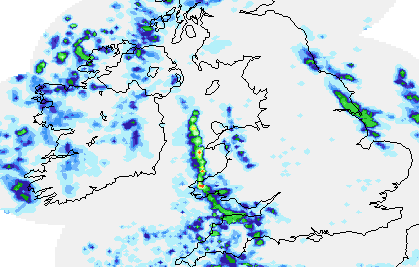 Here is the Net-weather subscription radar for 0730 on the 25th November. Convective showers are initiating just south of the North Channel and moving down the narrow line - note how the line is not dissimilar in width to the channel itself. They are becoming heavy to the south of the Isle of Man, and then as they move south one after another they are clipping the tip of the Lleyn Peninsula, affecting Pembrokeshire and running into SW England where they are losing their intensity. Thus, a long narrow conveyor-belt of cumulonimbus clouds is present - also known as a shower-train. The showers are moving along it, but it (the conveyor, that is) hardly changed its position all day. Note also a second train of showers is developing SE of the Isle of Man and running into the N Wales coast. This air, however, has had a much shorter run over the sea and thus the showers are less intense and shorter-lived. The distance travelled by the air over the sea is critical. Incidentally, a NE wind would NOT support the North Channel Effect and all we would see in that instance would be a few snow-flurries forming over Liverpool Bay and drifting onto the North Wales coast. Another important point for the aspiring weather photographer is that polar airflows are beautifully clear and crisp - which makes the job an awful lot easier! So, onto the fun stuff. I had an early start on the 25th and well before it started to get light I had identified the convective line on radar/infrared satellite imagery. This was worth a look I decided, what with cumulonimbus clouds to the west and an impending sunrise, so I set off down to the coast at Borth through light snow-showers: no more than 1-3cm had fallen overnight and the roads were fine so long as steady progress was made. All the way down to Borth I could make out the convective conveyor and anticipation of something good started to grow and grow! |
|
 The view upon arrival, with the rising sun clipping the tops of the cumulonimbus clouds, and a sprinkling of snow on the shingle at the head of the beach. The conveyor stretched across Cardigan Bay from coast to coast - from Bardsey and the SW Lleyn Peninsula in the N to Strumble Head and Pembrokeshire in the S.... |
|
 Looking back inland to a cold dawn and remnant snow-showers over the Cambrian Mountains... |
|
 This is looking west a while later (some of these are taken with a 28mm lens, hence the slight curvature of the horizon)..... |
|
 Meanwhile, light levels were increasing and I was distracted by the second inland line of snow-showers referred to above. You can see that they are weaker affairs (no North Channel Effect!) but are still producing small and quite photogenic cumulonimbus cells... |
|
 ...perfectly aligned into a line again, but the foreground needed to be better... |
|
 ...that's better! Borth's wet sand comes into its own once again! |
|
 Back to the main Cb-conveyor anyway! At this point some particularly powerful cells started to develop upstream: these would pass me within about 15-30 minutes so it was telephoto-time.... |
|
 What struck me from my vantage point was how solid-looking these cells were - like glaciated walls of ice on this side - the eastern side of the North Channel Effect's sphere of influence - with clear air between them and myself.... |
|
 The conveyor's eastern side was some 15 miles to my west, so that the snow and hail could be seen as distant precipitation-shafts, and from time to time C-G lightning stabbed down into the sea. This is, therefore, an outbreak of thundersnow, as it's popularly called. Notably, later on the same day, four people were struck by lightning from a cell on the same conveyor. Their misfortune occurred in the Prescelli Hills of Pembrokeshire, an area in which the snow caused considerable traffic problems - the BBC reported that "Dyfed-Powys Police advised drivers in Carmarthenshire and parts of Pembrokeshire to travel only if their journey was essential on Saturday." These drivers were right under the conveyor so they got hit by every snow-shower that ran along it over a period of more than 24 hours.... |
|
 This cell looked particularly magnificent and was indeed the best of the trip.... |
|
 The incredibly solid anvil reminded me of an Independence Day spaceship! |
|
 All of the time new convection was activating in this boiling, busy mass of thunderclouds... |
|
 However, by 0900, as the light levels increased, so the sharp definition within the clouds decreased a little: I was now a) cold and b) hungry, so happy with my "haul" I headed home for a seriously large breakfast, leaving the empty beach to the gulls and the oystercatchers. In its various guises, this conveyor persisted all through the following weekend as the northerly blast continued, although as temperatures crept back up it began to give hail and sleet showers instead of snow... |
|
 ...with a final shot from this remarkable spell of weather, taken on the Dyfi Estuary at sunset on Monday 28th November - still with the odd cumulonimbus popping up on the conveyor! Cumulonimbus clouds make great subjects for photography, and this was one of the most satisfying "shoots" I have had with them! Now, I wonder what the rest of the Winter will bring??? |
|
BACK TO WEATHER-BLOG MENU New! Fine Art Prints & digital images for sale- Welsh Weather & Dyfi Valley landscapes Slide-Library - Click HERE |