BACK TO WEATHER-BLOG MENU
The Welsh Weather & Dyfi Valley landscapes Image-Library - Click HERE
First, we need to look at how this major incident developed, then we can look at its after-effects. The synoptic chart for the early hours of November 17th shows the UK in a large cyclonic circulation, with the parent low centered just to the east of Iceland at 972 Mb. The area I've circled in red is the interesting bit: it's a developing wave with an active cold front and showery trough (straight black line) following on behind. The feature was to develop and move across Wales and England during daytime on the 17th.

The shipping forecast for Cardigan Bay was unexceptional for the time of year: "west or north-west 5-7, increasing gale 8 or severe gale 9 at times. Squally thundery showers".
THE EVENT AS IT UNFOLDED
The following radar plots are from the Netweather Extra subscription service which represents excellent value. At 0825, a large area of showers was producing lightning strikes (red crosses) off south-east Ireland:

Now we zoom in to Cardigan Bay at 0945. Note the bright colours forming a hook-like shape. These represent the heaviest rain/hail (scale on RHS in millimetres per hour) 30-40 mm/hour is pretty torrential. The linear shape indicates that the system has organised into a squall-line. The southern point of the hook, where it curves around to the right, may indicate rotation in that part of the the storm system - a mesocyclone. Hook-shaped echoes like this are a focus of attention for storm-chasers because they are likely areas for tornado formation, although not all hook-echoes produce a tornado - and tornadoes can be produced from storms without hook-echoes. Meteorology can be a fickle mistress!
The next few images show its progress across Cardigan Bay over the following half-hour. Note the fanlike patterns in eastern Cardigan Bay. The radar here has some issues and often under-reads precipitation intensity.


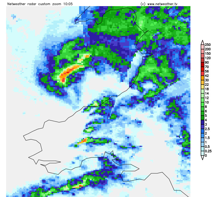

Now closely approaching the coast. Four minutes later, a gust of 82 knots (94 mph) was recorded at the Lifeboat Station at Aberystwyth (marked by the red X) . We'll now look in more detail, capturing the feature's progress every 5 minutes:

10.35. Four minutes later, a gust of 78 knots was recorded at Alan Cole's weather-station at Ynyslas, which is just R of the base of the hook shape, on the south side of the obvious inlet that is the Dyfi Estuary.


From 10.45 through 10.50, the feature went through Machynlleth. The timing of the peak gusts at Ynyslas and Machynlleth indicate that this storm system was moving forwards at close to 60mph. In fact, by 13.00, the feature was crossing the North Sea coast near Grimsby. That's some mover!


So, here in Machynlleth there had been patchy moderate rain for a few hours with a rising SW wind. Thunder was heard a few times around 10.30, but distant and to the west - there were several lightning strikes just before landfall.
I was stood at my NE-facing front door watching the system's arrival. A near-gale was rising and blowing the rain R-L - it tends to do this in S-SW winds. Suddenly, and with an almighty roar, the wind veered W-NW, increased to storm-force levels and brought forth horizontal hail and rain, this time going L-R. Volleys of hail were ricocheting off roofs and piling up on the ground in small drifts. Trees were swaying violently. Within a few minutes the tempest petered out and it was back to rain. The photo below was taken at its height, but such things are difficult to do justice to in still photographs. Camera date-stamps this at 10.44.

A friend, Andrew Isherwood, keeps a weather-station at his house in Machynlleth, admittedly in a more sheltered location. The temperature-drop, dewpoint-drop, peak gust and minimum pressure are all sharp deviations that mark this short-lived event:

Some more weather-station data, from the RNLI at Aberystwyth and Alan Cole at Ynyslas, is worth noting:
TEMPERATURE
At Aberystwyth, the outside temperature had been steady at around 9.5-9.9C for the past few hours but by 10.39 GMT it had fallen to the day's low of 7C, before recovering to 10C by 11.30.
At Ynyslas, the temperature fell from 9.22C following the gust: by 10.45 it was only 5.6C.
DEW POINT
At Aberystwyth, 6.7-7.2C before the event but peaking at 8.3C at 10.29, and staying around 7.8-8.3C until noon, after which it fell back a degree or two.
HUMIDITY
At Aberystwyth, 80-85% before the event rising to a daily maximum of 95% at 10.45. Fell back into the high 70s-low 80s thereafter. 91% at Ynyslas at 10.39, falling to 83% by 10.42 then rising to 89% by 10.45.
WIND CHILL (FEELS LIKE) TEMPERATURE
At Aberystwyth, 4-6C before the event, plunging to a daily minimum of -0.6C at 10.38 but back to 3.5-5.5C thereafter.
PRESSURE
At Aberystwyth, 995.6Mb at 0930, falling to 992.2 by 10.30 and daily low of 991.7 at 10.34. Recovered to 993.6 at 11.00.
At Ynyslas, pressure fell from 988 mb at 10.37 to 987.26 at the time of the biggest gust. A rapid rise then occurred to 990.5 mb by 10.44.
WIND
At Aberystwyth, 17 knots for a few hours up until the squall; at 1030 it had
jumped to 31 knots and remained in the 20s and 30s for several hours
thereafter. Gusting to 18 knots for a few hours up to 1030, when a
37.6 knot gust occurred. The 82 knot gust was at 10.34 and 30-40 knot
gusts occurred in the following hours. In the few hours up to the
squall, winds were SSW but suddenly veered westerly with the passage
of the squall.
At Ynyslas there were gusts of 25-35 knots up to 10.40 when there
was one of 78 knots, followed in the next few minutes by gusts of
44-55 knots.
RAIN
Only a millimetre of rain fell at Aberystwyth, in the hour ending 11.00.
At Ynyslas it was dry when the 78 knot gust hit. 1.4224 mm were
recorded in the next five minutes, of which 0.6mm fell in the minute
to 10.42, equating to a rate of 36.5 mm per hour..
However, on Facebook, in among the crappy photos of kittens, reports started to come in: the wind-gusts, the damage, the road-closures. Every time the BBC Travel webpage for this part of Wales refreshed, there were more and more red flags appearing. Then came reports of a caravan-site at Clarach Bay (a mile north of Aberystwyth) having been damaged by a tornado. By lunchtime it was all over the news and social media.
But the spread of damage sparked my curiosity. Incidents were all over the place and we had those huge gusts recorded from locations several miles apart, at Aberystwyth and Ynyslas. So that afternoon and in the following two days I covered as many roads as I could manage between Aberystwyth and Machynlleth armed with maps and camera.
SITE INVESTIGATION RESULTS
The map below shows key damage, fallen trees (all large ones, mainly mature sessile oaks) and four areas with more damage that I investigated more closely. Since these were spotted from the roads, and there are many roadless tracts hereabouts, the total number of trees down in this area is likely an order of magnitude more. But we can use these as a sample.
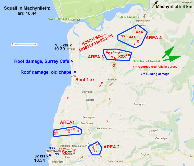
Clarach (area 1) was an obvious place to visit. At the coast, the westernmost caravans showed little signs of disturbance. The Holiday Village runs inland from here, along the valley floor, for about a kilometre. In the conifer-forest on the steep south side of the valley, I could see some freshly-snapped-off trees (circled in red). There are also older snapped and felled trees, probably dating back to the furious windstorm of February 2014.

The Holiday Village entrance was barred-off, but at the eastern end, people were at work and fallen tree-debris can be seen. Here, several caravans were up-ended and some were destroyed.

Open fields then stretched for a kilometre eastwards to the Aberystwyth-Borth back-road. Alongside the road I found an area of tree-damage, L of the telegraph-pole. Bow Street is the village in the distance.

Details of the damage. Two trees were blown over and others had branches snapped.

About halfway along the road to Bow Street, another area of damage was located in woods on the south side of the valley:

Zoomed, both optically and digitally. This looks fresh. However, time constraints precluded a closer look.

I had to go into Aberystwyth, so stopped at the top of Penglais Hill, by the University Campus (spot 2 on the map) to record these stout conifers in an exposed spot. They have lived through many windstorms but not this one. View is looking ENE, away from town.

In Aberystwyth, scaffolding was up around a fair few buildings needing mostly repairs to their roofs.
Area 2 was localised on the A4159, along a 500m section heading NNW from the Lovesgrove roundabout to the brow immediately before the hamlet of Capel Dewi. Here, three large trees had fallen straight across the road and others were visible in the neighbouring fields. This shot is taken by where one had fallen; another is circled in red further along.

Large tree snapped off close to ground level and indicative, had this been a tornado, of a T3 (93-114mph) on the Torro scale: "Some of the bigger trees snapped or uprooted."

Another view of the same tree. Note the lack of damage in the fields to the west.

This was becoming a regular pattern as I explored, with only minor damage for some distance then a cluster of mature trees uprooted, like this one, on the Taliesin to Dolybont back-road (spot 1 on the map).

Area 3 had a bit more of a track to it, beginning just to the east of Llancynfelyn church with this badly-mauled mature oak. Beyond towards the sea the land is low-lying with few trees.

To the east, and across the road from Tre'r-ddol to Llancynfelyn, several trees had been uprooted or snapped (red arrows):

Close-up of the left-hand one:

Immediately north of the school at Taliesin, and upslope from the A487, two areas of multiple tree damage were found about a hundred metres apart. This is the southern one:

And this is the northern one:

Zoom-in.

For perspective, here is a more distant view. Further damage is within the circled area:

Here zoomed-in again.

Area 4 starts 2km to the north of Tre'r-ddol, at this multiple tree/branch fall on the minor road to Hen-Hafod, close to its junction with the A487. This is a big uprooted oak.

Over the main A487 and just over 100 metres east of the last photo; this one has already been part-cut up by the farmer.

However, this one (and others) are further along the same wood-boundary to the L (or SW), over a couple of hundred metres.

Another large oak, 800m to the NE of the previous cluster, has been uprooted close to the A487; view is looking SW. More trees down on the other side of the road, out of the field of view.

Interestingly, the damage-swathes all peter out against the steeply-rising foothills of the Cambrian Mountains. Beyond there and as far east as Cemmaes Road, damage is very localised - a tree here and there (such as near Aberhosan and Penegoes) then kilometres of little or no damage. But the system clearly rejuvenated after crossing the Cambrian Mountains. Severe wind damage occurred along a track a few kilometres in width through East Wales, starting in the Meifod-Llanfair Caereinion district, continuing north of Welshpool, through north Shropshire, where RAF Shawbury recorded an 84mph gust, and on across the North Midlands. We're looking at a 200 km plus track from Aberystwyth to its end, which is pretty impressive. Investigations by TORRO staff have again identified a series of clusters of wind damage within this overall track and the damage is pretty much identical to that observed here in Mid-Wales. It's almost as if the thing had a pulse!
SUPPLEMENTAL SITE INVESTIGATIONS: CWM LLYFNANT TO LLANBRYNMAIR 25th NOVEMBER
This section of the storm's track features widely separated clusters of tremendous damage, with stuff like the photo below dotted about here and there and indicative of storm-force winds widely, but hurricane-force winds just locally.

Four key areas of major damage were detected on November 25th - three on the map below, the fourth around Llanbrynmair, further to the ENE. They are recorded below west to east.

Most of Cwm Llyfnant, south of Machynlleth, did not fare badly. However, towards the head of the valley at Cwmyrhaiadr farm, there was perhaps the most intense damage-swathe of all, some 200m in maximum width, here viewed from the road on the opposite bank of the stream:

Looking up the road as it approaches the farm:

Closer to the large softwoods. Very high glare in the early morning light, but one can see multiple large trees down:

Multiple trees uprooted; others snapped. Fall direction NE round to ENE.

The root-ball of one of the larger trees, giving an idea of its sheer size. Cut-off trunks are visible over the road.

And yet, 100m "downwind" of the damage-track, not a scratch anywhere!

South of Talbontdrain, near Hengwm, was an extensive swathe of damage, as if the wind ploughed into the edge of the wood. Its position, a kilometre south in latitude from Cwmyrhaiadr, suggests this was a separate blast of wind as the overall storm-track was SW-NE.

Severe damage-cluster no. 3 was north of the farm of Cefncyfrifol, some 2km SW of the village of Aberhosan. On this ground is a long N-S field and for over 500 metres along its length, there was severe damage to sessile oak trees: some uprooted, pulling up a lot of bedrock, others with snapped branches. One projectile (a 40 x 2cm stick) was found, sticking straight out of the ground - the only one noted in the entire damage survey. Following major tornadoes, such things are a frequent sight.

Again, one would follow the damage to the NE, going from devastation:

...to lighter damage...

...to nothing within a hundred metres.

Here were also found much longer branch-throw than elsewhere. The larger of the two here has travelled 20 metres from the parent tree - although I guess it may have been rolled along the ground.

Smaller branches were dotted about across the field to the NE. The oak in the centre of the image is the same one as in the last shot. This is one area in which the damage and behaviour of objects may indicate a vortex at work, if only locally.

Another uprooted tree in this group: it has brought up plenty of bedrock -

Looking northwards, other areas of damage may be discerned:

This one was especially intense:

Multiple large oaks uprooted:

To the east of here, scattered damage indicative of storm-force winds was encountered until arriving at Llanbrynmair, when pockets of severe damage were met with both south and west of the village. This is part of the southern one: nearby another large tree had been snapped-off.

This quick graphic shows the swathe of storm-force winds (blue), with red stars showing clusters of severe damage. Roads coloured in red have all been driven: others still could be traversed though I think this gives a good indication and time for this sort of work is not infinite! This has already become one of the biggest site-investigations undertaken by TORRO in its history. In the southern half of the swathe there is a lot of high ground, which does not record damaging winds well if at all: forestry plantations do exist but because softwoods break easily, damage in such areas can be hard to interpret. Hardwoods are much stronger and freshly broken ones are easily identified, so they make more reliable indicators of severe winds.

Here is a map of damage recorded by myself and Matt Clark of TORRO (apart from reports west and north of Welshpool, which were gleaned from tweets by Dyfed-Powys Police and the Mid-Wales Fire Service), as of November 25th:

DISCUSSION
So: we have an intense squall-line thunderstorm system with an apparent hook-echo, moving NE at almost 60mph and associated with a broad swathe of serious damage. Were tornadoes involved? I don't think there's anything but locally suggestive evidence, such as the damage track at Llancynfelyn. Things like a roaring sound or uprooted and snapped trees are NOT evidence for a tornado: they are just evidence for very high winds. Neither is sideways hail evidence for a tornado. Violent winds laden with rain, hail or snow often swirl around wildly but that is different from a large, organised rapidly rotating structure. Damage-patterns with tornadoes typically involve debris flung out from the rapidly-rotating air in all directions. In this case, all trees have fallen in approximately the same direction, here in Wales and likewise across Shropshire. Tornadoes litter their paths with heavy debris, often penetrating the ground surface. In this case the ground between damaged areas was clear. Contrast that with the image below, taken after the November 2006 Bow Street tornado, which was T4 in strength, doing somewhat worse property damage and similar tree damage. It didn't just destroy sturdy objects; it carried them along. This chunk of portacabin was airborne (or bounced along) for several hundred metres from where it was struck.

Finally, the scattered, clustered nature of the damage and the non-ignorable fact of very high gusts at Aberystwyth and Ynyslas weather-stations, the best part of 12km apart on a north-south line, are incompatible with any tornado spawned with a hook-echo like this: the tornado would travel with the hook, in the SW-NE course it exhibited. Not only that: a strong tornado associated with a fast-moving storm like this would have the strongest winds on its leading edge: if it were moving SW-NE its leading edge winds would be south-easterly, for tornadoes are mostly cyclonic in nature - they spin in an anti-clockwise fashion.
The photo below illustrates this point neatly. It was also taken after the November 2006 Bow Street tornado. The big red arrow shows the course of the tornado, towards the NE. The little red arrows show the wind circulation (although in effect the windfield would have been much wider). Now look at the oak tree. Its branches have mostly been snapped-off and the resultant debris has been flung out to the north-west, landing all over the slope to the left of the tree. This is a classic example of cyclonic debris-throw, as it's termed. Not one instance of this has been found from the November 17th event: all trees have fallen pointing to the north east round to the east.

Tornadoes are not, however, the only violent winds produced by thunderstorm systems. There are downbursts and microbursts, both of which involve cold air flowing rapidly out of and ahead of the storm-cloud from high up - and hitting the ground, fanning out over it. Downbursts are large affairs: microbursts are usually defined as affecting areas less than 4km across - although on storm-systems like this they may occur in clusters that merge together.
Downbursts and microbursts occur through two processes. Firstly, if dry air gets ingested by a storm-cloud, it will encounter droplets of moisture that then evaporate. Evaporation takes up heat, so the air temperature is lowered in the phenomenon known as evaporative cooling. As dry air carries on feeding in, a great mass of cool air accumulates and at some point it starts to sink down through the storm-cloud, gaining speed both through gravity, cool air being dense, and through encountering progressively warmer (and so less dense) air further down. Not only that, but the millions and millions of falling raindrops and hailstones help to drag the cooled air downwards, so it can go even faster. A wet microburst, defined as one that arrives with lots of rain and hail (as in November 17th's storm) can generate very strong winds indeed: firstly the parcel of cool air and rain rushing groundwards can reach a descent speed of 60mph. Then, you have the forward motion speed of the storm to add to that.
A fast-moving storm like the one on November 17th, whose forward speed was getting on for 60mph at times, could therefore produce a wet microburst of up to a possible 120mph. The storm winds, sampled at Aberystwyth and Ynyslas, were only 25mph less than that and in places with height/exposure that speed could have increased. During the survey, the tree damage was found to be concentrated on ground exposed to the west and south-west: little or no severe damage was noted on lee-slopes.
This diagram (source = http://www-das.uwyo.edu/~geerts/cwx/notes/chap08/microburst.html) shows how microbursts can produce vortex winds:

As such vortices spread out and tighten, the winds within them become markedly stronger. Furthermore, if the horizontal vortices become tilted, tornado-like air motion may be observed. During the November 17th event, some witnesses saw such vortices depicted by flying leaves and other light debris. The evidence of long-thrown branches at the Cefncyfrifol site may indicate a degree of such activity, although it is an exposed site so that the straight-line winds here may have been especially forceful.
In slow-moving storms, wet microbursts can fan out in all directions (think of a balloon full of water, dropped onto a concrete slab), but in fast-moving storms the wind and the rain-hail mixture of the wet microburst drive along ahead, like a high-speed bulldozer tearing its way through the countryside. Extreme versions of the phenomena, producing widespread continuous damage along tracks hundreds of kilometres in length, are called derechos. Derecho winds are not constant, varying through time and along different parts of the system, locally non-severe and locally extremely severe. The reason is because a derecho consists of a line of constantly renewing downburst and microburst clusters, each individual "burst" having its own characteristics, so you get weaker and stronger examples popping out along a line of storms as it moves along its course.
To conclude, in Mid-Wales I have yet to see good evidence for tornado activity and a progressive, wet microburst-cluster, with damaging winds of at least 94mph, is the most likely culprit. It explains why all the trees fell the same way and why the severe damage occurs in clusters while elsewhere it occurs as isolated instances. However, if anyone does come across better evidence for tornadic activity in this part of Wales, then please get in touch!
The Welsh Weather & Dyfi Valley landscapes Image-Library - Click HERE
BACK TO WEATHER-BLOG MENU