BACK TO WEATHER-BLOG MENU
New! Fine Art Prints & digital images for sale-
Welsh Weather & Dyfi Valley landscapes Slide-Library - Click HERE
The shore beneath the cliffs at Friog, to the south of Fairbourne on the S. Gwynedd coast, is a place steeped in history. Here in the 19th Century was forced a route for the Cambrian Coast railway, which makes its way along a ledge cut into the cliffs, with a main road above. It is the location of two historic railway accidents, in 1883 and 1933, both of which involved locomotives falling to the shore beneath. Work to reinforce the locally unstable cliffs here and there is often spoken of by local railwaymen with pride.
In 1997 a series of discoveries led to the site becoming a SSSI and making its way into the scientific literature. The reference is:
Mason, J.S., Fitches, W.R and Bevins, R.E. 1999. Evidence for a pre-tectonic origin for the auriferous vein-type mineralisation in the Dolgellau Gold-belt, North Wales. Transactions of the Institution of Mining and Metallurgy (Section B, Applied earth science), 108, B45-B52.
More about that below. First a general look at the section and the sequence and types of rocks it displays.
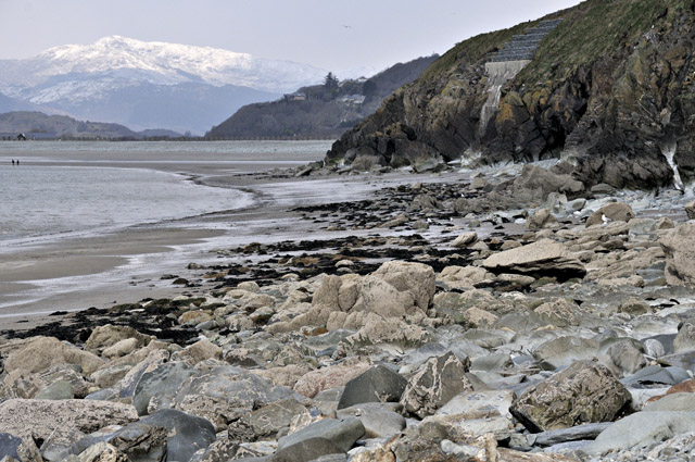
The image below is taken looking back along the section towards Fairbourne beach, with the snowy southern Rhinogs in the background. The point in the middle distance is important as it dictates the site's accessibility: on a big tide one has perhaps two hours either side of low water. On smaller tides the window is much less and it's a wade if one gets cut off - no problem on a fine calm summer's day but a risky proposition in a winter storm!
Storms do a useful job of keeping the sections scored clean. For this reason, winter is in fact the best time to visit. High summer sees green seaweeds covering many features plus the abundant nesting seagulls on the cliffs above mean that geologists may get mobbed and the rocks are liberally spattered with bird shit. Go there on a still winter day and it's a lot pleasanter and more photogenic.
 |
The section is essentially the SW tip of
the Cambrian outcrop of the Harlech Dome. The Cambrian strata of the
area (L - taken from the Geological Survey memoir) form a sequence of
some 4000m plus in thickness, spanning a
time period of 541-485 million years ago. At Friog, only part of the Middle Cambrian is seen. These rocks are younger than those forming the high ground of the Rhinogs and illustrated in the previous post on the geology of the area. The lower Cambrian strata, with their pebbly sandstones, are interpreted as having been deposited in a shallow, perhaps deltaic environment. By the Middle Cambrian, deeper waters covered the area and sediment deposition was taking place in what was essentially a marine basin. At times there were periods of anoxia in the sea water, leading to the accumulation of black, organic-rich muds. Later in the Cambrian and into the Ordovician there was a period of uplift, with the intrusion of igneous rocks before the onset of volcanism in the early Ordovician. Boulders of volcanic rocks are common along the shore at Friog, having been transported down to the coast from inland during the last ice-age. Numerous quartz-sulphide veins were emplaced sometime after the late Cambrian and they were deformed along with the Cambrian strata during the Acadian earth-movements that took place during the Devonian period, somewhat less than 400 million years ago. As a consequence, the sequence at Friog is tilted landwards at some forty to fifty degrees. |
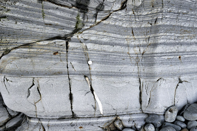
Let's take a look at the sequence, starting with the oldest rocks exposed at Friog, the Gamlan Formation. These are rather massive, erosion-resistant strata consisting of mudstones, siltstones and thick sandstones, as shown in the image below:
Towards the top of the Gamlan Formation the rocks become thinner-bedded with the appearance of dark, organic rich mudstones alternating with thin sandstones and siltstones. These beds are transitional into the overlying black mudstone-dominated Clogau Formation.
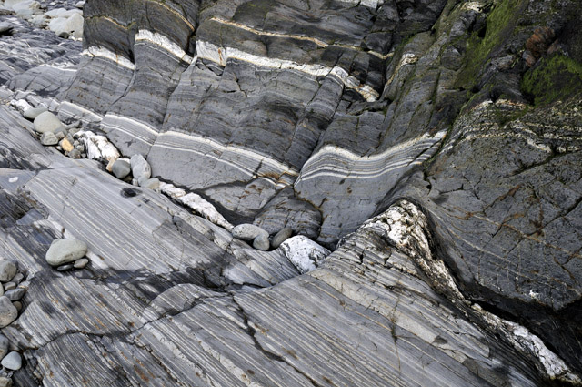
The Clogau Formation comprises finely laminated mudstones and thin siltstones. The rocks contain abundant organic matter and the iron sulphides pyrite and pyrrhotite are ubiquitous as fine disseminations:
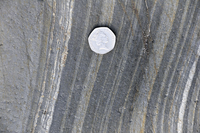
Locally, thin very pale bands occur in the Clogau Formation:
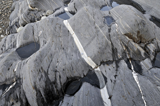
The origin of such bands deserves investigation: I wonder if they could represent airfalls of fine volcanic ash? The abrupt change in rock-type is a noteworthy and typical feature.
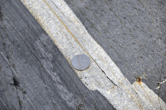
A lot of the overlying Maentwrog Formation consists of rhythmically-banded siltstone and fine sandstone, again with sulphides (marked by the rusty-weathered spots in the image below) but the lower and upper parts of the formation exhibit some distinctive features that has led to the subdivision into the Vigra and Penrhos Members respectively.
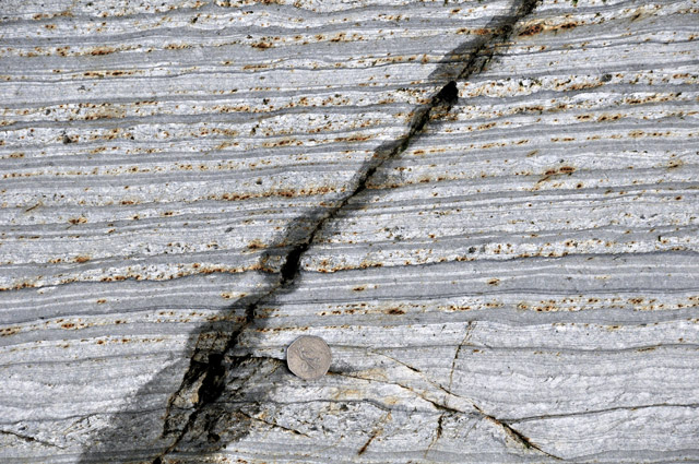
The Vigra Member (formerly the Vigra Flags) features some thick sandstone beds:
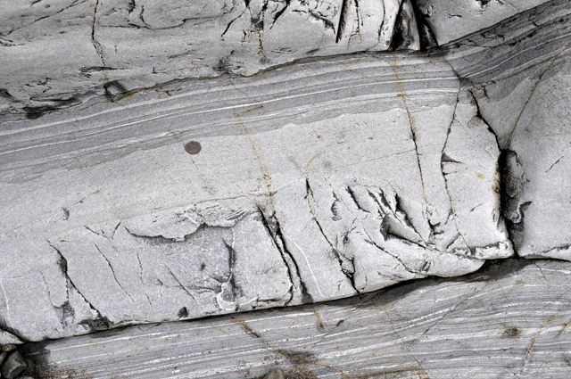
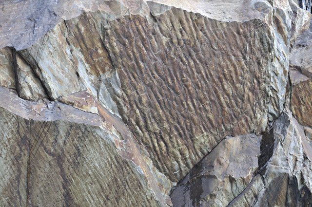
Ripple-marked surfaces are common in the Vigra Member: this is the underside of a bed dipping into the cliff....
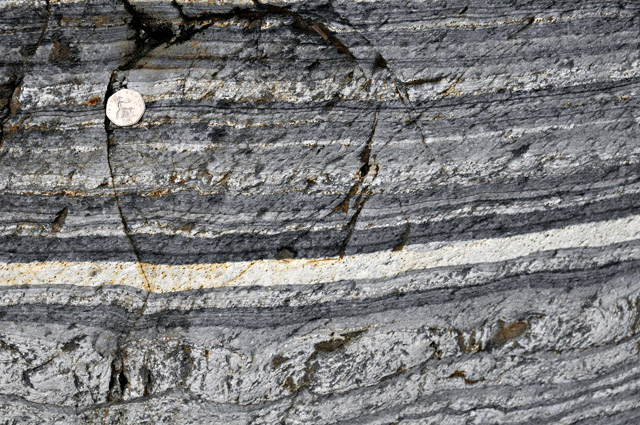
The upper or Penrhos Member sees a periodic return to rather anoxic conditions with the deposition of dark, organic- and sulphide-rich mudstones occurring in between the siltstones:

This outcrop of the Penrhos Member is interesting: note there is another of those very pale bands as seen in the Clogau Formation, with an anoxic band immediately above it with a sharp junction, before a return to the more typical siltstones:
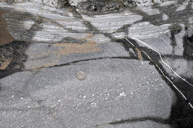
Intrusive sills, common around the Harlech Dome in general, are only present very locally at Friog, where they intrude the Vigra Member. Here's one, just a metre or two thick, with white calcite filling what were originally gas bubbles. The contact with the Vigra Member thinly-bedded siltstones is clearly visible in the upper part of the image:
Onto the veins. The Middle Cambrian outcrop around the Harlech Dome forms the mineral province known for over a hundred years as the Dolgellau Gold Belt. Gold has been mined here since the 1840s from mesothermal quartz veins that form swarms of sub-parallel bodies on all scales from millimetres to locally over ten metres in thickness and which can vary from vertical to nearly flat-lying. Branching is frequent, to the extent that the whole mass of mineralisation can be envisioned as a sort of Celtic knotwork extending across the district. The veins cut both the sedimentary and intrusive igneous rocks. In detail, a typical vein structure is shown below, in a large polished slab from the Cefn Coch gold-mine. Individual quartz-carbonate-sulphide veins occur packed together in a ribbonlike arrangement (or as locals put it, "like streaky bacon"), indicating that the host fracture-zone kept on opening and reopening as fluids flowed through, depositing minerals in the fissures, sealing and resealing them time and again:

As well as quartz and carbonates, white mica is common. Sulphides include pyrite (iron sulphide), arsenopyrite (iron sulpharsenide) and cobaltite (cobalt sulpharsenide): these three minerals are early in the time-sequence of deposition and often impregnate the rocks on either sides of the veins. Galena (lead sulphide), sphalerite (zinc sulphide), chalcopyrite (copper iron sulphide) and pyrrhotite (another iron sulphide) are all later in deposition and are locally abundant. More obscure minerals include cubanite, mackinawite, tetrahedrite and pyrargyrite. Gold is localised in its economic occurrence and occurs in high-grade 'shoots' as the visible native metal; it may be associated with a range of tellurides of bismuth, silver and lead.
At Friog, pyrite, pyrrhotite, arsenopyrite, chalcopyrite, galena and sphalerite can all be found. In the example below, waterworn pyrite is visible but sphalerite has weathered away leaving dark holes.
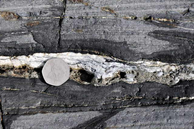
Most of the veins at Friog are small but larger examples do occur:
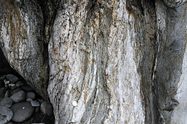
Up until the 1990s, the accepted wisdom was that these veins post-dated the folding of the rocks of North Wales in the then-named Caledonian (now called Acadian) Orogeny; however, the discovery of highly-deformed veins at Friog overturned that paradigm. In fact I and a few others had held a suspicion that the veins were deformed prior to that, but underground exposures in the mines tend to be mucky affairs and do not do the subject justice compared to the amazing wave-polished exposures at Friog. Visiting this site for the first time in 1997 was one of those 'eureka' moments all scientists dream of!
That the veins belong to the same group as the rest of the Gold Belt is not in doubt: texturally and mineralogically they fit in just fine. Just to add to the evidence, the image below is of two thin-sections of gold-vein quartz from one of the gold mines, viewed down a microscope: the field of view in each case is just a few millimetres. To the experienced mineralogist, two things stand out. Firstly, the quartz is not nicely crystallised but instead forms a series of interlocking grains. In the right-hand example, which is at higher magnification, the boundaries between the grains look like a set of interlocking teeth - this is known as suturing. The left-hand image is taken under cross-polarised light which should normally mean that the grains each go from white to black (or 'extinction', as it is called) evenly, as the microscope's stage is rotated. They do not: instead they have a rather cloudy or shadowy appearance with some parts of each grain a bit darker, or lighter, than others. Suturing and shadowy extinction are both features typical of quartz that has recrystallised during deformation.

The vein deformation at Friog takes on a number of forms. Veins that are oriented in such a way that they were squeezed from their sides by the stresses involved in the deformation of the rocks have tended to break up into a series of pod-shaped forms with fractures cutting across them at right angles. In the example below these fractures are the thin black lines cutting across the veins:

Here's a particularly good example. What happens is that when the maximum compressive stress is at right-angles to a vein, the minimum stress is parallel to the vein, so that it responds to being squashed by stretching a little in the parallel direction. If you jump onto a cow-pat with both feet, does it not splat out sideways? The same thing's going on here (though involving far greater forces). However, quartz does not stretch very well because it is brittle, so that breaks form at regular points and are subsequently filled by new minerals:
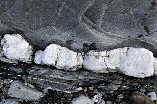
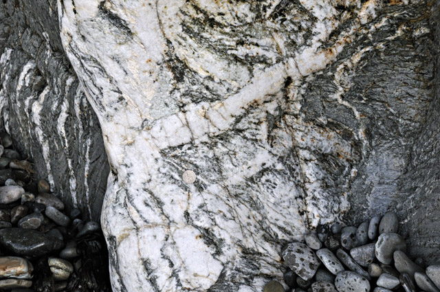
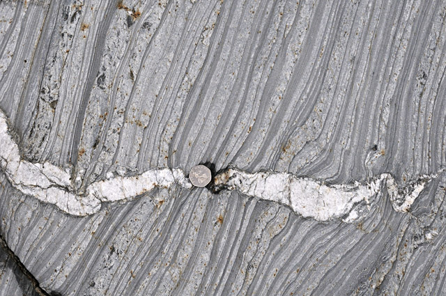
The process is known as boudinage, and can affect any rigid body of rock surrounded by a more ductile matrix such as the Cambrian mudstones of the Gold Belt. In the example below, the breaks across the vein are wider and have been mineralised by new, white quartz forming low-angle bodies such as the one in the middle, above the 50p piece. Such low-angle bodies of late quartz are common in the gold mines, where, because they contain no gold, but have still to be mined and trammed out of the tunnels because they are in the way, the miners nicknamed them 'white elephant' quartz!
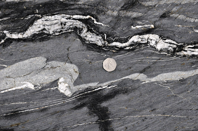
The folding itself is best developed in thin veins oriented parallel to the direction of the maximum stress, so that instead of getting stretched like the boudinaged veins, they got shortened. This they accomplished by buckling up into a series of folds and breaks. The folded veins at Friog are some of the best examples anywhere in the UK, as the following images show:
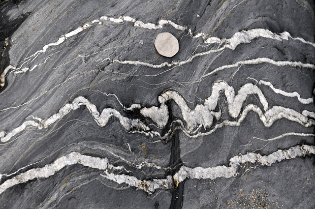
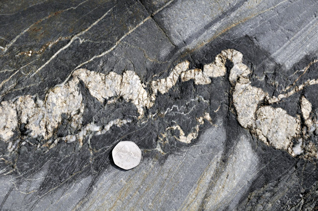
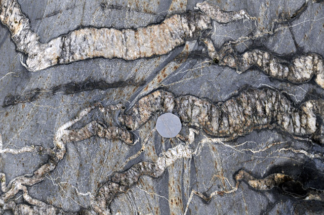
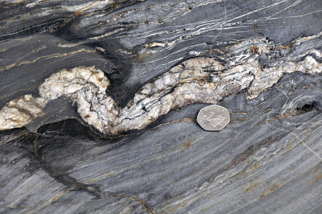
So, to summarise, what we now know, thanks to Friog, is that this important mineral deposition event took place sometime between the end of the Cambrian Period and the Acadian Orogeny. That's rather a long time-period, but we so far have just these two age-constraints: the deposition of the host rocks and the deformation. However, techniques of using naturally occurring isotopes of various elements to radiometrically date the minerals that contain them are coming on apace year on year, so that it is hoped that someone will take another look at these veins soon and nail their age down a bit harder.
For geologists into this sub-discipline of the subject - structural geology - or "twisted bloody stones" as one of my ex-lecturers (a microfossils specialist) put it, Friog is the sort of place where hours could pass by, absorbed in these amazing structures, especially if armed with a good camera. Just watch that tide, though!
.
BACK TO WEATHER-BLOG MENU
New! Fine Art Prints & digital images for sale-
Welsh Weather & Dyfi Valley landscapes Slide-Library - Click HERE