The July 3,
2001 Thunderstorms and their catastrophic effects in
Mid-Wales: Part 1 - the storms |
|
THE BUILD-UP: R:
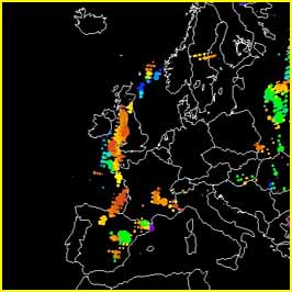
Sferics (lightning) plot for July 3 (thanks to Georg
Mueller of Wetterzentrale for
permitting use in this research). Yellow/orange plots are
from 4pm-9pm. These neatly delineate the position of the
trough during the early evening. Some of the plots
indicate intense lightning activity (>81
flashes/minute) which corroborates with eyewitness
accounts of "more than one flash per second". |
|
 |
 |
Below: Enhanced visible satellite image, courtesy of Bernard Burton. This was taken at 16.28 GMT and shows the low pressure centre west of Eire (swirl of cloud) and thunderstorm development along the trough (bright white, "hard-looking" clouds). Note shadows cast by the thunderstorm anvils to the east of the trough. The large cells over N Wales are clearly visible and are part of the same storm system as shown in the two photographs further down this page. 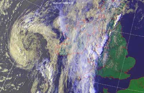 |
|
THE CHASE: By early afternoon, broken cloud covered much of the sky in Machynlleth. A glance at the BBC radar revealed convective activity taking off in a determined manner, along a N-S line through the Irish Sea, with the line drifting steadily eastwards.... By 5pm streaks of lightning could be seen looking SW down the Dyfi valley, so I jumped in the truck and set off towards Dylife (10 miles to the SE), hoping for a better view of what was going on. As it's a mountain road, it offers the best views hereabouts, although a major storm obscured things to the west and to the SW another one was fast approaching... |
|
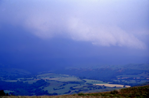
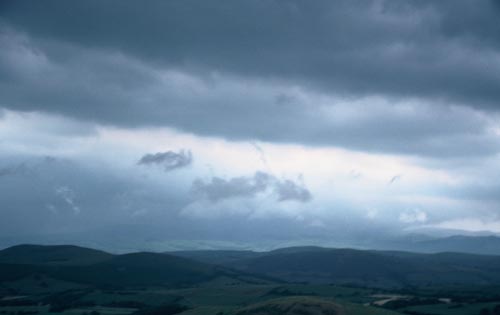 Tattered scud-cloud (small ragged low-level clouds) forming, breaking up and constantly moving N at a rate of knots along the flank of the storm-system, with remaining brightness to the S and E. A major storm-cell lies beyond to the W. The murky conditions were not at all good for photography - verging on appalling in fact..... |
|
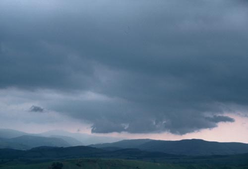 Localised lowerings coming and going.... I decided to head downhill a bit as this viewpoint was a bit exposed (in lightning terms) and as the second cell was now coming up fast from the SW all hell was about to break loose! |
|
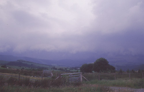 Uh-oh, here it comes.... Note the last vestiges of brighter sky above, while below a long, low straight line of clouds is heading my way. Behind/under that there is an inky blue-greyness swallowing up the landscape. That's the precipitation from the second cell. This gateway is at the foot of the first steep section of the pass.... |
|
 As this line of clouds and blackness got closer so did the lightning, but I got this shot. It is the same line of clouds as above, but now very close, and it marks the forward flank (an area of often strong, gusty winds) of one of the main storm cells; its flattish shape is responsible for the term "shelf-cloud". Such clouds tend to be associated with fairly well-organised storms - the severe ones and this is a reasonably good UK example despite the murk and clag everywhere! While I had been up here, this storm-cell was for a little while dropping near-golfball sized hail on the streets of Machynlleth (in the backness beyond) - cracking a friend's windscreen and causing shoppers to hastily take refuge. The lightning was now impressive - multiple CG strikes from yet another active cell following up from the S, but they were getting a bit too close to me, so that I decided to stay in my mobile Faraday Cage. More blind courage and some good lightning shots might have been on this page or alternatively I could have ended up a statistic. I was now surrounded, except to the N where there were no roads! I left and picked my way back down to Machynlleth just as the third cell moved over and dropped torrential rain on the town for 30 minutes. The last 15 minutes of this I watched with a crowd of people in the local pub. After it had subsided there were some flooded houses to help sort out, my mate's windscreen to commiserate over and as often is the case fog descended on the steaming mountains. |
|
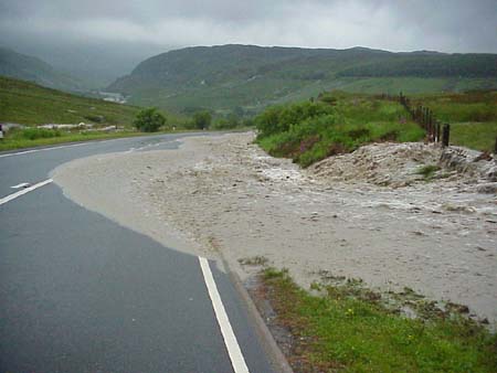
Activity continued along the trough intermittently until about 11am the next day, focussed largely over SW England and Wales. Wales had some high "official" rainfall totals (67mm in Cardiff on the 4th, with problems due to flooding), but it is the "unofficial" ones that concern us here, in the area between Dolgellau, Trawsfynydd and Bala. Some people had quite a night of it up there! THE EXPERIENCE OF BOB CHILTON: I am indebted to Bob Chilton of Capel Hermon for the following collection of images (which are his copyright), taken during his attempt to travel from Bala to Trawsfynydd during the storm. The road runs from Bala up to Cwm Celyn and its reservoir, a place of great notoriety in recent Welsh history (did you know the Highland Clearances were still going on in Wales in the 1960s? - if not click HERE for a new window). Then, carrying on towards
Trawsfynydd, the road goes over the watershed and
descends into Cwm Prysor. This is where Bob ran into a
"spot of bother". I leave the rest of the story
to his narrative: |
|
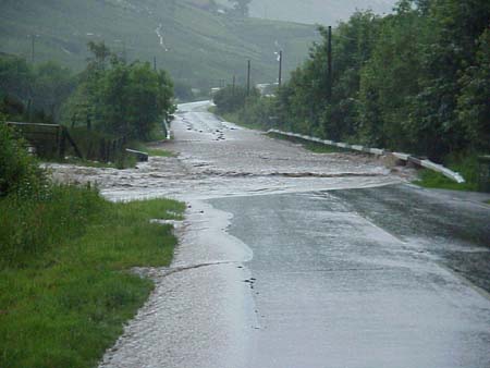
 ......and there were flashes of lightning and rumbles of thunder every few seconds. Then the rain became torrential and the flashes of lightning and simultaneous thunder were occurring about more than once a second. I asked my wife who was driving at the time to pull in but she could not see the side of the road and continued onwards slowly. Perhaps she was afraid of something coming up behind. Eventually she did pull in when we came to a river across the road half way down the hill to Cwm Prysor............ |
|
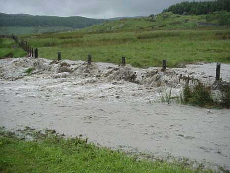
 Boulders and a 45 gallon oil drum were rolling across the road in front of us and we could see the valley floor was now a lake...... I got out the car, retrieved my camera from the boot and started taking pics. I thought water levels would go down as quickly as they went up but after 20 minutes this did not happen and we decided to retreat up the hill..... |
|
 We then met another river across the road which was carrying small rocks and stuff across the road into the higher of the two lakes....... |
|
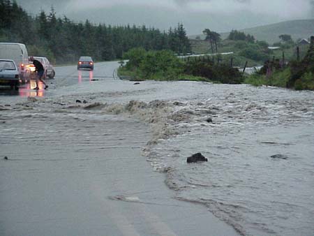 There were a couple of broken down cars here, a man running about in just his boxer shorts and a camper van attempting to tow a car. We waited for a gap in the flow of rocks then drove through the water successfully. Having been advised that the Ffestiniog road was closed we headed back to Bala and tried the other route but found the water too deep to negotiate just before the hump back bridge before Llanuchllyn. We could tell the water was too deep because it was up to the windows of a mini. We turned around and got back to Bala at 21.30 ish booked a room in the Lion hotel and retreated to the bar for the last hour." Thanks for that account Bob! |
|
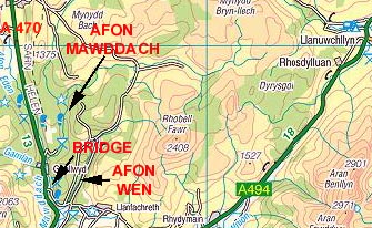 This map (produced from the Ordnance Survey Get-a-map service) shows the area particularly affected by the massive flash-flooding that struck in the mid-evening of July 3. When I say massive, I mean just that. There has been nothing like this in this area in living memory. The next page tries to depict the aftermath of this incredible event.... NEXT PAGE - THE GREAT FLOOD..... BACK TO WEATHER-BLOG MENU New! Fine Art Prints & digital images for sale- Welsh Weather & Dyfi Valley landscapes Slide-Library - Click HERE |
|