The
Tywyn Tornado, January 21, 1995
BACK TO WEATHER-BLOG MENU
New! Fine Art Prints & digital
images for sale-
Welsh Weather & Dyfi Valley landscapes Slide-Library
- Click HERE
One
of the most impressive weather events in Wales over the
past decade was this one, in which a strong tornado, with
a path 50 m wide and 4.3 km long, touched down just
outside Tywyn, N of Aberdyfi in Gwynedd, Wales.
Significant damage was done by the tornado, which rated
T4 on the TORRO scale or if you prefer, F-2+ on the
Fujita scale. Either way the winds that did the damage
are estimated to have been up to 135mph in strength!
The synoptic situation involved a low pressure system
centred between Iceland and N Scotland (980mb) at
midnight on the 21st and over N Scotland 24 hours later,
having deepened to 960mb by then. A frontal system was
occluding to the south of the parent low. The triple
point of the system appears to have passed through
Mid-Wales on the day in question. All of Wales was in a
run of strong to gale-force SW winds throughout this
period.
The tornado began life at about 11.30 am GMT, as a
waterspout over Cardigan Bay, according to locals I have
spoken to who recalled seeing it out to sea and
"never believing it would come ashore". But on
it came to make landfall. It appears to have been on-and
off the ground, however, with its chief damage area to
the NE of the town. Here there are two caravan sites and
scattered farms.
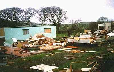
Typical tornadic damage - some caravans completely
destroyed while others, just out of the path, relatively
unscathed. Luckily again this occurred about as far away
from the holiday season as possible so that none were
occupied. One can imagine what would have been the result
if they had been.

Mangled almost beyond recognition.....

Nothing much left apart from a fridge!

This one captures the power of the tornado best for me -
big oaks snapped off like twigs. The one in the
background is said to have been 100 years old - it
certainly has a wide trunk. One can imagine the torque
applied by the vortex, taking the whole tree, twisting it
until it could no longer bear the incredible strain and -
crack! All in a second or so.
The
damage photographs were taken a few days after the event
by TORRO member Robin Harper, from Barmouth. Robin put a
notice in the local Cambrian News and received a few
responses, extracts from which are summarised as follows,
with the maps from GETAMAP for reference:
 |
 |

Gerllan:
One house damaged: "the TV aerial was ripped from
the chimney stack, three or four ridge tiles removed from
the roof"; wheelie-bin thrown "about 20
yards...." - local resident.
Hen-Dy:
"It happened at about 11.45 and passed over very
quickly. There was a teriffic noise and it lifted many
ridging tiles, slates & guttering from the house and
momentarily threw slates and tiles from the farm
buildings"... "I have never seen our dogs or
cats so frightened" - local resident.
Ysgyboriau:
"Around 60 caravans were wrecked, some flattened to
just a few inches. Four caravans are still missing"
; "There was a six foot high concrete shed situated
nearby that has been demolished as well and gas bottles
have been hurled hundreds of yards" - Cambrian
News/local resident in Cambrian News.
It was seen as "a white swirling cloud about 50
yards wide, and it hit the ground at the northern end of
the caravan site" - son-in-law of site owner in
Cambrian News.
"I believe that the only people to actually see it
were the site owners. Everybody else saw the huge
downpour of rain arriving around the same time. There is
some conflict as to the direction of the wind at the
time, but the rain apparently came down
from the valleys (my italics) -
North to South. I believe the whirlwind actually went in
the opposite direction" - local taxi driver.
One caravan owner wearily commented, on seeing his new
(10 days usage) £18,000 caravan flattened: "You
could say that it has cost me £1800 a night to stay
there" - Cambrian News.
Ynysmaengwyn:
"...eight large caravans overturned" - Cambrian
News.
Fields
towards Bryncrug:
"The bulk of the debris was spread between the two
sites and Bryncrug, a village about 1 mile north of the
sites" - local taxi driver.
Gwyddelfynydd:
Sometime "around 11.30am to nearest 15
minutes"; a "really strong southerly blast of
wind accompanied by rain/hail". Duration "about
30 secs". Damage: 2 trees down; 12-inch ridge tiles
and 19 x 12" slates off roof and up to 70m away in
field, picnic table lodged in apple tree, horse trailer
moved 30m across field and "the whole area strewn
with polystyrene, fibreglass and aluminium foil from the
caravan sites" - local resident.
Cil
Cemmaes:
Trees down/snapped off in woods, some caravan debris
noted - local resident.
Near
Bird Rock:
"What seems to have gone unreported, however, is
that a homeowner near Bird Rock found a large lump of
aluminium on their property" - local taxi driver.
Analysis:
Reports indicate that the tornado first touched down at
Gerllan on the outskirts of Tywyn. As it tracked NE from
here it appears to have intensified judging by
comparisons of reported damage at Gerllan and at the
caravan sites. It may well have lifted then but
definately made touchdown at Gwyddelfynydd, where it was
still powerful, and then on through the Cil Cemmaes
woods, though by then it had possibly weakened. It was
still, however, capable of carrying debris when it passed
Bird Rock, and is at present presumed to have dispersed
shortly beyond there, unless new information comes to
light.
The report of the "downpour coming south" from
the taxi driver is very interesting as the tornado was
moving north at the time. This may be indicative of a
more sizeable rotating system, including a tornado, that
I had previously thought may be the case. Clearly, the
reports suggest that at least some of the time the
tornado was rain- or possibly hail-wrapped.
The estimate of T4 damage was made by TORRO and was based
on damage photographs.
Interestingly some locals I have now spoken to have
mentioned two other tornadoes affecting roughly the same
area in the last 30 years or so. The search for more
information about these continues.
If anybody who saw/remembers this event is reading this,
I would be delighted to hear from them - click HERE to contact me by email!
Thanks to Robin for allowing use of his images and
collecting original accounts and also to Kevin Bradshaw
for additional synoptic information.
More to come soon hopefully so keep looking!
BACK TO WEATHER-BLOG MENU
New! Fine Art Prints & digital
images for sale-
Welsh Weather & Dyfi Valley landscapes Slide-Library
- Click HERE