A look at my most memorable experiences....
BACK
TO WEATHER-BLOG MENU
New!
Fine Art Prints & digital images for sale-
Welsh Weather
& Dyfi Valley landscapes Slide-Library - Click HERE
| Looking
back at the decade that is coming to an end, I thought I would make a
list of the ten most memorable experiences that I have had. It hasn't
been a straightforward task - the last ten years has been packed with
experiences - and emotions: a complete mixture of excitement,
frustration, satisfaction, fear, boredom.... if you want to get into
photographing extremes of weather then all of these may be expected
just for starters! I'm not going to list these in order of personal "wow" factor, but chronologically, for each has equal merits as an experience - it's just that the merits differ. Some were more photogenic than others, some more dramatic, some more peaceful.... if there's one thing they have in common it is that they all left me with an ever-greater appreciation, and at times awe, of the natural world, just in a small corner of the planet here in Mid-Wales. So we begin in 2000. I had watched "Twister" some years previously and had become a regular visitor to the websites of famous USA storm-chasers: it was time to give it a go myself! 2000: my first funnel-cloud Most years since I started photographing storms have delivered at least one "twister" - though so far not on the ground! But the best encounter is often the first and so it was in this case. I had learned how storms can be picked up on the rainfall radar online and had taught myself how to predict their likely track. On an August afternoon, on one of my first ever trips, I put what I had learned into practice - and hey presto! A superb and longlived funnel-cloud over the hills near Dylife, about 10 miles SE of Machynlleth. With an early success like that under my belt, I felt pretty unstoppable for a few days - though I soon realised how uncommon such sights are and I was back down to earth pretty quickly! 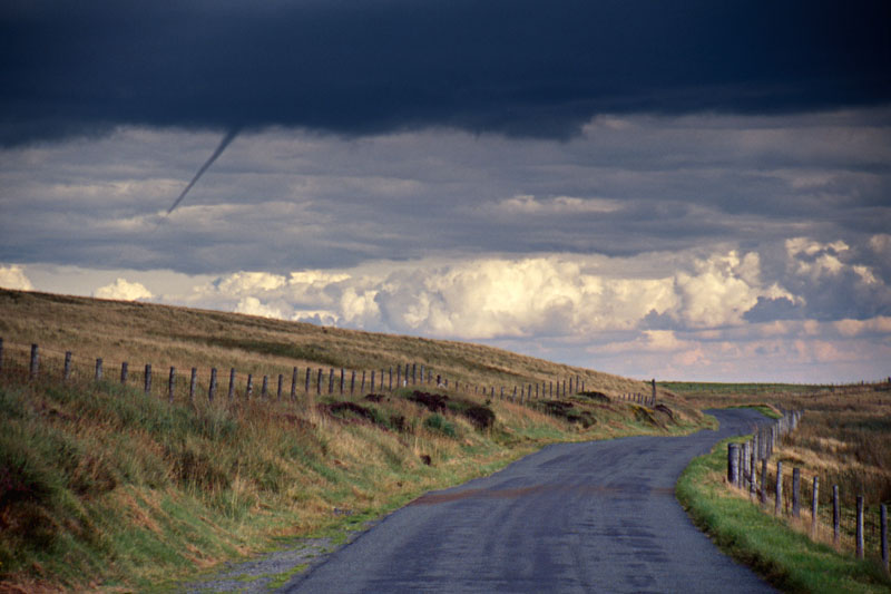 2001: exceptional flash-flood, Coed y Brenin If the thunderstorms of July 3rd 2001, with their large hail and vicious lightning, were impressive, they were beaten hands-down by the flash-flooding that followed them. Just a few hours' worth of torrential rain did this. The area between Dolgellau, Bala and Ffestiniog was hit by the flooding, and Afon Mawddach, in the Coed y Brenin forest, took the brunt. Here's a shot of the aftermath with debris wrapped solidly around a tree, with a man for scale! Locals spoke of a "30ft wall of water" coming down the river - this was the Boscastle that never made the papers! How much rain? We'll never know for sure. Comparable floods elsewhere have involved 200mm of rainfall - that's getting on for eight inches!  2003: thunderstorm clearance at sunset On the evening May 18th 2003 I followed a line of thunderstorms up over the mountains, not for a moment expecting what I was going to see as they cleared away eastwards. This incredible sheared anvil with mammatus is but one of many images taken that evening as dusk slowly fell over the mountains and silence replaced the lashing rain. The rainbow was present throughout! This still ranks as one of the most awe-inspiring things I have seen - it's going to take some beating!  2003: on location with BBC Wales! The same year, I was contacted by film-maker Nia Dryhurst with a view to putting together a documentary for BBC Wales on storm-chasing. Week after week of unexciting weather followed and things were getting tight until in mid-November a rapidly-developing Atlantic storm was forecasted so we went for that, arriving at high tide on the coast just as winds headed upwards of Storm Force 10, with lashing rain. We then spent several hours filming and getting wetter and wetter and colder and colder. We finished off at Aberdyfi where even in the sheltered estuary, boats were heaving violently! Over a very welcome large Scotch each in the pub on Aberdyfi's seafront, Nia told me that it was by far the worst conditions she had ever worked in. I wasn't going to argue!  2004: possible supercell over Llandinam, east Powys This storm, in August 2004, was caught in its developmental phase, forming on the outflow boundary of the mature storm to the left. The huge, smooth and striated tower had the appearance of many USA supercells I had seen on the web and, as shown in this ugly but interesting shot, all sorts was going on beneath the updraught base, including possible funnel-clouds. The storm continued to develop in this manner for several tens of minutes as I sat and watched, utterly fascinated, from my vantage-point across the valley. It finally rained-out and the resultant gust-front raced so fast across the countryside that it had reached the top of the mountain road, several miles to the west, at the same time as I did! 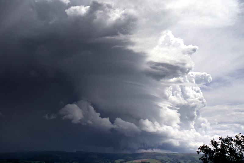 2005: early-morning storm rendevous, Borth Late November 2005 saw a cold, unstable Northerly airflow become established over the UK. Sometimes, in such circumstances, an almost stationary line of thunderstorms can develop down across Cardigan Bay, clipping the St Davids peninsula of SW Wales and running down towards SW England. The met-slang term "Pembrokeshire Dangler" has been coined for such a set-up. Thunderstorms form and run down the line one after another - this "Dangler" gave 6" of snow in Pembrokeshire, where a lad sledging was struck by lightning. I made a pre-dawn intercept and watched as the rising sun beautifully illuminated the rock-hard thunderheads along the line: of the many photos taken this was my favourite. It was amazing to watch as the whole thing evolved through time, although given how cold it was, I was glad to be home for breakfast well before 9! 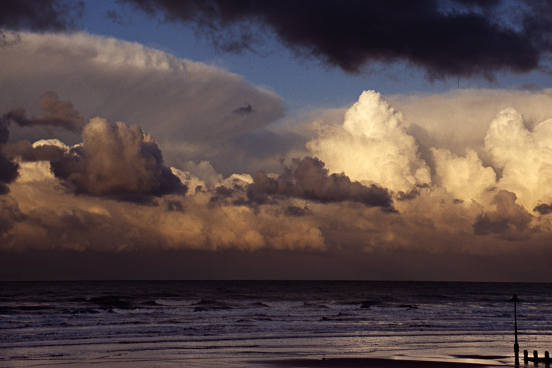 2006: the Bow Street Tornado Early on a November morning in 2006, the phone rang: it was BBC Wales asking if I had heard about the tornado that had done lots of damage at Bow Street, a village on the way to Aberystwyth. I hadn't, but was on my way, I replied. The day was spent mapping the damage track and assessing the strength of the twister, which was estimated to have been an F-2 (113-157 mph) tornado. TV interviews were done on and off, some live, during an intense and lengthy day as I wandered along the track photographing the destruction for my report to the Tornado & Storm Research Organisation (TORRO). The scene below quite stopped me in my tracks. Dusk was approaching; in the background a fluffy white cumulonimbus thunderhead - harmless-looking but the sort of cloud that can spawn tornadoes - whilst in the foreground we have part of a caravan and a wire fence wrapped around swings in a childrens' playground. Had the swings been in use at the time.... 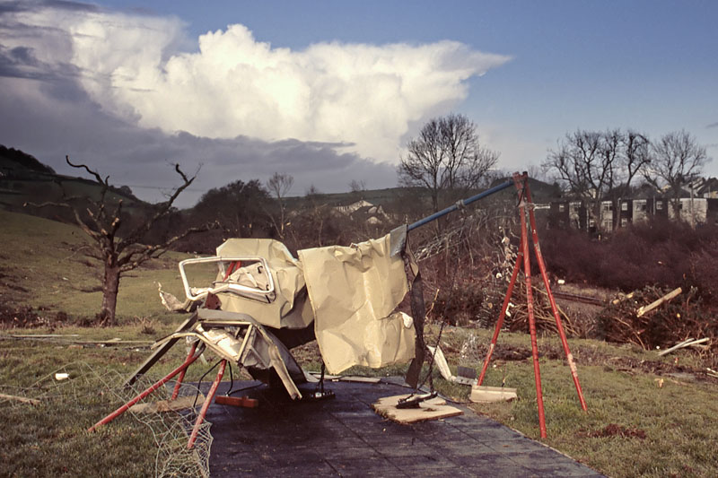 2006: a truly psychedelic sunrise! Just two days after the Bow Street tornado, I woke early to notice a strange glow to the east, although here it was still dark. I grabbed my gear and headed out to Machynlleth golf course, on the road to Forge, and stood gobsmacked! The sky was a sheet of stratocumulus, from which small mammatus clouds hung, and as the sun rose it underlit the whole lot with every shade of pink, red, orange and yellow imagineable. In a layby close to where I was stood with my beanbag tripod on a post there was a wagon parked up and the driver was too engrossed in his tabloid paper to look up and see this! For about fifteen crazy minutes I shot images, until the sun rose above the cloud-deck and the vista faded out to grey. I have never seen anything like this, before or since. 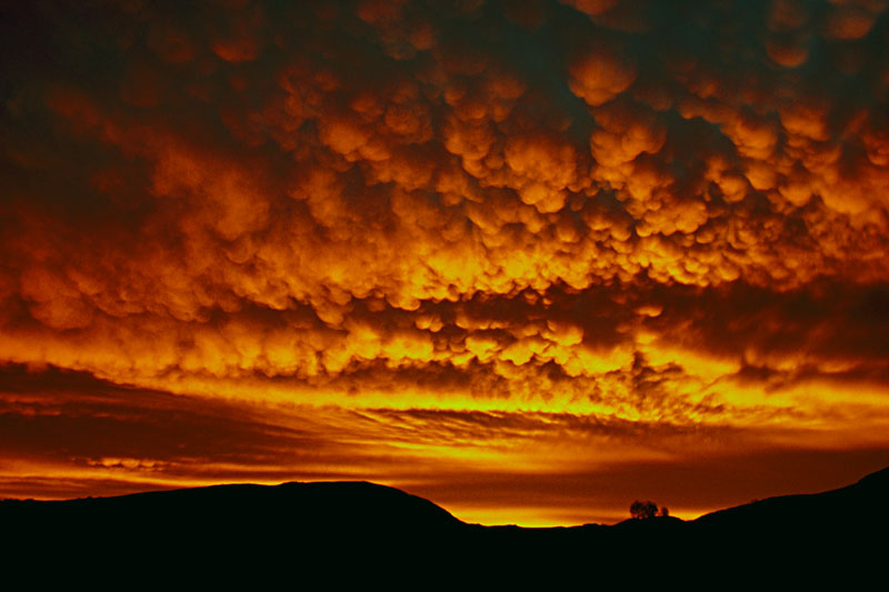 2007-8: a winter of huge waves The winter of 2007-8 was marked not by snow (there was some) but by a series of powerful Atlantic storms, generating huge swells that broke against the coast. Several trips stand out - a December sortie to the St Govans area of Pembrokeshire, this one in January to Aberystwyth and a further one to the same place in March where a monster storm-surge occurred. Out of the myriad images obtained, this was my favourite. Giant waves vary in their interaction with the coast - it depends on how they are interfered with by the backwash from previous waves - and timing is everything. In this case, Nature got it right and my timing was OK! The greyness suggests rain and that was indeed ongoing, to complicate matters - you have to use a Skylight filter to keep the delicate surface of the lens dry, and be prepared to dry it out with tissues in between shots. The results can justify the trouble taken - as I hope this shows! 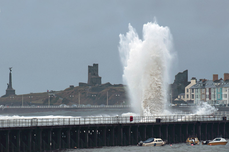 2009: noctilucent clouds Noctilucent - or more correctly Polar Mesospheric - clouds exist right at the edge of space, ~80km up at the top of the Mesosphere. A onetime rare phenomenon - first described in the months following the 1883 eruption of Krakatoa - they are becoming a more and more frequent sight in the hours after dusk and before dawn in the midsummer months. Why? We don't know. Research is ongoing. The mystery that surrounds them adds to the sense of awe on seeing a good display! Like the Aurora, these clouds require two independent parameters to be satisfied for a successful photography session: a) they need to be there and b) skies otherwise need to have little or no cloud. In the lousy summers of late the second parameter has been the big problem: the first has been satisfied many times. Nothing more frustrating than seeing the familiar electric-blue glow through a chink in the almost unbroken cloud! On July 20th I once again set the alarm for 0300, and this time was successful - although some lowlevel cloud is apparent in the image below, the "noctis' are very evident with their delicate networks and ripples. This was my favourite from the shoot which I did from Machynlleth golf course, where some higher ground gives a view uncluttered by buildings and overhead cables.  You
will have noticed some years missing from the above - that's extreme
weather photography for you. Such events are like the proverbial buses:
you go for ages with nothing much occurring, then all of a sudden you
are inundated with stuff to shoot! Will 2010 onwards beat any of these
for me? No, because every weather photograph represents a unique event,
a frozen moment of captured time in Earth's dynamic, never resting
atmosphere. You cannot improve upon something that is unique - all you
can work on is your photographic technique! The journey goes on.....
|
|
BACK TO WEATHER-BLOG MENU New! Fine Art Prints & digital images for sale- Welsh Weather & Dyfi Valley landscapes Slide-Library - Click HERE |