AUTUMN 2006 -
part 5: The Bow Street Tornado
BACK TO WEATHER-BLOG MENU
New!
Fine Art Prints & digital images for sale-
Welsh Weather & Dyfi Valley landscapes Slide-Library - Click HERE
INTRODUCTION
- THERE'S NO SUCH THING AS A "MINI-TORNADO"!
 |
Getting
up on the morning of Tuesday 28th November 2006 I found there were two
messages on the answerphone. Funny I thought, seeing as it's before
9am. One was from Tony Gilbert, Site Investigations Coordinator for
TORRO (the Tornado & Storm Research Organisation) and the other was
from Carl Yapp from BBC Wales. Both indicated the same thing - the
sooner I could get over to Bow Street the better. There had been a
tornado in the night and a site investigation was needed. I should at this point explain why TORRO undertakes site investigations. When a severe and damaging wind, of whatever type, strikes an area then it will create damage patterns specific to the type of wind and its intensity. In order to figure out our changing climate, the more we can look into each extreme weather event and understand it, the better. A TORRO site investigator, then, is a meteorological forensic detective. He or she will map out and record the damage, take photographs and interview witnesses and the data collected will then enable conclusions to be drawn regarding the event type and its power. |
Each event can then be entered onto TORRO's ongoing database and
statistical examination of patterns of occurence may, in years to come,
be able to tell us whether any trends are emerging.
The investigation quickly confirmed that a tornado had indeed tracked
through Bow Street, with ferocious and damaging winds of over 130mph. A
perfectly natural, if unusual event, and so you will not see either
"freak" or "mini-tornado" used anywhere in the account below. The
latter term, coined by the media, is grossly misleading: it implies a
harmless whirl, like a summer dust-devil. The Bow Street event was
nothing of the kind: it was a violent and potentially lethal vortex
over 50m in width.
 THE
WEATHER AT THE TIME THE
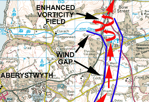
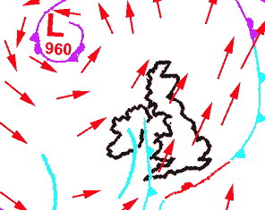
WEATHER AT THE TIMELet's have a look at the weather on the night of the 27th-28th. Here is a sketch of the synoptic situation at midnight. A deep Atlantic low sits out to the NW of the UK, with south-westerly winds (red arrows) over Wales. Just to the west there lies a cold front (pale blue), with a trough (blue line) following on behind. Earlier in the day there had been heavy showers and I witnessed a thunderstorm not far from Tywyn, up the coast from Aberdyfi. Further activity was forecast overnight. 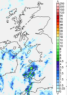 Now
let's look at the rainfall radar (from Netweather, an excellent subscription service),
for 0100 on Tuesday 28th. The cold front is clearly marked out by a
line of rain stretching from Cornwall across the Bristol Channel and up
across western Wales. Now
let's look at the rainfall radar (from Netweather, an excellent subscription service),
for 0100 on Tuesday 28th. The cold front is clearly marked out by a
line of rain stretching from Cornwall across the Bristol Channel and up
across western Wales.Within the general wet weather (blues and greens) there can be seen local bright areas (yellows and reds). These indicate torrential downpours (anything over 20mm/hr is "stair-rods"!), which in turn tell us that within the cold front there are embedded convective cells - heavy showers and thunderstorms. Wherever convection occurs, there exist vigorous upward air-currents - the updraughts that lift warm moist air high into the convective cumulonimbus cloud. And if, for a variety of possible reasons, the air rising into the cloud starts to rotate, or corkscrew upwards, then there exists the risk of a tornado forming. Sudden updraught intensification (i.e. a massive jump in the speed of the upward air-currents within the cloud) will tighten that rotation down into a narrow but very rapidly spinning column of air, which may extend down from the cloudbase all the way to the ground. We now have a tornado. THE TORNADO TRACK..... Let us now examine the path of the Bow Street Tornado, and see what it can tell us about itself. |
||||||||||||||||||||||||||||||||||||||||||||||||||||||
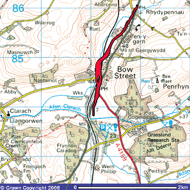
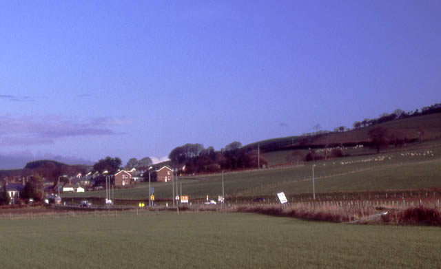 One part of a TORRO site-investigation is to try to determine the length of the tornado track on the ground. Here is the first evidence, on the A487 south of Bow Street. Speed-limit signs have been blown over; the nearest one has been completely uprooted despite being anchored in a large mass of concrete. In the opposite direction, towards Aberystwyth, is the railway with trees on its embankment. Scanning these with binoculars revealed no damage: therefore, the first touchdown must have been between the railway and these road-signs. |
||||||||||||||||||||||||||||||||||||||||||||||||||||||
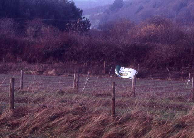 The tornado continued along the main road, destroying this road-sign in the process and flinging part of it towards the railway... |
||||||||||||||||||||||||||||||||||||||||||||||||||||||
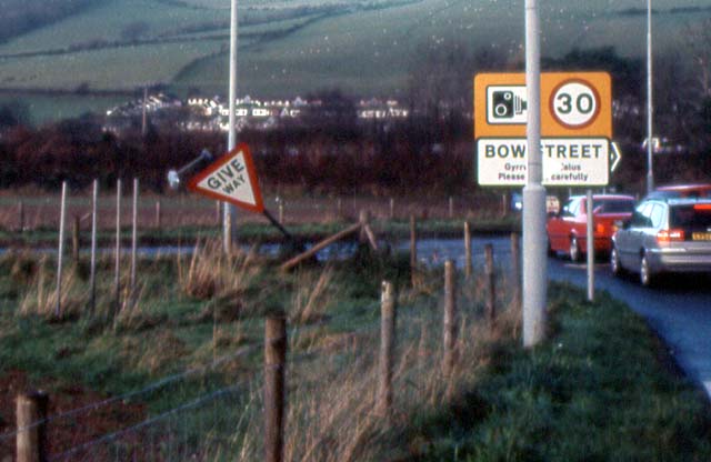 Give way? Indeed it has done so. This is the A487/A4159 junction. Note the "Bow Street" sign is undamaged - this area must have been close to the edge of the vortex... |
||||||||||||||||||||||||||||||||||||||||||||||||||||||
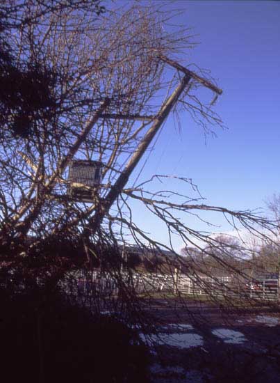 Beyond the junction lies a builders yard with some trees to its S. The tornado affected both, indications being that it had veered slightly L here. Eyewitnesses reported bright flashes without thunder: these were power-flashes as utility poles were toppled sending live cables snaking and sparking about on the ground.... |
||||||||||||||||||||||||||||||||||||||||||||||||||||||
 This large Scots Pine stood just N of the utility pole (above) and was summarily uprooted.... |
||||||||||||||||||||||||||||||||||||||||||||||||||||||
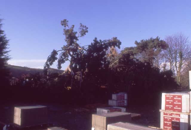
 The tornado at this point was wide enough to uproot trees alongside the main road and also to damage this building at the builders yard, removing parts of its roof and its shutter-doors... |
||||||||||||||||||||||||||||||||||||||||||||||||||||||
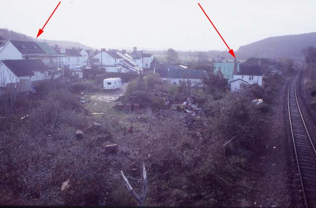 Beyond the builders yard are houses and the pub - the Welsh Black. Here, there were eyewitnesses, awoken by the noise (variously described as a train crash or a plane crash or simply a teriffic roaring) and the bangs and crashes of their properties being mauled. All reported torrential rain after the tornado passed. Pub manager Darren Davies, 24, said: “I thought a lorry had gone through a house. It was deafening. I looked out the window and it was raining bricks. It was like an action movie.” He said a 4x4 was lifted 20 yards across the pub car park. (source: Sun newspaper) The arrows in this photo, taken several days after the event (when roof tarpaulins better mark badly damaged properties) indicates the tornado width here. It had also clipped a few properties along the main road opposite the Welsh Black. The caravan in the image was rolled on its side. The worst damage was to the house with the tarpaulin (L) where that portion of the roof was removed in its entirety. Numerous chimney-stacks were felled. And, in a feature typical of many tornadoes, other properties escaped relatively unscathed. Tornado damage can be surprisingly fickle in its nature... |
||||||||||||||||||||||||||||||||||||||||||||||||||||||
 Here is a typical example, where the main track is L of the railway. There is no damage apparent to the trees R of the railway, yet where the red arrow is a powerful blast of wind has scattered items about and felled a tree. This may be evidence for a multi-vortex event i.e. more than one twister within a larger, parent circulation.... |
||||||||||||||||||||||||||||||||||||||||||||||||||||||
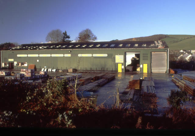
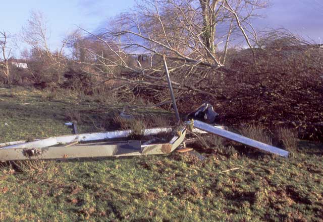
 The tornado was at its full fury as it crossed the railway bridge on the B-road to Clarach. Heavy capping-stones were dislodged from the bridge: it is not known whether this was achieved by wind alone or by heavy airborne missiles. On the other side is a car dealership. The roof was torn off the building R and a large Portakabin that would normally have been in the foreground here was levitated in its entirety. Beyond there is severe tree damage alongside the railway... |
||||||||||||||||||||||||||||||||||||||||||||||||||||||
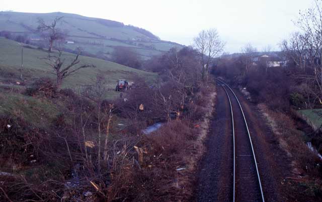 Another shot looking N up the railway a few days later, with the clear-up well underway. The path of the tornado across the railway and into the field beyond is clearly evident. Its RHS is demarked by the intact trees beginning again; within the path the majority of trees have been destroyed... |
||||||||||||||||||||||||||||||||||||||||||||||||||||||
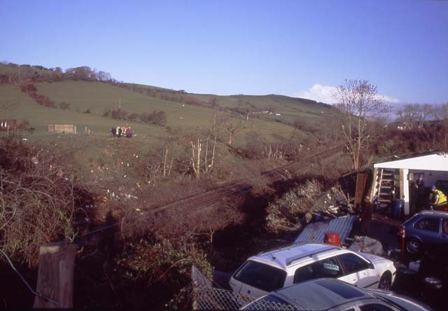
 Looking over the railway into the fields beyond on the morning itself, residents survey the damage. By now, people were searching for car-keys that had been stored in the Portakabin. Many have since been found, all credit to the villagers... |
||||||||||||||||||||||||||||||||||||||||||||||||||||||
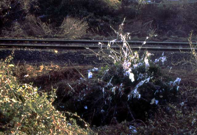 Down by the railway, this tree is decorated with shredded paper.... |
||||||||||||||||||||||||||||||||||||||||||||||||||||||
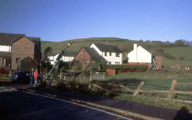 Over the bridge and along the road a little, a lamp-post lies bent over, the fence is flattened and builders are checking for and repairing roof damage to the houses beyond. To their R lies a small playground... |
||||||||||||||||||||||||||||||||||||||||||||||||||||||
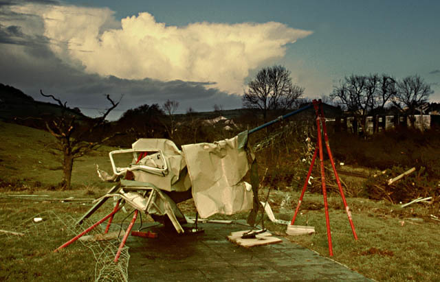
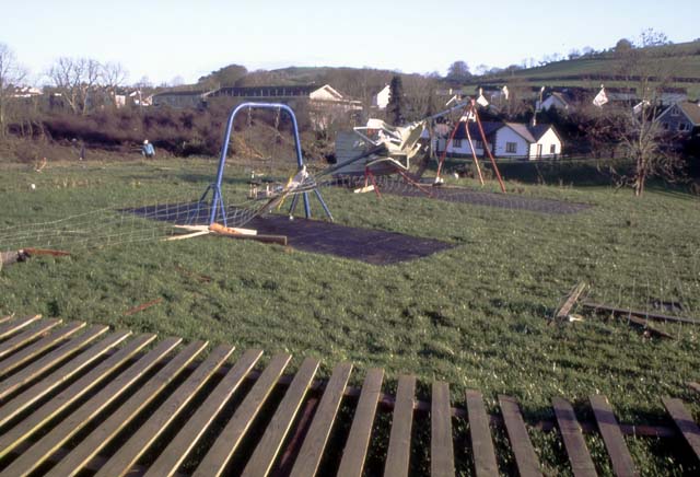 The playground was surrounded by wooden and mesh fences, both of which were destroyed. But the swings in the distance have been affected particularly badly... |
||||||||||||||||||||||||||||||||||||||||||||||||||||||
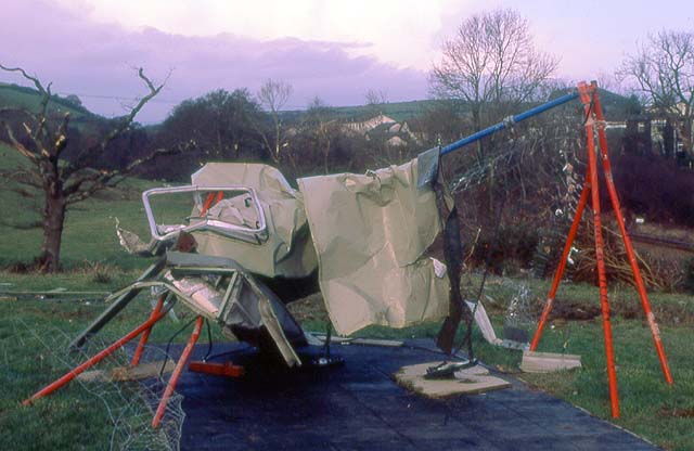 This is part of the Portakabin from the garage. Mangled almost beyond recognition, it has flown over the railway, been folded over the swings and is jammed there quite solidly. This is serious damage.... |
||||||||||||||||||||||||||||||||||||||||||||||||||||||
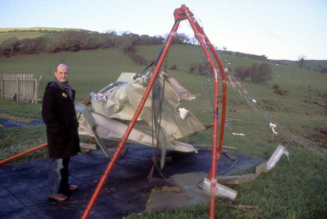 Another shot with Carl Yapp of BBC Wales. Note how the mesh fence has somehow become wrapped around the swings (RHS of image)... |
||||||||||||||||||||||||||||||||||||||||||||||||||||||
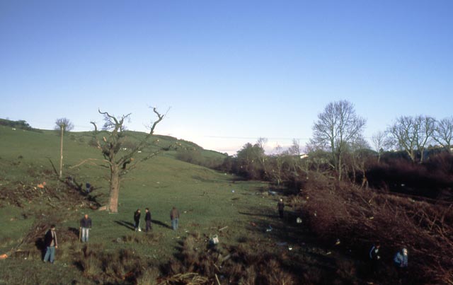
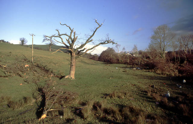 From the swings looking along the tornado track to the north. General tree destruction in the distance and this and the next oak in the field are badly debranched. Here is a vital clue. The windfield before and after the tornado would have meant that the wind would have blown from SW-NE - bottom L to top R in this image. The oak in the foreground has had its broken branches thrown to the left - or westwards, against the prevailing wind. Most tornadoes spin cyclonically, or anticlockwise. When this one was passing through, therefore, on its leading edge the winds would have been blowing from R to L. As it passed over, there would have been a brief calm, before furious winds from L to R set in, marking its rear flank. That oak has clearly been struck by the leading edge of the tornado and its branches thrown accordingly: clear evidence that tornadic, and not other high winds, had occurred. |
||||||||||||||||||||||||||||||||||||||||||||||||||||||
 This photo was taken straight into the sun so it's not too good. It shows the second oak in the previous image and on the ground nearby lies the heavy sheet steel-clad Portakabin door, having flown through the air for over 400 metres.... |
||||||||||||||||||||||||||||||||||||||||||||||||||||||
 Back down and along the brook a little way, here is another piece of Portakabin... |
||||||||||||||||||||||||||||||||||||||||||||||||||||||
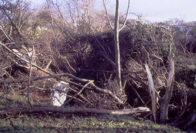 Further along again, the mangled trees and items of large debris track the tornado's course... |
||||||||||||||||||||||||||||||||||||||||||||||||||||||
 At this point, it is clear that the tornado veered a little to the NE, crossing the brook. It then took a course through several housing estates, causing locally heavy damage to rooves, garage doors, sheds and greenhouses: mercifully, however, by now it was diminishing in its strength... |
||||||||||||||||||||||||||||||||||||||||||||||||||||||
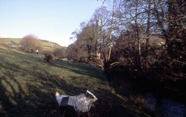
 Between Bow Street and Rhydypennau two large fields span the distance between the A487 and the brook, and at their northern end I found this rolled-up mass of sheet-metal (beyond my jeep, that is!). This came from the garage with the Portakabin and seems to represent the last piece of large debris from there - thanks to Eric Ellis-Jones for emailing me that info! It has therefore travelled, presumably entirely in the air, for just over a kilometre! This street, Maes Ceiro, saw the northernmost serious structural damage. I am indebted to Elwyn Owen for the following notes: "Our house has a flat roof and at 1.18am on THE night it (ie the whole roof not just the felt) was almost blown off. In fact half the roof is off and, according to a builder , the other half would also have been off were it not for the chimney stack wedging it down. A similar damage occurred next door and another house will have to be gutted because the felt roof came off. The roof was "made safe" temporarily by bracketing it down and the 60-70 mph wind on the following days hardly moved it which just goes to show the strength of the wind on THE night. The "bang" as it hit the house was unbelievable." EYEWITNESS - THE AMBULANCE DRIVER'S EXPERIENCE The last bit of structural damage I could identify was to a house in the estate opposite Rhydypennau School. However the tornado was still on the ground by the Rhydypennau Inn. This we know from an eyewitness account from an Machynlleth ambulanceman I interviewed. He was taking a patient into the hospital at Aberystwyth on that night. Approaching Bow Street from Talybont, he noted flashes in the distance which he, quite reasonably, took to be lightning. However, on approaching the Rhydypennau Inn, the vehicle met the tornado head-on. "I can only describe it as driving into a black tidal-wave", he told me. "You literally could not see a thing ahead and I had to stop". A dustbin flew by from L to R and lots of small debris struck the vehicle, which was rocking from side to side. All the time this was going on there was blinding horizontal rain. Then, after what had seemed an eternity, but was probably only about 15 seconds, it passed. The ambulance then continued towards Aberystwyth, having to carefully negotiate bricks, tiles and other debris all over the road in the southern part of the village. The crew put out an immediate call to Control, warning them to expect casualties. They arrived in Aberystwyth shortly before 1.30am. Earlier in their journey it had been necessary to stop and administer assistance to the patient, resulting in a delay of a few minutes to their journey. Had that not occurred, they could have met the tornado at the other end of Bow Street, where it was at its most savage. Fate had spared them that ordeal. The tornado must have dissolved away shortly after the ambulance incident, but lighter debris, lofted up into the storm-cloud, remained, kept in the air by the storm's updraughts. Bit by bit it fell to ground: I tracked paper and fragments of corrugated plastic as far as Talybont, and more recently some paperwork from the garage has been found in Corris, near Machynlleth and almost 20 miles to the NE! HOW LONG AND HOW STRONG? - ASSESSING THE DATA
The most intense
damage was from the road junction to the Welsh Black Inn, on to the
garage where it was particularly wild, and into the playground and
fields beyond. This I would rate as T4. Beyond that as it veered into
the housing estates E of the brook, it dropped quickly, doing T3, T2
and T1 damage until it dissipated somewhere N of the Rhydypennau Inn.
It was probably at low T1 intensity where the ambulance met it.
|
||||||||||||||||||||||||||||||||||||||||||||||||||||||
BACK TO WEATHER-BLOG MENU New! Fine Art Prints & digital images for sale- Welsh Weather & Dyfi Valley landscapes Slide-Library - Click HERE |