WINTER 2007-8
part 6: Significant windstorm, March 10th 2008? The outcome.
BACK TO WEATHER-BLOG MENU
New!
Fine Art Prints & digital images for sale-
Welsh Weather & Dyfi Valley landscapes Slide-Library - Click HERE
After writing up the
Sunday 9th of March update in the lead-up to the storm I headed over to
Borth for low tide, the aim being to get a few photos of the "Fossil
Forest" since the light was especially good. It was a beautiful
afternoon down there with the peat-beds and stumps well-exposed between
Borth and Ynyslas:
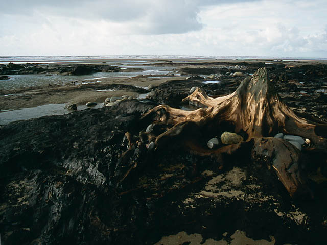 However, not long after arriving there a cloud that had been building up over the bay moved over me and gave a short downpour of heavy rain and little hailstones. I was thoroughly drenched and the cameras went quickly back into the bag. But afterwards, the sun came out and the reflections on the rain-drenched sand were beautiful: 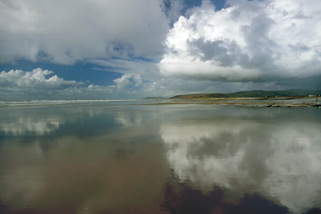 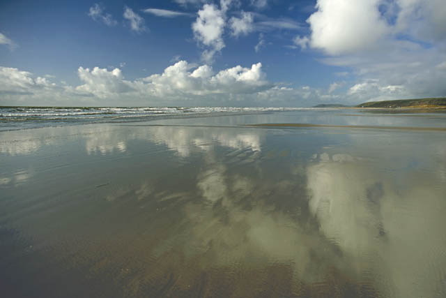 ....and as the water drained away, ripple-marks on the sand made eyecatching patterns: 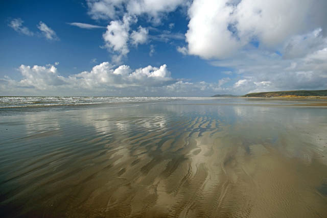 Just twelve hours later the storm would be moving in! I got up just before 0300 on Monday 10th March with heavy rain and gusty winds lashing the street outside. Observations and travel reports confirmed the worst of these winds were hitting southern areas with an 82mph gust recorded at Mumbles in South Wales and roads blocked by fallen trees in most counties south of a line from Fishguard to Dover. The low was crossing central Ireland and, with again a slightly more southern track, its centre was heading straight towards Mid-Wales. The winds accompanying the cold front eased by first light and I got ready to head to Aberystwyth, leaving just before 0730 with a view to avoid the morning traffic which can be bad. By 0800 I was set up in a layby looking NW over the Harbour and its outer breakwaters. Although the wind had dropped to just a force 4-5, the ground-swell was big and I became absorbed in shooting images of the huge waves that were breaking over the end of the Prom: 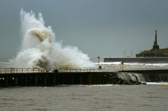 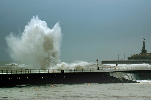 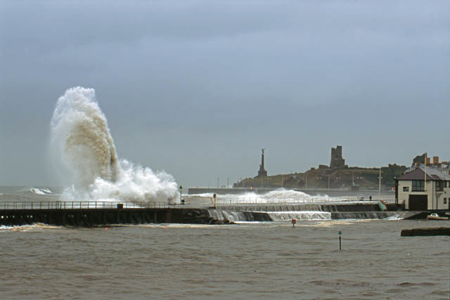 As high water approached, the Prom became deserted as the police wisely closed it. The tide rose and rose until it was less than a foot off the top of the Town Quay whilst water cascaded over the Prom into the Harbour: 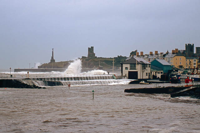 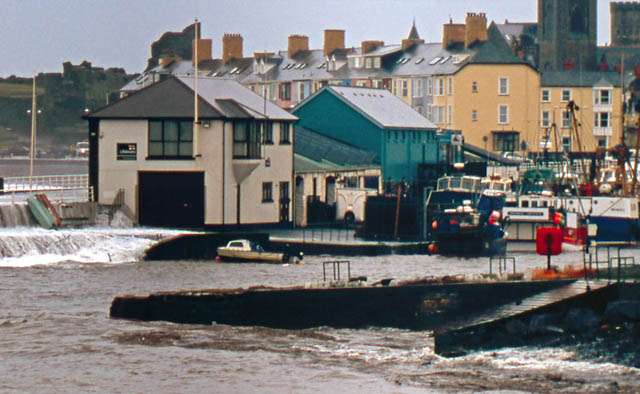 Note the red boat below - and then again in the next image... 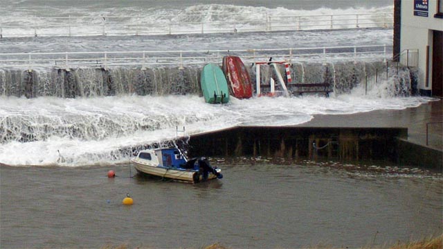 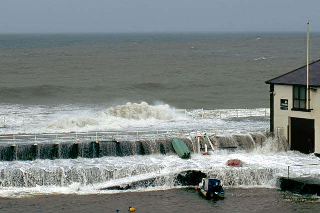 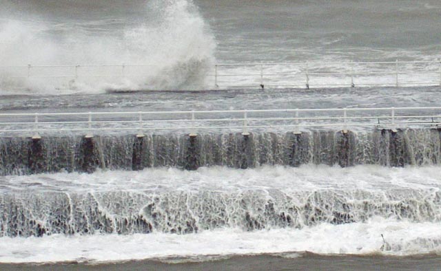 The unusual water height in the Harbour is evidence for the storm-surge that accompanied this system. A storm-surge is basically an extensive bulge of water that forms offshore under the centre of a cyclonic storm, whether tropical or extratropical. Water-levels in this bulge are built up by two factors - sustained strong winds and the low air pressure. They can result in higher-than-usual tides especially if the timing of the low pressure system moving through and high tide are coincidental. I then headed out of Aberystwyth to Borth, finding a couple of vantage points below the War Memorial on Borth Head that faced north - away from the heavy rain showers that were getting going again. Again the scene was spectacular, but because I was some distance away, the shots needed a telephoto lens: 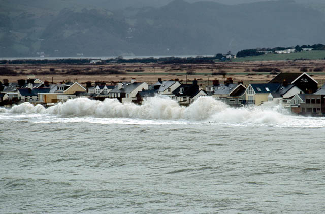 What was weird was the lack of wind as the centre of the low started to move in! The sea had an unruffled appearance but huge rollers were breaking against the sea-defences. Imagine if there had been a force 11 gale behind these waves, as there would have been had last Thursday's GFS forecast runs been correct with the low tracking much further north! Severe structural damage and flooding would almost certainly have resulted. 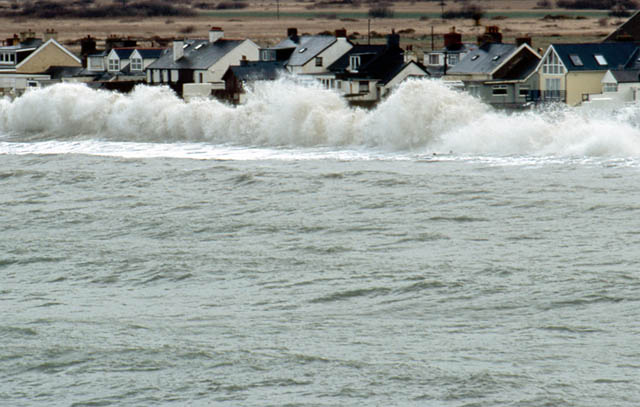 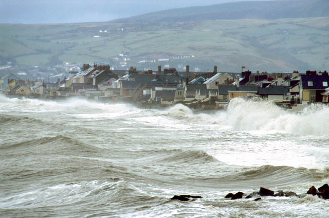 I left Borth and headed home, stopping on the way to photograph the Leri estuary and then the Dyfi at Glandyfi. Both had extremely high water levels, not far off those seen in the Burns' Day Storm. The Leri is in the photograph below: it is contained in a levee-like embankment here and the water level is a good couple of metres above the land around, out of sight to the L of the field of view. The crossing in the distance is the Cambrian Coast line. Some years ago, the LH bank here breached, causing extensive flooding. 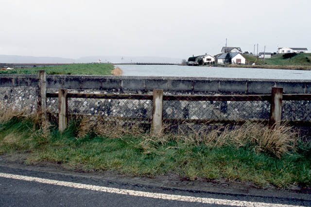 After getting some food down me I headed back out to the coast at lunchtime and, on the hills above Borth, basked in warm sunshine with blue skies overhead and absolute calm, despite the angry-looking dark grey shower clouds that occupied the sky in all directions. This really was the "eye of the storm" - not a true eye as hurricanes have, but the calm conditions indicated I was very close to the centre of the low. Back in Aber, the Prom was open and I had a drive along it: 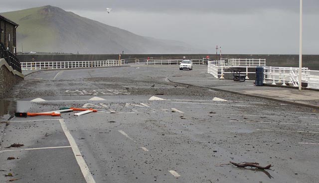 Some debris but I have seen a lot worse! Another storm of almost comparable strength went on to affect more northern areas of England and Wales and S Scotland/Northern Ireland overnight on Tuesday 11th and into Wednesday 12th March, but the tidal cycle had peaked and the severe damage threat to coastal communities had receded. No comfort, however, to the molluscan inhabitants of the underwater sandbanks off Borth Beach, as I found on a beachcombing trip on the following Thursday: 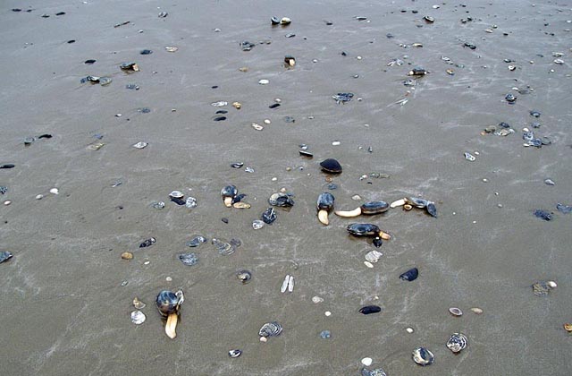 Hundreds of bivalves had been ripped up out of their seabed burrows and were strewn all over the beach, particularly these sand-gapers (Mya sp.) and the more rounded Arctica (pretty much in the middle of the above pic). Here's a close-up showing their shells broken or damaged in many cases.... 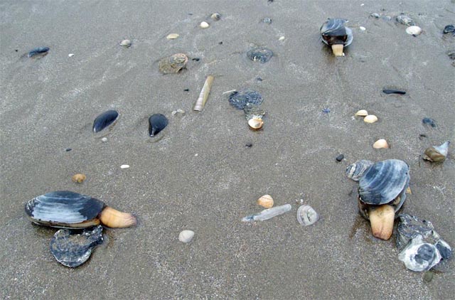 Seabirds were there in droves, tearing into the defenceless clams. By the time I arrived hundreds had been eaten or part-eaten (below) but I rescued a few for the freezer (they make good baits for bass) - share & share alike! 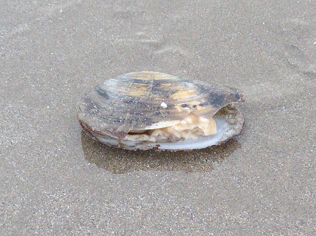 The flotsam that came ashore was staggering and unfortunately most of it was smashed although I picked out a couple of serviceable fish-boxes (below) and even found a fishing-rod tangled in a mass of old netting - apart from needing a couple of rings it appears to be serviceable! 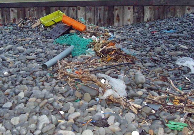 |
|
In the
aftermath of these storms, I mused on what a close escape this had
been. If the original,
more developmental scenario as
suggested by the GFS on Thursday 6th
March: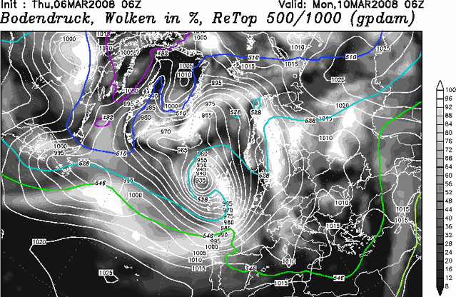 |
|
had occurred, with the centre of the Low much further north, that abnormal high tide would have been accompanied by severe gale or storm-force westerly winds. The result would have been utter chaos, with major flooding of low-lying coastal communities in Mid-Wales. Watching how the forecast models have handled this storm has been a fascinating exercise. Small changes in upper air patterns affected the low's timing, the point at which it started to fill and its track. All were predicted fairly well: by Sunday it was clear that what actually happened on Monday was pretty much going to happen. The significant coastal flooding was restricted mostly to SW England and the Channel Islands. I hope these two pages serve to demonstrate how weather forecasts involving severe storms evolve in the days that lead up to the event. Forecasting involves applying scientific principles to a natural system in which many variables are intereacting to produce the final outcome. Often, these variables can fluctuate in a subtle manner independantly of one another, but these subtle fluctuations can have a significant effect on that outcome. The charts produced by each successive run of model output reflect attempts to address how such variables are interacting: in turn this explains why forecasts are updated on a daily basis, any why anybody doing activities that are weather-dependant has to follow these updates carefully in order to obtain an accurate picture of what is going to happen. |
|
BACK TO WEATHER-BLOG MENU New! Fine Art Prints & digital images for sale- Welsh Weather & Dyfi Valley landscapes Slide-Library - Click HERE |