On July 5th 2001 I drove up to
Ganllwyd on the Afon Mawddach and was so astonished by
the chaotic damage that several trips were made during
the following weeks to survey the event's aftermath.
Graham Hall from Coleg Meirion Dwyfor and Bob Chilton
from Capel Hermon also contributed images to this page. |
|
 A mass of broken trees and branches is jammed under the bridge... |
|
 Looking upstream over the debris - note the swathe of mangled bankside vegetation on the R. |
|
 There was a "tidemark" on the tarmac, and in the hedge, just past the far end, so the river had actually risen over the bridge itself! A bit of tape-measure work established that the water level had been 5.4m above normal here. This image shows the railings, which were badly dented where floating trees had banged into them... |
|
 Above Ganllwyd the river flows through the Coed Y Brenin Forest, along a number of narrow gorges interspersed with wider, gentler sections. In one such gorge the river turns a bend: here the bank had been stripped up to 10m above normal water-level. In this image a surviving conifer tree, high on the bank, has a debris-wrap of smaller trees and branches. Halfway up on the L stands Alun Pugh (6ft tall), to give an idea of scale! |
|
 Close-up of the debris-wrap above. Alun on L. |
|
 Here's a self-portrait! I'm stood 2m above normal water-level with another debris-wrap high above me! |
|
 This is the stone bridge just below the old Gwynfynydd Gold Mine, looking downstream. Obviously badly damaged and again plastered with trees and other debris. Photo: Bob Chilton. |
|
 And again, looking upstream, some days later after the debris has been removed. This bridge is well over 100 years old: the arch has stood the incredible pressure well but the river has gone over the top and stripped the rest of the stonework away... |
|
 This is the road-bridge over the Afon Gain - gone! Note how far above the river the span was and the water-washed grass in the foreground! Photo: Graham Hall. |
|
 This is one of the main forest roads: the river's fury has swept half of it clean away.... |
|
 The back-road from Bronaber to Capel Hermon crosses both the Mawddach and Gain headwaters and bridge damage was again severe - the road was closed for a time afterwards while bailey-bridges were put in. Photo: Graham Hall. |
|
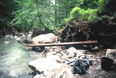 The Afon Wen is a smaller tributory of the Mawddach but again the destruction was widespread. Boulders >10 tons in weight had been chucked about; log-jams I have known of for years had vanished; a sturdy footbridge had utterly disappeared and one of its 5m steel girders was found, badly bent, 400m downstream. It had successfully negotiated 2 gorges, a waterfall and a deep pool to arrive here..... If there is one lingering memory, apart from the sheer awe, of the storm's aftermath then it must be the sweet, aromatic smell of the thousands of pulverised, debarked conifers. It hung above the water for days on end and evoked sudden, catastrophic change - a whole landscape altered for ever in only an hour or two! |
|
So: how much rain fell to do all of this? We know that the storm responsible tracked NE over the area between the Rhinogs and the Arans, and looking at the damage patterns it must have intensified over Rhobell Fawr and northwards. The area sees impressive floods most years, and there was a bad summer flood in 1995 which resulted from rainfall totals of up to 95mm overnight. But the damaged caused then - impressive though it was - was nothing compared to this. The Centre for Alternative Technology, between Dolgellau and Machynlleth, recorded 3 1/2 inches of rain during the July 3 storm. A local from Capel Hermon, further up the Afon Wen, spoke of "3 1/2 inches of rain in 3 hours". But what fell over the mountains where a lot of the floodwaters originated from? We may never accurately know: all that is clear is that a flood event perhaps unparalleled in the last century overtook these quiet and peaceful valleys on July 3rd, 2001. |
|
| BACK TO WEATHER-BLOG MENU New! Fine Art Prints & digital images for sale- Welsh Weather & Dyfi Valley landscapes Slide-Library - Click HERE |