SUMMER
2005 - PART 3:
Tornado near Cardigan, 27th August 2005
BACK TO WEATHER-BLOG MENU
New! Fine Art Prints & digital
images for sale-
Welsh Weather & Dyfi Valley landscapes Slide-Library
- Click HERE
On August 30th I received an email
with an excellent attached photo (below) from Leona Ralph
of Milford Haven asking whether anyone else had seen a
tornado near Cardigan on Saturday August 27th at around
3pm.
Someone had! The remarkable sequence of images below was
taken by Rosemary Brabrook of Cardigan. They show the
complete evolution and decay of a small but still
impressive tornado. Congratulations to Rosemary, who was
in the right place at the right time, something we
storm-chasers always try to do - but not always
successfully. I'll try and explain a bit more about
hunting tornadoes and finding out more below.
 On the day in question, major convective activity was not forecast. The high-resolution radar (above) showed a scattering of modest convective showers across the UK. The red arrow points to Cardigan. This radar is available by subscription from www.net-weather.co.uk and I can recommend it at less than twenty quid a year for the basic package (which includes a very useful zoom-in tool). The other packages include a lot of useful forecasting data. The radar updates every 15 minutes which with the zoom tool gives you a very good look at what's developing! Under such conditions one might not expect tornadoes, but they can in fact occur with any type of convective cloud if the right conditions are prevailing. Big, damaging tornadoes, however, are associated with the strong convective updraughts of the type associated with much heavier storms.  The charts for that day showed high pressure over Europe ridging west with low pressure in the N Atlantic and also to our SW. A moderate westerly airflow covered Wales. It was clear at the coast, as seen in the above image, taken looking away from the convection, towards the Teifi Estuary, Gwbert and Cardigan Island, which implies that local sea-breezes had set in. The clear air's a dead giveaway for this. In this area the coastline runs NE-SW, which means that a breeze coming in from the sea would be from the NW. This would have caused convergence of air inland (the prevailing westerly plus the NW sea-breeze). Such conditions are supportive of convection and the attendant wind-shear (wind changing direction with height - i.e. NW at surface, W 1000ft up) would have been favourable to the occurrence of localised rotating updraughts which can spawn funnel-clouds and tornadoes, even if the updraughts are weak and the resultant tornadoes non-damaging. |
|
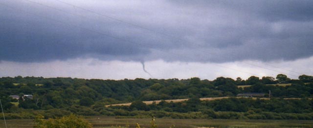
 This sets the scene for Rosemary's sighting. I have zoomed right in for the subsequent images. Here, a small funnel-cloud is visible between the two houses. It is protruding from a dark rain-free cloudbase, although rain (and reported hail) can be seen falling further to the left. An important point if you are looking for tornadoes is illustrated here. If you have located a convective shower or storm, concentrate on the rain-free part of the cloudbase. This marks the updraught region of the convective cell and is where any funnels are likely to develop if the conditions are favourable. A funnel-cloud is formed because the air quickly being drawn into a rotating updraught from its surroundings experiences a sudden fall in pressure and temperature. The moisture it contains then condenses as a result, forming cloud. |
|
 Zoomed-in, we can already see that the vortex has in fact extended down and is close to or on the ground..... |
|
 Now, the whole funnel has thickened which in basic terms can be taken as a sign that it has strengthened a little. It would have probably been causing localised gusty winds on the ground by now, but as it's a weak tornado it is unlikely that any noteworthy damage would have occurred.... |
|
 Here it appears to have lifted off the ground again.... |
|
 Weakening a little, its lower part is now a little thicker than its middle section... |
|
 Changing again - this all happens rapidly in many such cases.... |
|
 Now in its death-throes, it has taken on a decidedly convoluted appearance... |
|
 A major loop has now formed in the funnel.... |
|
 Here the loop has moved around - twisting with the twister if you like - giving it the appearance of a knotted rope.... |
|
 Here the top of the funnel seems to be disengaging with the parent cloud. It'll all be over soon.... |
|
 Starting to dissipate.... |
|
 Cloud breaking up.... |
|
 And gone, except for a trail of fragmented scud-cloud, which outside of the rotating updraught environment will now evaporate again. |
|
 Rosemary and her husband then got into their car and headed for a better vantage point. They were rewarded with a second unusual lowering of cloud, which can be seen in the centre of this image. Hail is falling to the left. |
|
 Here it is seen closer-up. It was rotating again, but does not have the neat, ordered appearance of the earlier sighting. A lot of fragmented scud-cloud is forming and been drawn up into the cloudbase. |
|
 Very low cloudbase-lowering - probably a ragged condensation-funnel. There appears to be a small piece of airborne debris associated with the lowest part.... |
|
 An apparent smooth funnel has formed in this image (LHS of lowering).... |
|
 This whole area of the cloudbase has upward and probably rotating air-currents.... |
|
 Close-up again - the funnel-like feature is still present on the L... |
|
 In this final shot the whole mass is retreating gradually into the distance. Although not newsworthy in the sense that the Birmingham tornado of July 28th 2005 was, this is still an interesting and illuminating series of images. The principles of tornado formation are the same here as in the Birmingham disaster: in this case the updraught was weak, being associated with a weak convective shower, and thus the tornado that it produced was weak and short-lived: in the case of Birmingham, a very powerful rotating updraught associated with a violent thunderstorm produced a strong tornado with a damaging track of several miles and a longer still track as a funnel-cloud. Events like the Birmingham tornado are thankfully uncommon in the UK and can be many years between in occurrence. Less powerful but damaging ones happen every year in a variety of weather setups. They can occur at any time of year and the number we experience has increased in recent years. Some say that this is due to climate change but there is another reason too. There are far more people interested in the weather these days - it's in the news all the time after all. There are also many more people able to capture events such as this due to the proliferation of digital and mobile phone cameras. Even so, many more must go missed, especially in sparsely-populated regions. TORRO - the Tornado and Storm Research Organisation - both forecasts and records tornadoes. Its staff and members visit the sites of tornado damage and use a number of methods to classify tornadoes on a scale of 0 to 10. The Birmingham tornado was a T4-5, while the above example was probably T0 in intensity, with winds of 39-54 mph. Thankfully, a T10 (an astounding and terrifying 270-299 mph) would be an exceptionally rare event, as it would have the power to obliterate everything in its path. If you are interested in finding out more about TORRO, visit its website at www.torro.org.uk. Anybody interested in joining the organisation can find out more by emailing membership@torro.org.uk. We have an active online members' Forum where all aspects of severe weather, its forecasting, its aftermath and its photography are discussed. The membership ranges from people new to the subject to professional weather forecasters and a great deal of knowledge is exchanged on a daily basis. Thanks again to Leona Ralph and Rosemary Brabrook for their contributions. |
|
BACK TO WEATHER-BLOG MENU New! Fine Art Prints & digital images for sale- Welsh Weather & Dyfi Valley landscapes Slide-Library - Click HERE |