BACK TO WEATHER-BLOG MENU
New! Fine Art Prints & digital images for sale-
Welsh Weather & Dyfi Valley landscapes Slide-Library - Click HEREE
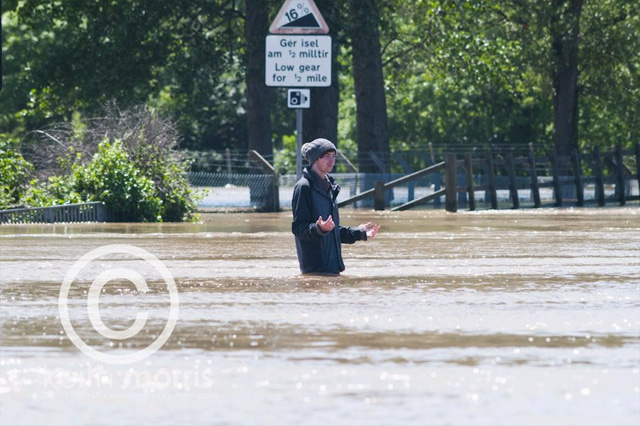
June 10th 2012: this is a bit of a collaborative post with Aberystwyth-based photographer Keith Morris to whom I am grateful for permission to use some of his images as between us we got to where we could in order to record an extraordinary severe weather event that affected a fairly small part of Mid-Wales from the early hours of Saturday June 9th onwards.
Rain set in on the night of June 7-8 as a deep area of low pressure off the SW of England moved NE straight across Wales, bringing severe gales especially to the south-western coastal areas during the 8th. The low had moved off into the North Sea by the evening of the 8th but its trailing occluded front continued to sit over Mid-Wales overnight before finally drifting off northwards later on the 9th. The rain finally died out late morning on the 9th, almost 36 hours after it started. The area affected is shown by the map below; place-names are in black and river-names are in blue:

Topographically-speaking, the land rises quite quickly from the coast to the Cambrian Mountains at around 500-600 metres above sea-level, and the highest point in the area is Plynlimon at 752m.
Below are radar screengrabs from Netweather. I have a full sequence of these but will just post four (they all look very similar) - one from 1400 on the 8th, one from six, then twelve and then eighteen hours later - the latter one being just as the rain began to slacken in its intensity.
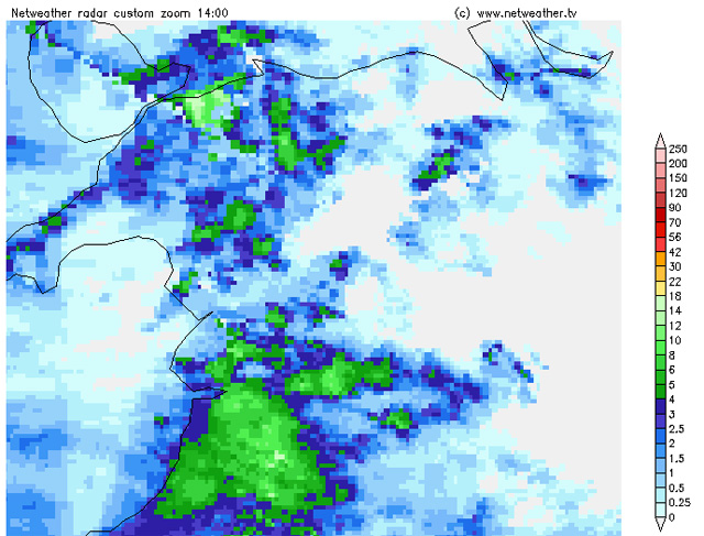
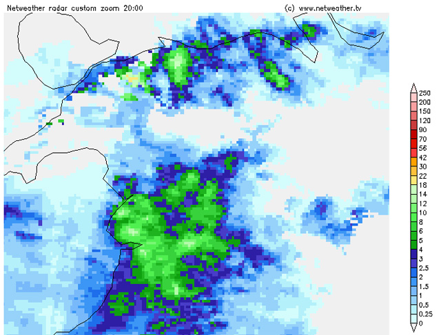
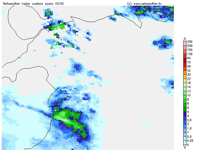

There are two important points in these images: firstly that whilst the rain is light over the sea it peps up as the westerly airflow comes inland and up over the Cambrian Mountains, then fizzles out further east, towards the lower ground of East Wales, and secondly the rainfall-rate over the high ground, at over 10mm/hour, hour after hour after hour. This is a classic example of orographically-enhanced rainfall. The "quick-and-dirty" diagram below shows what happens:
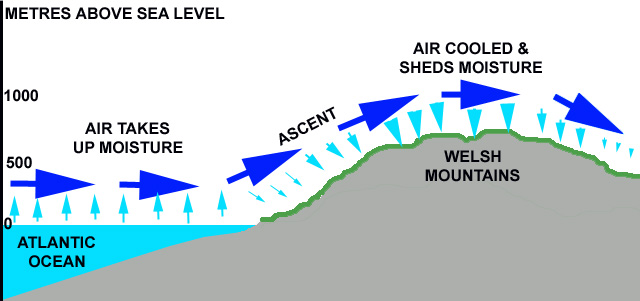
Air moving across the Atlantic and the Irish Sea picks up moisture as it evaporates from the sea surface. The temperature of the air is critical here, because for each extra degree Celsius, an airmass can carry 7% additional water-vapour. This is a well-known relationship that was first described during the 19th century, and incidentally it is one of the major concerns with respect to global warming because it means that rainfalls of greater and greater intensity will occur as it gets warmer and warmer.
The inverse in the same relationship occurs when the air moves inland and is forced to rise over high ground like the Cambrian Mountains. As it rises, the air cools and loses much of its ability to carry the water-vapour which then falls out of the clouds as heavy rain (largest pale blue arrows). As the air descends down off the Welsh hills towards England, it warms up again and thus the rainfall peters out, as the radar images show. Hence the term "rain-shadow" - a relatively dry area downwind from a mountain-range. The mountains get most of the rain whilst the ground downwind only gets a fraction of it.
So with a stationary frontal feature bringing a continual warm moist airflow plus orographic enhancement, the scene was set for a deluge. How much rain? Trawscoed, which was a bit to the south of the most intense rain-area, had 78mm in the 48 hours up to 1800 on the 8th. Pant recorded 120mm. However, the key area from which data are required is around the western upslopes of the Plynlimon range. Here, the radar data suggest a period of over 24 hours during which rain was falling at over 10mm/hr, with a possible 240mm or more as an "event total". 240mm is, of course, almost ten inches. Perhaps this explains the unprecedented chaos that occurred as a consequence.
It should be noted that 4-5 inch (100-125mm) rainfalls might sound like an awful lot but they are by no means unusual in these hills, especially during winter "warm conveyor" set-ups: they produce the big Dyfi Valley floods that occur every winter and have been featured on this site many times before - and yet such flooding is nowhere near as bad as that of June 9th 2012. That key observation in itself suggests a much greater amount was involved. I'll update on this point if I get any better data*. The only falls in recent years that may be comparable are 261mm from a warm-conveyor setup at Capel Curig on Feb 2-3 2004 and of course the great July 3 2001 deluge that affected the area north of Dolgellau - though this was a convective flash-flood caused by a severe thunderstorm, on a similar scale to the famous Boscastle Flood, which in rainfall terms is a different kettle of fish.
******************************************
* Update: EA raingauge totals are in good agreement with the estimates above with Dinas, near Ponterwyd, recording 183mm. However, the following daily rain total maps, based on cumulative radar-plots from Netweather, add some more detail. I've enlarged the Mid-Wales area in the top LH corner. For friday:
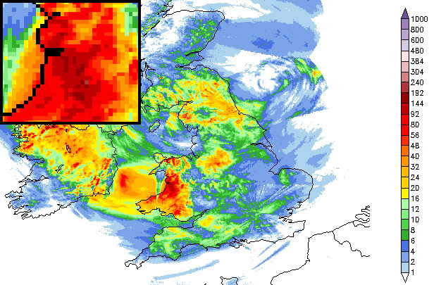
We can see that a large area received 92-144mm, but that locally there was 144-192mm. For Saturday:
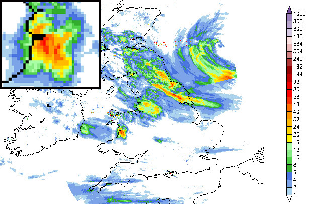
We can see that a further 48-56mm of rain fell on the western upslopes of the Cambrian Mountains. Put together, these plots show that over 150mm (six inches) fell quite widely but locally event-totals reached 200-250mm (eight to ten inches).
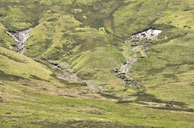
The image below, taken early the following month, shows an effect of ground saturation: bog-burst landslides on the northern flanks of the Plynlimon massif. Unfortunately there are no sheep for scale but the RH area would be about the size of a tennis-court.
******************************************
The Dyfi catchment was only half-affected, with the rain falling onto its southern side whilst the major mountains of its northern side such as the Arans massif received relatively little. Even so, the Dyfi rose to within 30cm of its all-time recorded high of 4.03m. On the Saturday morning, having caught up on the news of rescues and multiple evacuations, I climbed up the Wylfa above Machynlleth in still-falling rain to see what I could see: the roads in and out of town to the north and south were closed to all traffic so the pedestrian approach seemed the only option...

The sun even peeped out for a bit:
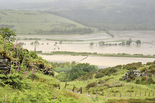
From the top, the view down the valley was as dramatic as I have ever seen it:
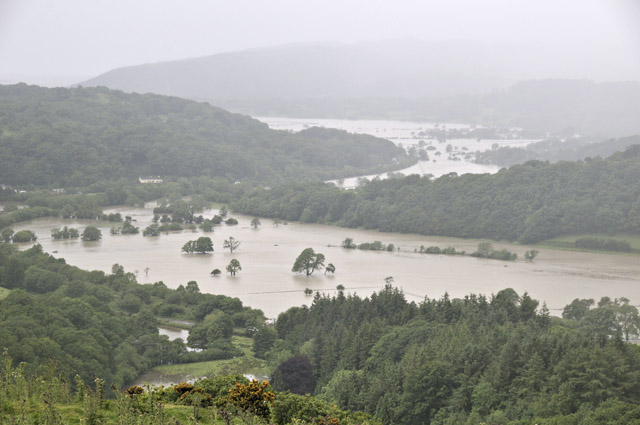
That afternoon, with water-levels at Dyfi Bridge dropping quickly, and further investigations warranted, I drove south along the main road that heads to Talybont and Aberystwyth, but this notorious spot near Derwenlas presented an impassible obstacle....

There are two or three back-roads that miss this blackspot. The first one I tried was a no-no. Note the fallen tree in the distance...

This one was passable - just. The river on the right is the usual one: the one on the left is the road I've just come down. Knowing that the run-off would continue to decrease with time, I pressed on...
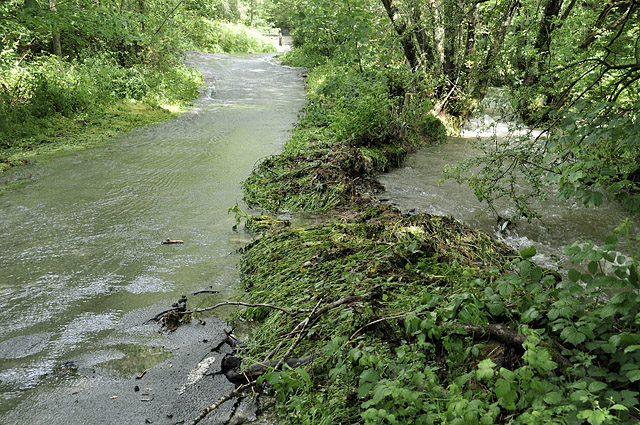
From Glaspwll back down to the A487, the main problem was side-streams washing debris-cones onto the road. I would not have tried this field-trip without a 4x4....
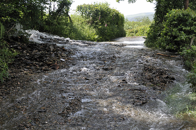
Here stood back a bit, with the jeep for scale....
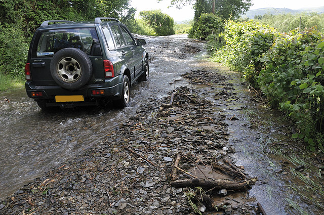
Onto the A487 and this was the worst bit, a little south of Eglwysfach with masses of rocks having been washed down, although elsewhere some deep water sections had to be negotiated dead slow....
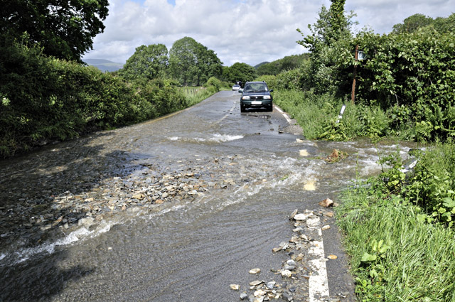
This was looking up the Leri at Talybont. Two rivers join in the village: the Leri is the bigger and its tributary is the Ceulan, normally a smallish brook. A large shed from somewhere upstream has run aground in the back garden of one of the worst-flooded properties...
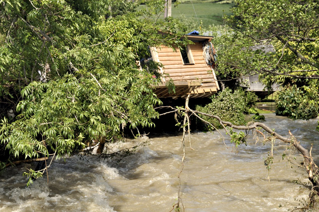
We switch here to images obtained early that morning by Keith Morris, who was able to get to Talybont when it was impossible for me. This was close to the height of the flood:
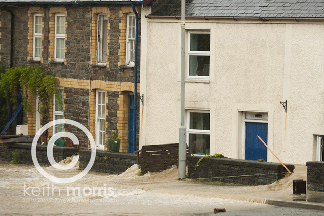
This image shows the Ceulan having burst its banks behind the White Lion and, flowing across the beer garden and car-park, it has joined the Leri in the middle of the Village Green:

Finally an overall view:
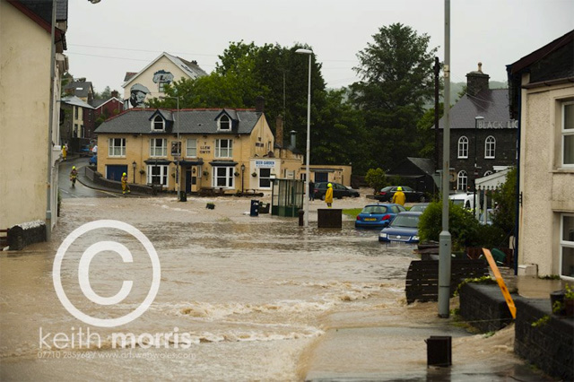
I lived in Talybont in the 1980s through into the 90s and did not once see anything remotely close to this. Talking with locals yesterday, the last time the Green flooded was in 1963 and some say that a large tree becoming jammed under the bridge had a lot to do with that incident. In the 1990s the bridge was enlarged with a wider span.
On this occasion the water was out across the valley-floor upstream and apparently burst into the backs of the worst-affected properties, where feet of water were surging through. The devastation left behind is what one would expect....

By the time I could get there, the waters had receded and a major clearing-up operation was underway, with areas of ripped-up road-surface being removed and villagers coming together to help those worst affected...

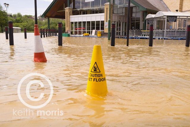
Much of the TV footage concerned rescue-missions at caravan-parks in riverside meadows further downstream near the small villages of Llandre and Dolybont, where helicopters were deployed to winch some people out of harm's way. However, during Saturday the lag-time in water flowing down the rather longer Rheidol valley was evident and with high tide at 1300 ponding-in this water, large areas of the Retail Park at Aberystwyth were flooded - as evidenced by this shot of Morrison's supermarket, again by Keith Morris:
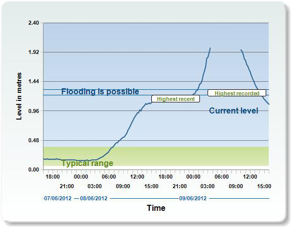
The images show that a major event took place, but this graph does it for me. It's an EA river-gauge on the Leri at Dolybont. One can see both the highest recent and the highest recorded levels are marked, but for a time early on June 9th 2012, the readings are, quite literally, off the scale!
Still more images:
BBC Wales with some shots taken at the peak of the floods in Talybont and Dolybont:
http://www.bbc.co.uk/news/uk-wales-18384493
Keith Morris Facebook gallery including some shots inside homes in Talybont:
http://www.facebook.com/media/set/?set=a.10150962496119850.446748.512799849&type=1
Guardian with shots taken around Machynlleth and at the caravan-parks:
http://www.guardian.co.uk/uk/gallery/2012/jun/10/wales-flooding-in-pictures#/?picture=391374855&index=0
Stunning video of the flood in Talybont by Ifan Lewis:
http://www.youtube.com/watch?feature=player_embedded&v=O6UiJlygWdM
RAF Search & Rescue mission video:
http://www.walesonline.co.uk/2012/06/09/raf-search-and-rescue-launch-rescue-operation-in-mid-wales-91466-31148689/
My thoughts are with those whose lives have been so disrupted by this exceptional event.
BACK TO WEATHER-BLOG MENU
New! Fine Art Prints & digital images for sale-
Welsh Weather & Dyfi Valley landscapes Slide-Library - Click HERE