STORM-CHASING
IN WALES - THE THEORY!
BACK
TO WEATHER-BLOG MENU
New! Fine
Art Prints & digital images for sale-
Welsh Weather & Dyfi Valley
landscapes Slide-Library - Click HERE
Thundery
weather in Mid-Wales can be classified
into three general categories:
1) Low-pressure systems drifting N/NE
from the Bay of Biscay & N France,
declining High over N Britain, late
April-late September.
These produce big summer storms on
occasion although conditions are often
poor for photography. Often, large areas
of thundery rain result, the skies are
grey and visibility can best be desrcibed
as murky. Lightning can be spectacular if
such systems pass through during
night-time.
2) Slack summer (mainly July-August)
low-pressure over Britain with strong
onshore breezesThese
systems are less frequent but often
provide superb opportunities for
photography, as well-developed lines of
cumulonimbus generation persist over
favourable areas. In Wales, these often
form in a N-S convergence line along its
border with England. Clear skies and
well-defined cloud structures are the
order of the day -such storms are
slow-moving and often they have developed
by mid-morning and then last into the
evening, with regeneration taking place
repeatedly.
3) Unstable airflows from SW, W or NW
associated with Atlantic depressions, all
year around
Atlantic depressions are a strong feature
of Welsh weather, occurring all year
round, but most vigorously October-March,
when winds can gust to over 100mph on
occasion. Heavy showers occur following
the passage of the cold front, feeding in
off the Irish Sea. Squally winds and
rattling lentil-sized hail are the usual
mixture in with the rain but on occasion
things get a bit more impressive, with
cumulonimbus development along
well-defined squall-lines, mammatus cloud
on the undersides of anvils and plenty of
lightning. A SW force 5 wind seems to
generate good conditions, particularly in
the Spring and Autumn: in winter a
Nor-westerly sometimes brings thundery
snow showers. Clear air and excellent
cloud structures are typical, the showers
fast-moving but frequent.
PLANNING
THE CHASE: KNOWING YOUR PATCH AND GETTING
THE ESSENTIAL DATA
Following and photographing storms in the
Welsh hills is a challenging occuptation.
Good vantage points combined with safe
places to stop are not that common. There
are very few roads where you can simply
stop the minute you see something good!
The best plan is to get to know the
layout of your usual chase area on
non-storm days, noting places where you
can safely stop and that command
extensive views. Make mental notes of
these as they will be important target
points on a stormy day!
Basic TV and radio forecasts will alert
you to the possibilities. Look out for
"rain, followed by brighter, showery
weather" for instance. But you will
have to pin down the activity a bit more
for results.
For storm formation, convection is
required - the process by which warm,
moist masses (or parcels) of air are able
to rise up into cold, drier air. In such
conditions the water vapour condenses out
as water droplets or ice crystals -
clouds. As these particles start to fall
back earthwards due to gravity,
precipitation in the form of rain or hail
occurs. The vertical transport of heat
and moisture sets up an updraght, while
the gusty winds that accompany the rain
from a convective cloud are known as
downdraughts. The stronger the updraught,
the longer the water and ice particles
will be kept in the cloud and the heavier
the consequent shower will be. But the
important thing is to work out where -
and when - active convection leading to
shower or storm development will occur.
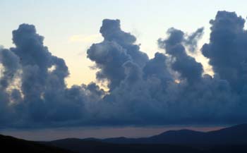 |
(L): A good sign that serious
convection is underway is when
ordinary cumulus clouds start to
take on a "towering"
appearance. Such development, if
it continues unchecked, can lead
to cumulonimbus formation - the
classic thundercloud! |
Data can readily be
found on the Internet. The BBC and Met
Office weather sites give the basics.
Firstly, learn how to interpret synoptic
charts. Then, there are more specialised
data sources that are important to check
when forecasting convective activity. See
my LINKS page to access essential
forecasting data. Two important datasets
of particular interest to storm-chasers
are the CAPE and the Lifted Index:
CAPE (Convectively
Available Potential Energy)
This is measured in Joules per Kilogram
of air (J/Kg) and defines how much energy
is available or released by a rising
parcel of air between 1000hpa and 500hpa.
It is an important tool in forecasting
the likelihood of thunderstorms. Values
of more than zero are indicative of
instability (necessary for convection).
Other factors have to be taken into
account though! If CAPE values exceed
1000J/Kg then severe thunderstorms are
probable, but even values of >100 can
produce results!
LI (Lifted Index)
The Lifted Index is a value calculated by
subtracting an air parcel's temperature
from the temperature of the surrounding
air into which it has risen, giving a
value in ºC. If the Lifted Index is less
than zero (eg. -2), it indicates the
parcel is warmer than the air into which
it has risen. Hot air rises: therefore a
negative Lifted Index shows that the air
parcel still has buoyancy. In such
unstable conditions, showers and
thunderstorms are more likely. Very low
Lifted Index values (-5 or less) are rare
over the UK and are indicative of
conditions in which severe thunderstorms
may develop.
Both CAPE and Lifted Index values are
plotted as overlays on maps of the UK.
They are generally updated every 6 hours
and the updates must be checked as the
new plots will be based on more recent
data!
Rainfall radar is useful when combined
with satellite images and sferics plots -
the latter being plots of the location
and rate of lightning strikes. These are
updated more frequently, at least hourly,
and can allow you to pinpoint where a
storm currently is and, importantly,
where it is heading. Ideally the thing to
look for is an isolated heavy storm with
clear areas nearby, permitting good
chances of photographing cloud structure.
CHASE TACTICS FOR
PHOTOGRAPHERS
If storm cells are fast-moving (99% of
the time this means that they are bowling
along on a strong SW round to NW
airflow), then don't try to keep up with
them (by driving like a maniac and
risking your and other folk's lives) but
try to meet them head-on. The Mid-Wales
coast allows superb extensive views both
seaward and back towards the mountains in
many areas, so that it is a natural
choice in such setups. You can photograph
an approaching storm, move a little to
the N or S to avoid the core and then
retrace your steps to photograph it again
as it retreats away - which is a prime
time for mammatus-clouds, backlit by the
sun (hopefully).
Because the best storms in photographic
terms are usually fast-movers in a brisk
westerly-quadrant wind, what was a
fantastic sight when you stopped the car
may have disappeared by the time you have
set up your tripod, changed lenses, taken
light readings etc. Learn to take
photographs by hand without getting
camera-shake! Use medium-fast film like
100-200 ASA so that the exposures are
fast and take several shots if something
looks really good - it improves the
chance of getting one really good one. If
a storm is slow-moving, that's when you
can take your time with photography.
Finally, if lightning bolts are crashing
all around you, stay in your vehicle!
Remember that the best chances for good
photographs are not in the middle of a
storm but to one side of it. The
precipitation cores of big storms are
also dangerous due to high winds and
standing water on the roads and are
places to avoid - or, if passing through
them, places for extremely cautious
driving, especially bearing in mind that
some other road-users may not understand
or appreciate the hazards.
BACK
TO WEATHER-BLOG MENU
New! Fine
Art Prints & digital images for sale-
Welsh Weather & Dyfi Valley
landscapes Slide-Library - Click HERE
|