A ROUGH GUIDE TO THE UPPER AIR
BACK TO WEATHER-BLOG MENU
New! Fine Art Prints & digital images for sale-
Welsh Weather & Dyfi Valley landscapes Slide-Library - Click HERE
This used to confuse me greatly so I have spent a lot of time reading it up and thought I'd throw together this rough guide!
We live at the bottom of a "soup" of gases, constantly moving in all directions - our atmosphere. The bit we see most of is the lowest part, where our weather goes on, but the weather-charts as seen on BBC forecasts show only what is happening close to the surface. The actual forecasts themselves are made with much reference to goings-on aloft, in what we call the upper air. So let's have a look at it:
BASICS: THE TROPOSPHERE
Virtually all of our tangible weather (excluding occasional, very high cirrus-clouds) goes on in the lowest major division of our atmosphere, the Troposphere. This varies in thickness from about 8000m over the poles to 17000m over the tropical seas - in other words, it's thinnest in cold areas and thickest in hot areas. Likewise it fluctuates in thickness on a seasonal basis according to whether it's warmer or colder. Above it lies the Stratosphere, while below it lies the surface of the Earth. The junction with the Stratosphere is known as the Tropopause.
 |
The troposphere can be divided into two sections, the upper layer, known as the Free Atmosphere, and the lower, or Planetary Boundary Layer. The Boundary Layer usually runs up from the surface to about 1000m above it (sometimes more, sometimes less) but in any case it's a relatively thin layer in which the air movements and temperatures are influenced not only by major weather patterns but also by localised effects relating to the interaction of the air with the planet's surface. |
These localised effects in the Boundary Layer include
frictional drag as winds cross land areas, eddies and
veering due to hills and headlands, convection initiated
directly by heat radiation from sun-warmed ground,
heat-radiation from warm sea water and so on. These
factors are all forcing mechanisms that set air currents
in motion, such as the thermals enjoyed by birds and
glider-pilots alike.
Above the Boundary Layer, winds are directed by the
Coriolis Effect working in conjunction with
pressure-gradients. The Coriolis Effect is the force
exterted by the Earth's rotation, and in weather terms
its importance is the effect it has on the atmosphere. In
the Northern Hemisphere, it causes airmasses to be
deflected to the right - the opposite happens in the
Southern Hemisphere. Thus, in the Northern Hemisphere,
warm and cool airmasses around a developing low-pressure
centre start to circulate in an anticlockwise (cyclonic)
direction. So the Coriolis Effect is what makes
depressions rotate; on a larger scale it helps to
maintain the prevailing west-to-east airflow around our
hemisphere.
In upper-air meteorology, pressure-patterns are as
important as they are down here at the surface.
Atmospheric pressure is simply an expression of the force
applied by a column of air upon a fixed point of known
area:
p=F/A where p = pressure, F = force and A = area.
Pressure used to be measured in millibars but the
internationally accepted (SI) unit is the pascal (Pa).
Meteorologists use the hectopascal (hPa) because the
numbers are the same whether expressed in hectopascals or
millibars. Makes life easier!
The greater the altitude, the lower the atmospheric
pressure, hence the rarified air encountered in high
mountain ranges. In upper-air meteorology, goings-on
aloft are observed with satellites and directly sampled
by weather-balloons carrying measuring instruments. The
results of the balloon ascents, called soundings, are
plotted on charts at several pressure-levels:
| Pressure Level (hPa) | Typical height (m) | Typical height (feet) |
| 925 | 900 | 2952 |
| 850 | 1500 | 4921 |
| 700 | 3000 | 9842 |
| 500 | 5750 | 18864 |
| 300 | 9500 | 31167 |
Pressure at any given height can change quite drastically
as weather-systems move through. This goes on at the
surface too. In the case of the UK, as an Atlantic
low-pressure system is replaced by a large high-pressure
area, the pressure over a few days at sea-level can
change from maybe 970 hPa to 1030 hPa. The same applies
aloft, but unlike surface charts, where the data are
plotted in terms of pressure, the upper air data are
plotted in terms of geopotential. Geopotential is the
height above sea-level where the pressure is, say, 850,
500 or 300 hPa, and is measured in Geopotential Metres
(gpm or gpdm). In an area of high pressure (an
anticlyclone) the 850hPa level will be at a higher
altitude than in an area of low pressure, so that
although a different method of measurement is being used
in the upper air, the resulting charts will look just
like the sea-level pressure charts in terms of
distribution of high and low pressure systems. So they
make it possible to examine forecast data for the upper
troposphere as well as close to the surface.
Finally, just as surface air has various physical
properties (warm or cool, moist or dry etc), the
properties of the upper air are important too. While
convection - the vertical transport of heat and moisture
- is obviously important to the storm-chaser working at
the surface, the horizontal transport of upper air with
certain proprties into an area is also of great
importance. For example, storm formation in an unstable
lower troposphere is markedly encouraged if cold dry air
is present aloft. The process by which this cold, dry air
moves horizontally into an area is known as cold air
advection. Advection is simply the horizontal transport
of air - and with that air comes a set of physical
properties including temperature, moisture, stability and
so on. The term will crop up in the text below quite a
few times!
WEATHER SYSTEMS ALOFT - THE POLAR FRONT AND THE JET
The interaction of warm tropical air and cold polar air
is what drives our mixed bag of weather all year round.
It also, very importantly, plays a major role in
maintaining out planet's heat balance. For a variety of
reasons, the change in temperature with latitude is not
even, but is instead rather sudden across the boundary
between the tropical and polar air. This boundary,
between the two contasting airmasses, is known as the
Polar Front. It is the collision-zone where Atlantic
depressions develop and their track is largely directed
by its position. The steep pressure-gradients that occur
aloft in association with this major, active air-boundary
can result in narrow bands of very strong high-altitude
winds, sometimes exceeding 200 miles per hour, especially
just below the tropopause. These are known as jets or,
specifically in association with the Polar Front, the
Polar Jet.
The jet is readily picked out on upper-air wind charts
(below). This one is a GFS forecast chart for windspeeds
and direction of flow at the 300 hPa pressure level, in
other words at an altitude a little higher than the
summit of Everest. Highest winds are red, weakest blue.
The most obvious thing that immediately catches the
attention is that the jet doesn't always run in a
straight, west-east line, even though that's the
prevailing wind direction in the Northern Hemisphere.
 |
Instead, it curves north and south in a series of lobes, any one of which can half-cover the Atlantic. These large features, which are high-pressure ridges and low-pressure troughs, are known as Longwaves, of which there are several present at any given time along the Polar Front. High pressure is exerted by warm air masses, which expand in all directions as far as they can, so that beneath one the atmosphere is thicker. Warm air pushing north delineates the ridges. Cold air, by contrast, is nowhere near as thick, so that it exerts lower pressure, hence forming troughs where it pushes south. |
Strong Longwave patterns are more prevalent in winter
than in summer. This is because during the winter there
is a much bigger temperature gradient between the warm
Tropics and the frozen North.
In addition, there are similar, but much smaller ridges
and troughs, known as Shortwaves. These are less obvious
on many charts but are important because they can still
have significant effects on the weather at surface. As
this chart shows, Longwaves are by contrast pretty hard
to miss! But if you look carefully, there's a shortwave
trough crossing the middle of Italy.
HOW THE JET AFFECTS OUR WEATHER - POSITION, SHAPE,
VORTICITY AND SHEAR

Several factors are important with regard to the Polar
Jet and its effect on our weather. Firstly there is its
position relative to the UK. If it sits well to our
north, we can expect mild and breezy weather, and
occasional settled spells. The Atlantic Storms are
passing by to our north, so they only clip us. However,
if it runs straight across the UK we can expect
depressions to run straight over us, with wet, stormy
weather likely. If it sits to our south, depressions take
a much more southerly course, bringing storms to
Continental Europe, and, in winter, the risk of heavy
snow for the southern UK as the prevailing winds
associated with low pressure systems tracking to our
south will be from the east.

Secondly, there is the direction in which the jet flows.
A standard E-W flow passing over the UK will be
accompanied by a steady succession of frontal systems,
rolling in from the west and passing away east into the
North Sea. The resulting weather pattern will be one of
frontal rainbands followed by convective showers,
followed by a brief dry interlude as a transient ridge of
high pressure moves through. Standard British weather in
other words. This type of setup is known as
"zonal".

If the lobes (the ridges and troughs) are very large then
there is a marked N-S looping within the generally
westerly airflow. This can give fairly slow alternations
between warm and cool conditions. But if a lobe grinds to
a halt over one area, the whole thing slows up completely
and the weather settles for a while into one form or
another. This weather setup is known as
"blocked". During some winters, a block forms
in the Atlantic when high pressure extends all the way
from the Azores up to Greenland. Provided the block is
far enough west, it can induce a cold northerly flow over
the UK if there is low pressure near Scandanavia, as
shown in the simple diagram below. This weather setup can
produce frequent snow-showers, and sometimes more
widespread snow caused by the formation of Polar Lows,
small depressions that develop within the cold air and
move south over the UK.

Blocks in the wrong place, however, can lead to days of
dismal grey weather with nothing much of interest going
on!!
Then there is vorticity advection. The jet flowing around
a lobe of cold polar air (an upper trough) orientated
NE-SW, first runs SW, then S, then SE, then E, then NE -
i.e. its motion is anticlockwise, or cyclonic. Watch a
floating twig in a slow-moving river. As it turns a LH
bend it will slowly spin in an anticlockwise direction.
It's spinning because the water upon which it floats is
spinning. You can't necessarily see the water doing this
but the floating twig gives the game away! Vorticity is a
measure of the amount of rotation (i.e. the intensity of
the "spin") at a given point in a fluid or gas.
And, in the air rounding an upper trough, anticlockwise
vorticity is induced. This is known as Cyclonic Vorticity
(or frequently as Positive Vorticity).
Positive vorticity encourages air at lower levels to rise
(which is what happens in cyclones after all). Rising air
encourages deepening of low-pressure systems, assists
convection and thus generally leads to heavier
precipitation. Thus, as an upper trough moves into an
area, what is going on is the transport (advection) of
air with positive vorticity. The process, positive
vorticity advection, is usually abbreviated to PVA. When
forecasting, look on the upper air charts (300 & 500
hPa) for the approach of an upper trough. PVA will be at
its most intense just ahead of the trough, so that's
where the most interesting weather will be!
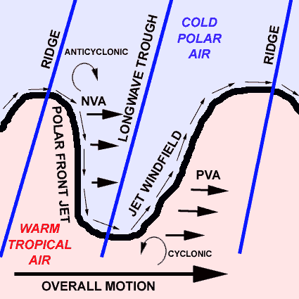 |
The
reverse, anticyclonic or negative vorticity
advection (NVA) will occur between the crest of
an upper ridge and the back of the trough, due to
the same process but with a clockwise
(anticyclonic) spinning motion induced into the
air as it runs up around the ridge. In such areas
air is descending instead of ascending. Descent
is very adept at killing off convection. Thus as
the upper trough passes, severe weather becomes
increasingly unlikely to occur. The timing of
upper troughs and ridges is thus of considerable
importance in severe weather forecasting. All
other parameters may be in place for a big summer
thunderstorm, but then along comes an upper ridge
at the best time of day for storm formation and
the whole thing fizzles out! |
Vorticity is affected by other factors too. Shear is
important. It's caused by winds of different speeds
running side-by-side. Air in an environment with stronger
winds to the south and weaker ones to the north will be
given enhanced cyclonic spin. Since windspeeds for
different pressure levels are available via sites such as
Wetterzentrale, this can be factored into
a forecast.
Shear in which windspeed increases occur with height
(speed-shear) may also be estimated from the charts. Some
speed-shear is pretty much normal as you will notice when
climbing a mountain. A breeze at the bottom can be a
near-gale at summit-level. There's less surface friction
up there which is one factor. But in the upper
troposphere the proximity of the jet can bump the
windspeed up massively. Speed-shear is important in
convective situations as it literally whisks away the
"exhaust" of a storm, thus helping to prolong
it. It's a bit like an open fire drawing well. Strong
speed-shear occurs when the jet is racing overhead. In
this environment, cumulonimbus anvils may stretch for
many miles downstream due to the icy cirrus of the anvil
being dragged downwind. When there's hardly any
speed-shear the storm-tops have a much more symmetrical
shape to them.
Directional shear in the upper atmosphere basically means
that up there the winds are blowing in a different
direction to what they are at the surface. This can be of
importance in severe storm development, including the
formation of tornadic supercells.
DIFFLUENCE AND CONFLUENCE
Both troughs and ridges can be either diffluent or
confluent. These terms deal with the way the air flows
into, and out of, these features. Diffluence (or
divergence) involves the air moving rapidly into a ridge
or trough but slowing down upon leaving it. In the case
of troughs, diffluence permits the conditions ripe for
intense cyclonogenesis. Confluent troughs are those in
which the air leaving the trough area is faster-moving
than that entering it, and these tend to have stable,
anticyclonic weather in their wake. These features can be
picked up using upper-air windspeed charts.
JET STREAKS, THEIR ENTRANCES AND EXITS
Within the overall circumglobal wind-field of the
jetstream, there occur local bands with much stronger
winds than elsewhere. These are called jet streaks (and
sometimes one may be referred to as a jet max). They form
in response to localised but major temperature-gradients,
and consist of narrow zones in which the
pressure-gradient is especially steep as a consequence,
shown on pressure charts by the isobars being very close
together. They move along the lobes, following the
troughs and ridges, and affect these in their passing,
strengthening them as they move in and weakening them as
they move out. They also influence the weather below even
if moving in a fairly straight line when there are few
longwave ridges/troughs about.

Fast jet streaks with winds as high as 200 knots pull in
air upstream (to their west) at what is called an
Entrance Region and throw it out downstream (to their
east) at what is called an Exit Region. These are further
subdivided, as in the diagram above, into Left (to the
north) and Right (to the south). A mass of air heading
into a jet streak's Entrance region is accelerated by the
force of the pressure-gradient operating to its left.
During this process there exists an imbalance of the two
forces controlling the situation - the pressure-gradient
force to the north and the Coriolis force to the south.
The pressure-gradient force is the more powerful of the
two in this area. It forces the air to be pulled to the
left (northwards), a bit like you might expect a car to
constantly veer left if the front passenger-side tyre's a
bit flat and all other tyres are at the correct pressure.
In the Exit region, the air is leaving the jetstreak and
entering an area with a more relaxed pressure-gradient.
It slows down, but in the opposite scenario to the
process going on in the Entrance region it is in this
case made to veer to the right (southwards) because the
Coriolis force is the stronger one here.
With such narrow zones of high winds, considerable shear
occurs resulting in induced vorticity of both positive
and negative types. These are distributed differently on
the north and south sides due to the following reason:
within a jet streak an air parcel will flow parallel to
the isobars but in its entrance and exit regions it
instead flows across them - due to the deflection process
explained above. This can cause either convergence or
divergence. This is shown in the diagram below, in which
the red arrows show the prevailing airflow direction, the
black lines are the tightening isobars within the jet
streak and the blue arrows show the manner in which the
air entering or leaving a jet streak is deflected due to
the pressure gradient force (Entrance region) or the
Coriolis Force (Exit region).

Convergence involves winds from different directions
coming together in a given area. Divergence involves
winds from a given area spreading out from that point
because they are blowing in different directions. In the
western, Entrance region of a jet streak, this results in
convergence within its northern (left) part and
divergence within its southern (right) part.
Positive vorticity (as described above) is associated
with divergence, so not surprisingly the Right Entrance
region is a likely area for PVA to be present,
encouraging convection and cyclonic development below.
With the Exit region the opposite is the case, in that
the Left Exit region is where any PVA will be found and
the Right Exit region is one of NVA, implying descent and
uneventful conditions. Jet streak Left Exits are
essentially at the leading edge of a jet streak, so they
arrive on the scene first, causing surface weather-fronts
to become active as they over-run them, or allowing
convective storms to develop vigorously. This occurs
because as the air in the Left Exit diverges (moves
apart), something has to replace it, so new air rises
from below in order to achieve this: in turn, lower-level
air converges (comes together) to replace that and a
deepening low-pressure system, or intense convection,
results.
Let's have another look at that upper-air (300 hPa)
wind-chart. We now know that for cyclonic or convective
weather to be supported, we need to look for the area
ahead of an upper Longwave Trough axis, for smaller
Shortwave Troughs and for Left Exit and Right Entrance
regions of a jet-streak. These are all nicely shown on
this chart. It would suggest unsettled conditions to be
most encouraged in the following areas:
a) southern of Greenland (Left Exit of jet streak/ahead
of Longwave Trough axis)
b) to the SW of Portugal (PVA ahead of Longwave Trough
plus cold air aloft in upper vortex)
c) the S of the UK (PVA ahead of approaching, diffluent
Longwave Trough axis)
d) the S of Italy and the sea to the SE (PVA ahead of
Shortwave Trough)
The weather that day showed this to be not far off the
case. An active low-pressure system was present over the
S of Greenland. High pressure in the mid-Atlantic gave
way to slack low pressure essentially following the upper
trough. Flabby, slack highish pressure sat over most of
continental Europe. An active cold front brought some
squally rain to England and Wales, while thunderstorms
broke out widely in the Atlantic to the W and S of
Portugal and another thundery area developed over S Italy
and Sicily and moved east. All of these events were
supported by what went on aloft, so in conclusion, it's
well worth learning to understand these initially
confounding plots of what's going on way up in the
Troposphere!
New! Fine Art Prints & digital images for sale-
Welsh Weather & Dyfi Valley landscapes Slide-Library - Click HERE