WINTER
2003-2004 PART 3:
THE DYFI VALLEY DELUGE - 3rd/4th Feb 2004
BACK TO WEATHER-BLOG MENU
New! Fine Art Prints & digital
images for sale-
Welsh Weather & Dyfi Valley landscapes Slide-Library
- Click HERE
This
page is dedicated to the extraordinary 5-day rain event
that occurred during the first week of February, and the
flooding that ensued. As for snow, thus far we have
missed out mostly, even during the elsewhere spectacular
thundersnow event on January 28th. Snow was falling for a
while in Machynlleth that afternoon but failed to
accumulate. Moderate falls were, however, recorded inland
in Powys - and a fortnight earlier in the month, the same
picture was the case.....
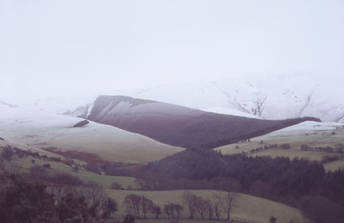 .....as in this pic with a well-defined snowline on the flanks of Moel Fadian, as seen from the Machynlleth-Llanidloes mountain road. A virtual whiteout exists above - that is: when fresh snow covers the ground, the cloudbase is low and it is snowing heavily. Under such circumstances, the ground can seem to merge imperceptibly with the air, creating highly dangerous conditions for mountain walkers trying to navigate their way off the hill... |
|
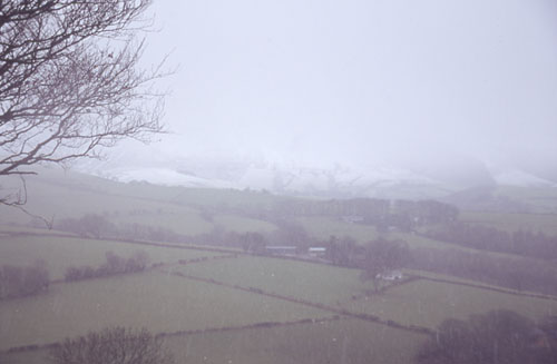 ...and in this one, taken on the same day - January 14th. The sleety snow is badly obscuring the view now and can be seen falling in the foreground. If the air close to the ground is not cold enough, falling snowflakes will begin to melt as they near ground level, and the result is of course sleet - horrible wet globby stuff that always seems to find its way down your collar before it has completely melted! But onto something more significant: |
|
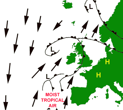 The cold snap at the end of January 2004 gave way to very mild (even warm) south-southwesterly winds with a long, long "fetch" down into tropical areas (see sketch above). Laden with moisture, they set in at the beginning of February and lasted for several days. Low after low formed in this airstream and ran into the UK from the SW. In these conditions rain tends to fall on western hills with dryer areas to the east ("rain-shadows"). Gales or local storm-force winds were one feature of this setup but the rain was the main one. It began raining on Saturday February 1 and didn't really stop until late in the night of Wednesday February 4th, by which time Capel Curig in Snowdonia had recorded over ONE FOOT of rainfall! 261mm of this were recorded on the 3rd and 4th!! The following images track the worst 48 hours from 8pm on the 2nd to 8pm on the 4th, during which heavy rain fell almost relentlessly: |
|
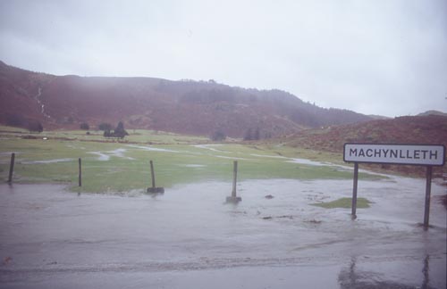
 After a night of steady rain, Tuesday morning showed no letup, as in this pic taken in lashing, pelting rain from squelchy fields on Wylfa, looking NE towards Machynlleth with the Dyfi already well out across the fields... |
|
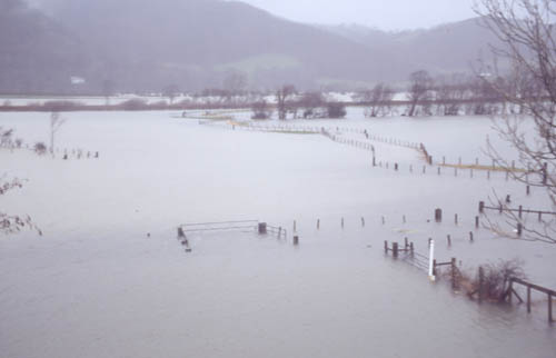 By the afternoon, with the rains continuing, the water was getting deeper... |
|
 ...and it was no surprise to see 5-6 inches of water on the A487 out to Dyfi Bridge - still passable with care but with high tide due at 8pm the situation would now deteriorate as the incoming tide in the estuary only 10km downstream would start to pond the floodwaters.... |
|
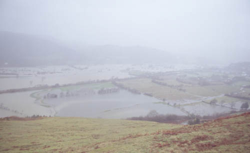
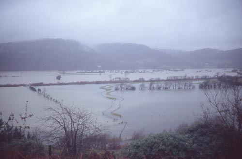 By the following morning (Wednesday 4th) despite a brief pause in the rain overnight, deep water filled the valley from side to side - and down it came again! It was a case of go out, take pix, come home & dry out the camera (and find dry clothes!). |
|
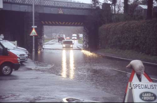 At the Railway Bridge in Machynlleth there is a bit of a dip in the road that has caught a lot of people out over the years. Just passable at high tide on Wednesday morning in transit-type vans and bigger vehicles, but rising again... |
|
 By Wednesday afternoon after several more hours of downpour the water simply ran off the hillsides and across the fields wherever it could. This is Machynlleth golf-course... |
|
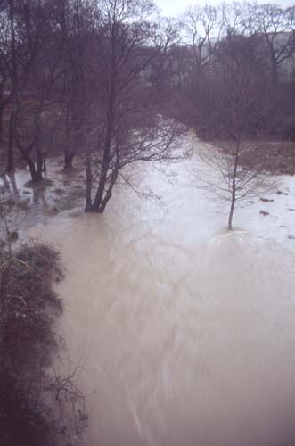 ...and this is the "brook" that passes under the Newtown road at Abergwyddel. All heading for one place only - the main Dyfi valley.... |
|
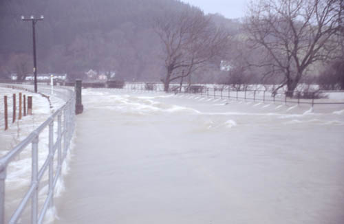
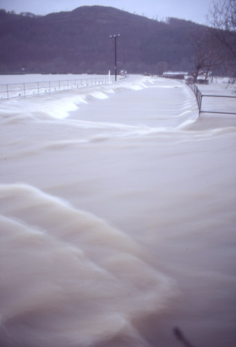 By 4pm on Wednesday following the A487 out to Dyfi Bridge was no longer an option. The water in the centre of the road is over a foot deep with a powerful standing wave on top of that caused by the force of the water pouring through the steel railings on the R. The LHS of the road is raised as there is a separate cycle-track along there. This isn't the river itself. That is another 500m away - the houses in the background are by the bridge! It's not the depth of the water that is the main issue but the strength of the current. A year or so back a cyclist attempted, in similar conditions, to wade this section before the steel railings were put in. He was swept into an old fence and his life was only saved by a major human effort... |
|
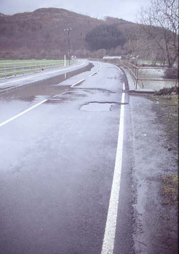 24 hours later at the same spot... The rain stopped on Wednesday night, thankfully. The floods dropped back over the next day (although the railway bridge was still impassable to cars), revealing damage to the tarmac road-surface and lots of debris caught up in fences and hedges... |
|
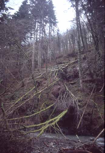 ....and in other areas signs of landslipping. This is in the valley of the Afon Wen near Dolgellau, where an old landslip had reactivated bringing further trees and debris down into the river. 261mm of rain in 48 hours only 40 miles to the N of here; near-record warm temperatures (records were indeed broken in some areas that week) - that's what can happen when the air comes up from the tropics in wintertime. It is perhaps fortunate that such prolonged severe rain events are comparatively unusual in the UK! A flood like this maybe happens one winter in three although less powerful ones are witnessed most winters. |
|
BACK TO WEATHER-BLOG MENU New! Fine Art Prints & digital images for sale- Welsh Weather & Dyfi Valley landscapes Slide-Library - Click HERE |