BACK TO WEATHER-BLOG MENU
New! Fine Art Prints & digital images for sale-
Welsh Weather & Dyfi Valley landscapes Slide-Library - Click HERE
It's February 20th and my first post of 2012. Does this imply that the weather has been uneventful here in Mid-Wales? To an extent, yes: we haven't seen anything like the cold and snow of the past two winters and Machynlleth has had no lying snow at all. Up on the hills things have been a bit different, but putting my back out badly in mid-January messed-up any opportunity to get up there and make the most of it.
In meteorology, winter is defined as December, January and February (often abbreviated to DJF), so we're nearly at its end, although of course wintry weather can occur in October, November, March and April and frost can feasibly occur in any month given the right synoptic patterns. But the notion that spring is a mere nine days away will do me. Indeed, it looks as though some very mild weather is on the cards this coming week to see the winter out.
The year began on a stormy note with the Atlantic jetstream in full bore, bringing in one low after another. On the morning of January 3rd, a surging cold front and accompanying squall-line created a degree of interest: however, for this part of the world it was to arrive before daybreak. Here it is, on the radar at 0730 GMT:
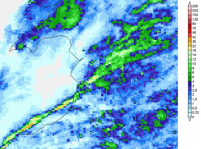
Undeterred by the pre-dawn situation, I lurked in my front doorway, camera and flash primed, for the rising wind that would mark its arrival......

This isn't snow - it's rain! I had to dry off the lens after the second shot. I contemplated whether the neighbours were wondering what the hell I was doing.....

This was quite a vicious low that at 00z on the 3rd was off NW Scotland at 968mb; 24 hours later it was ploughing into southern Norway at 958mb. The storm caused a lot of damage across Scotland in particular. Here, it fell to a very low 953mb over western Scotland and it also produced what is known as a sting-jet. What's one of those when it's at home? To find out, we need to step back nearly 25 years.
A very detailed analysis of the Great Storm of 1987, which was done by a team led by Professor Keith Browning at Reading University and published in 2004, identified a mesoscale flow feature, in which the most damaging winds of the low in question were shown to be coming from the evaporating tip of the hooked cloud-head on its southern flank. The hooked shape reminded the researchers of a scorpion's tail, hence the name they coined for it. What happens is that the evaporation causes the upper air to cool further, making it denser, accelerating it downwards towards the surface through gravity. At the surface, this is marked by extremely severe gusts in excess of 80 knots along a path corresponding to the track of the low and the hook feature. A good example can be seen here: http://www.cas.manchester.ac.uk/resprojects/diamet/satellite/ with the hooked cloud-head clearly visible in the left-hand side of the image. It was a similar feature that wreaked havoc along a path through Central Scotland on the 3rd.
Here, we had a bog-standard force 9-10 storm, of the kind that occurs almost every winter once or more. The odd tree down and general debris littering the roads is pretty much business-as-usual at this time of year. Afterwards, I wandered down to Borth to see if anything interesting had washed-up. Visibility was poor with mist and occasional drizzle the order of the day:

The gulls and oystercatchers were gathered along one short embayed section where the stumps of the ancient "fossil forest" were protruding from the sand. Where the birds are busy there's always something of interest to check out....

They had finished off most of the washed-up clams but I recovered a half-bucket, which were frozen down for bait although I did eat a few of the less pecked ones! They are very fleshy with quite a strong (and possibly acquired) taste. However, one clam cast out into the surf at the right time of year can produce a nice 5lb bass which will feed two very amply, so using them for that purpose is a no-brainer really.

January, though, is not a noted time to fish for bass, and the late-season fishing is generally tailing right off, with just a few dabs and whiting caught on the evening of the 13th. But the sunset more than made up for the lack of decent fish...

I thought I might catch a shot of the elusive 'green flash' as the sun finally sank beneath the horizon....

...not this time!

But as night fell I was rewarded with, firstly, the best starlit night sky I have seen in quite a few months and secondly, at about 2030, a shooting-star that caught my eye: one sees plenty of these when fishing at night but this one suddenly brightened up like a white Roman Candle as it crossed about a third of the sky after my first sighting. More impressively still, it then split into two fragments which traced divergent paths across the sky to my NW before fading out. It was obviously a space-rock as opposed to the specks of dust that are shooting-stars. Enquiries online found that the fireball had been seen by others in the western UK from South Wales to Cumbria - all reporting the splitting apart. That made my night!
A forced interlude then followed as my recurrent lower back problem flared up for the first time in a few years, forcing an expensive visit to an osteopath and a couple of weeks laid-up and a couple more of slowly getting back to normal and taking on physical tasks again. The weather had turned much colder and there were some clear, crisp winter days to enjoy as I plodded about getting the joints loosened-up again....

Although parts of England saw snow and overnight temperatures down as low as -15C, Mid-Wales fared much better: -7C was the worst frost in Machynlleth and milder conditions soon returned. Wondering if I was actually going to see any snow at all in 2011-12, I headed for the hills on the afternoon of the 19th when an unstable NW airflow brought showers that were falling as rain in the valley but as snow above about 300m. Up near Dylife the ground was well covered, even if nothing compared to previous winters....

The showery nature of the snow was illustrated by the following two views from the top of the mountain-road: looking south-east towards Llanidloes:

And south-west towards Plynlimon, with a fraction of the snow further inland, despite the ground being much higher. The snow showers were aligning themselves into streamers, so that whilst some areas saw just the occasional one, others had one after another.

Coming back over to the Dyfi Valley side of the pass, the view at the Wynford Vaughan-Thomas memorial was not up to its usual standard and heavy snow began to fall...

...before slowly clearing from the NW....

Here's a telephoto looking north to Mynydd Cemmaes...

....and south to Moel Fadian, the remnants of the shower drifting away. The sunshine had a wondeful springlike feel to it. Everything will be bursting into life soon....

Recovering from the back has had me back in the garden but the following two photos were taken in January. First, some decent parsnips from a specially-prepared bed:

And secondly, the 'control-batch' - ones grown in unprepared ground.

Preparation, in this stony ground full of sharp slaty fragments, involved whacking a 6ft pointed steel spike 2ft into the ground and then rotating it so as to make a cone-shaped hole. This was then carefully filled with sieved soil and the seed planted bang in the centre. And yes - it worked very well. This area has a reputation for difficulty when it comes to growing decent root-vegetables, yet some careful advance preparation - gleaned by talking to the boys who work the allotments in town over a Guinness or two in my local - paid off.
The creation of 'barrier-zones' between the beds and the margins continues apace: this is to try and keep back the highly invasive creeping buttercup...

...a heap of which was piled ready to burn. Get a hot wood fire going, then carefully build the buttercup around it; leave to burn down, put the remains through a sieve and scatter the ash back on the beds - it contains useful potassium, magnesium, calcium and it also counters the natural soil acidity of the area.

Finally, a sunset shot of the Dyfi taken on the same evening.....

......and, in the strict meteorological sense, that was winter 2011-12! More soon.
BACK TO WEATHER-BLOG MENU
New! Fine Art Prints & digital images for sale-
Welsh Weather & Dyfi Valley landscapes Slide-Library - Click HERE