BACK
TO
WEATHER-BLOG
MENU
New!
Fine
Art
Prints
&
digital
images
for
sale-
Welsh Weather
& Dyfi Valley landscapes Slide-Library - Click HERE
Note: a
version of this post for
people familiar with geology and climate science can be found HERE.
| "The
climate
has
always
been
changing",
or
words
to
that
effect.
How many
times have you read that? It is usually a sign that the person making
the statement has run
out of other arguments with which to attempt to rubbish climate
science.
So: what's the answer? Sure it has! The rocks here in Mid-Wales were formed at a time, over 440 million years ago, when a remarkable period of climate change occurred - and they record its passing. However, I should add an afternote. The change was accompanied by the second biggest mass-extinction in the fossil record of the last 542 million years - from the Cambrian Period until the present day. The rolling hills of the Cambrian Mountains that form the backbone of Mid-Wales are made up of grey rocks that on first appearance are rather boring - slates, shales and sandstones. It's therefore surprising to know that they record such a drastic event. Before we go into how they do, let's have a quick look at the geological timescale, so that we can set the coordinates on our Tardis for a closer look at that time:  I've abbreviated the Period names because there wasn't enough room! The relevant ones here are: ORD = Ordovician Period, 488.3-443.7 and SIL = Silurian Period, 443.7-416 million years ago. We'll go up into the mountains, heading for the hill of Carn Owen that overlooks the Nant-y-moch reservoir. Carn is Welsh for Cairn, and at the top of Carn Owen there is indeed a Bronze-Age ring-cairn, looking out over the vast landscape:  The sides of Carn Owen have been heavily quarried in the past, and two of the smaller quarries reveal something rather interesting. The photo below shows the western one. Straight away, the rocks can be seen to be forming layers, and the layers are all tilted at the same angle to the right (eastwards). These are sedimentary rocks - they are made up of sediment - sand, silt and mud. They were deposited underwater on an ancient seabed, in the late Ordovician Period, about 444 million years ago. 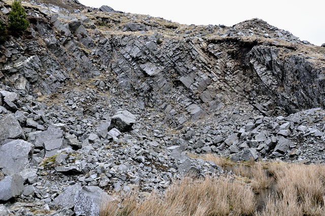 Because one layer of sediment gets deposited on top of another, the higher layers in the photo are younger than the lower layers. And because the rocks are tilted, if in this immediate area you go from left to right (west to east) you will be looking at younger and younger layers of sedimentary rock. The rocks that form the Cambrian Mountains might all look grey from a distance, but when you get close-up to them, they are a bit more interesting! The thick layers in the quarry are sandstone and this is what it looks like in person. Full of small grains of white quartz, it is pale, hard and splintery. In some other places locally, it also contains rounded quartz pebbles. Now, in order to carry coarse-grained sediments such as sand and pebbles to their resting-place, you need strong currents. Geologists have worked out that the sandstones were deposited by what are called Turbidity Currents - mixtures of water, sand and other debris, that poured from the shallower waters of what is now East Wales, down the slopes into the deep-sea basin that occupied Mid-Wales back then.  The next picture shows the second, or eastern quarry face. As I explained above, we have climbed a little higher up through the sequence of rock-strata. In fact this small rock-face marks the boundary between the Ordovician and Silurian Periods, 443.7 million years ago. The boundary is at a change in the rocks - can you see it? 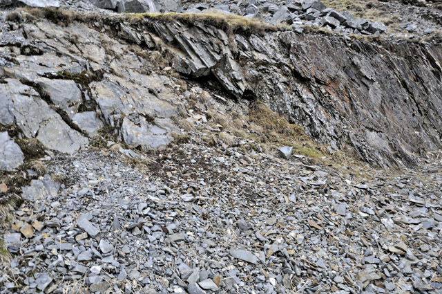 It's right in the middle of the rock-face. To the left are grey rather solid-looking rocks, from the last few thousand years of the Ordovician Period, but near the middle they are overlain by rather flaky, rusty-coloured rocks. The rusty-coloured rocks belong to the lowermost Silurian Period. Here is a close-up of the rocks at the top of the Ordovician - they really are grey and boring!  But here are the rocks from the Lower Silurian - far more to see here, just in terms of colour alone. This rock is very fine-grained - it is a mudstone. Although dark grey where freshly broken, it has weathered in many places to a rusty colour. That is because the mudstone contains a lot of pyrite - iron sulphide - that turns to rusty iron oxides when exposed to air and moisture - just like iron does in time. The technical name for this rock is "hemipelagite" - translated this means "deep sea mud".  The Lower Silurian rocks also contain a lot of fossils, which makes them even more interesting compared to the Ordovician sandstones. The commonest fossils are graptolites (below). This specimen, with individuals 4-5cm in length, shows how they can be beautifully preserved by pyrite that has perfectly replaced their remains. So what were graptolites? They were free-floating organisms that existed, like modern jellyfish or plankton, close to the sea surface, drifting freely with the currents of the seas. 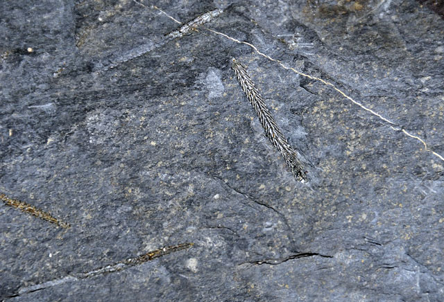 Pyrite is everywhere in these Lower Silurian mudstones, as this photo taken down a special microscope shows. Here, the pyrite shows up as bright areas, the biggest of which is only a millimetre across. For pyrite to be this abundant, the chemical environment on the sea-bed must have been one where free oxygen was scarce or absent, like the bottom of a stagnant pond, full of stinking, sulphurous black mud.  So, in a sequence of rocks across just a short distance on this mid-Wales hillside, we have seen a change over less than two million years from high-energy, turbulent conditions, when sands and pebbles were deposited, to a stagnant, deoxygenated undersea plain where fine, muddy sediment only accumulated slowly and fossil remains were preserved in pyrite. What happened? THE GEOGRAPHY OF THE LATE ORDOVICIAN, 444 MILLION YEARS AGO Reconstructions of the planet's geography over the past few hundreds of millions of years show how, due to movements of the Earth's tectonic plates, the continents have drifted around, collided and split up through time. The globe below is such a reconstruction: is shows how things would have looked at the end of the Ordovician Period, when the rocks of Carn Owen were being deposited. England, Wales and southern Ireland were part of a block of continental crust known to geologists as Avalonia, which lay at a low latitude in the Southern Hemisphere and the South Pole was straddled by the large continent of Gondwana. 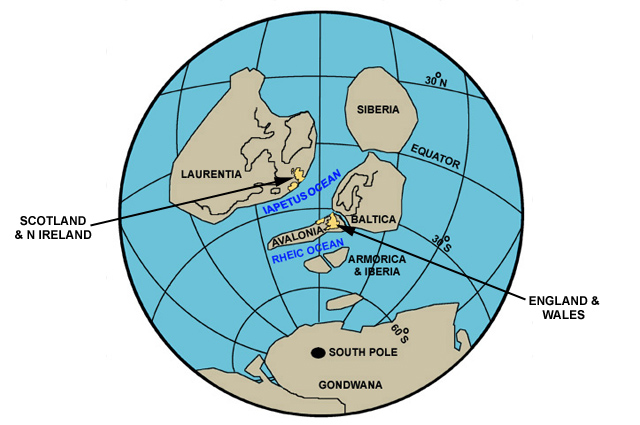 Zooming in, this is what the area that is now England and Wales would have looked like at the time of the deposition of the sandstones of Carn Owen. 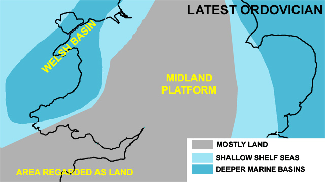 How do we know? By geological mapping - of the types of rocks and their fossils - we can reconstruct what the environment was like at any given time in the past. It gets much harder the further back you go, because the very old rocks of a billion years and more in age generally don't contain fossils and have been so messed-with by heating and pressure. But in the Ordovician and Silurian Periods, we can get a reasonable picture of what it was like. 440 million years ago sounds like a long time, but when the Earth is 4,600 million years old, it doesn't sound like so much! The next map is just a few million years before: 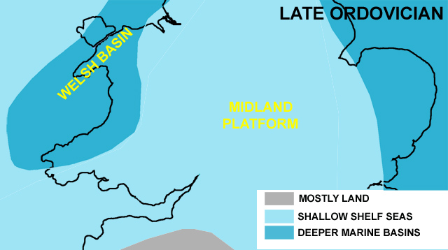 And the next one is the same area in the early Silurian. Look how the land of the Midland Platform was submerged, then it emerged from the sea, then by the early Silurian it was being flooded again. It has been estimated that a sea-level fall-and-rise of at least 80 metres took place to bring this about. What caused it? 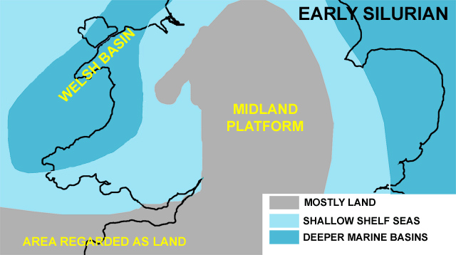 That's a good question. First let's think about the consequences of the sea-level changes. This sudden (in geological terms a couple of million years is sudden) retreat and readvance of the sea had profound effects. For a start, the retreat caused extensive areas of shallow sea, teeming with life, to become dry land. That was one factor in the great mass-extinction that accompanied the changes - loss of habitat. The land at the time was not vegetated like that of today: the first primitive land-plants only appeared during the Ordovician and it was only later in the Silurian that they really became widespread. As a consequence, with nothing much holding the ground together, loose sediment was readily eroded from the newly-emerged land by rainfall and rivers, swept along to the edge of the deeper water and trundled down into its depths by powerful submarine currents, covering the basin floor with mud, silt, sand and, in places, pebbles. Thus were the sandstones of Carn Owen deposited. When sea-levels rose again in the early Silurian, flooding back over the land, the erosion of sediments by rainfall and rivers stopped and the deepwater area became isolated from the sediment source, so that only the finest muds settled out over its depths, onto which the remains of the graptolites and other creatures settled out from the near-surface waters high above. In this way, the pyrite-rich fossil-bearing mudstones came into being. So what caused this sudden double-flip in sea-levels? We have to look at the rocks that were deposited over the great southern continent, Gondwana. GLACIERS IN THE SAHARA? THE REMNANTS OF GONDWANA Gondwana, the huge continent that straddled the South Pole in the late Ordovician, has long since split up into fragments that have drifted away in all directions. Bits of it now make up Africa, South America, India, Antarctica and Australia. In several of these modern continents, late Ordovician rocks occur that have features that can only have had one origin - from glaciers and ice-caps. Such "direct indicators" of ancient glaciers that are preserved in the geological record include things like striated (scratched) rock surfaces - ice-sheets full of rocky debris, like giant sheets of sandpaper, do a good job of grinding down the rocks underneath. The striking image below shows an example: it illustrates an Ordovician glacially-striated rock surface in the Libyan part of the Sahara Desert! 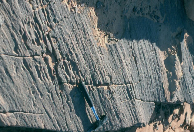 There are also "indirect indicators" of ancient glaciation: the fall (and subsequent rise) in sea-levels, recorded on Carn Owen by those changes in rock-types described above, is to be found in marine rocks of the same age all over the world - therefore the sea-level changes were "eustatic" - global - in nature. In other words, there was a global cooling, leading to a major ice-age, with global sea-level falls due to so much water being locked up in ice, followed by a global warming, melting the ice and bringing worldwide sea-levels back up again. How, then, did it happen? THE DRIVERS OF CLIMATE: TECTONICS, ATMOSPHERE AND SUN There are several major drivers of global climate that, working together, could have made this happen. The geographical arrangement of the continents due to plate tectonics affects the flow of air in the atmosphere and the currents of water in the oceans, moving warm and cold air and water about. The composition of the atmosphere, in terms of greenhouse gases like carbon dioxide, affects its ability to lose heat to outer space or retain it. The energy output from the sun affects the amount of energy reaching Earth. Taking geography first, having the continent of Gondwana over the South Pole would be advantageous if you want ice-caps to start forming: it would have played a role similar to that of Antarctica today. The poles are always the coldest parts of the planet and are even colder if they have continents stuck over them. So that's one box ticked. As to atmospheric composition, carbon dioxide levels during the Ordovician were much higher than today, running at several thousand parts per million (ppm). Through much of the Ordovician, Earth had a stable but very warm climate compared to today. It seems that a fairly stable carbon-cycle existed, with a balance between carbon sources such as volcanoes and carbon sinks such as oceans. However, in the late Ordovician, the stability seems to have been disturbed. It is thought that this was because volcanic activity died away, so there was less carbon dioxide being added to the atmosphere. At the same time, continental collisions led to new mountain ranges being formed in places such as what is now eastern North America, with erosion and weathering of rocks. Rock-weathering is a tremendous carbon dioxide sink: the gas dissolves in water, which then falls as rain: rainwater carrying dissolved carbon dioxide is weakly acidic and reacts with certain common minerals that make up many rocks. The result is solutions carrying carbonate in solution plus metals such as calcium and magnesium: in seawater, these drop out of solution to form limestones. So the carbon dioxide gets locked away in large amounts. There is a lot of evidence for exactly this scenario to have happened in the late Ordovician, in extensive areas where sediments from such new mountain ranges would have been deposited, the resultant carbon sink causing carbon dioxide levels to drop from about 5000ppm down to 3000ppm or less. 3000ppm of carbon dioxide still sounds high but we haven't looked at all the major drivers of climate yet: we still have one more to think about. What about the Sun? The Sun is a main sequence star - it behaves in a reasonably predictable way over thousands of millions of years. Solar energy output is thought to have increased steadily by about 10 per cent per billion years of Earth's history and it is estimated that, in the late Ordovician, it would have been 4-5 per cent dimmer than it is today.  What difference would that shortfall in solar energy make? Global climate models tell us that, at the moment, polar ice can persist when carbon dioxide levels drop below 500 ppm (of course, they are below that at the moment and have been for 25 million years or so). The same models, adjusted for factors like the the dimmer sun of the late Ordovician, predict that for glaciers to have formed at the poles back then, carbon dioxide levels would need to be below 2240-3920 ppm. So: combine a dimmer sun, a sudden drop in carbon dioxide levels and a large continent over the South Pole and that appears to have been enough to get the temperature down and allow glaciers to develop, due to several major climate drivers working together. RAPID ENVIRONMENTAL CHANGE AND MASS-EXTINCTION According to the fossil record, during this late Ordovician ice-age, 26 per cent of all families and 60 percent of all genera of life worldwide died out. It was the second-biggest such mass-extinction event in the fossil record - there being five really big ones, including the K-T event that killed off the dinosaurs and the end-Permian or P-T event that was the biggest of the lot, when life on Earth was almost totally wiped out. The diagram below shows how the Late Ordovician event sits with the others.  We know that the late Ordovician mass-extinction accompanied a period of rapid climate change - a significant cooling that lasted less than 2 million years before a return to very warm conditions. That caused major fluctuations in sea level and changes to ocean temperatures and chemistry. Oceanic changes are blamed for the loss of coral-reefs: although a few corals survived, living reefs themselves disappeared from the face of the Earth and it took as much as 6 million years for them to reappear, making the event the first true ‘reef gap’ in the geological record. There is an important lesson to be learned in this story. That is that any major and geologically rapid climate shift in either direction - warmer or cooler - from a stable state brings with it drastic environmental changes that can have severe effects on ecosystems and create the danger of extinction events. These may occur due to actual habitat-loss, such as the draining of the Ordovician shelf-seas, or due to changes in, for example, oceanic chemistry that are too rapid for evolution to adapt to. That's an important point: life can thrive in both very warm ("Hothouse") and very cold ("Icehouse") climates. It is when the rate of transition from one to another is geologically too rapid for adaptation that the big problems occur. Our burning of the fossil fuels on such a massive scale over just a couple of centuries risks bringing about such changes unless we change the way we obtain and consume energy, by moving more and more to renewable energy sources and in increasing the efficiency and reducing the wastage that is currently present in our energy-use. The "end-game" in terms of Earth's temperature is less relevant: it is the speed at which we get there that really matters. Several degrees in a couple of centuries: this is a serious possibility if we carry on as usual. In geological terms this is lightning-like in its speed. It leaves the Ordovician changes stuck behind, still in the starting-blocks - and remember what happened back then. Nobody wants to bring about the sixth mass-extinction, but unless we find a way through this minefield, that scenario will not go away quietly. It's surprising what the geology of a couple of small, grey crags on a Mid-Wales hillside can tell us! |
|
BACK TO WEATHER-BLOG MENU New! Fine Art Prints & digital images for sale- Welsh Weather & Dyfi Valley landscapes Slide-Library - Click HERE |