|
The images have
been arranged in a practical manner
into six categories (on six
gallery-pages of thumbnail images).
Click on any thumbnail of interest and
you are taken to a big 800 pixel-width
enlargement for a more detailed look.
The six galleries
are as follows:
Geography
*
The Cardigan Bay Coast from Aberystwyth
to Barmouth (including the estuaries) -
anything tidal in other words.
* The Valleys and their scenery, flora
and wildlife.
* The Mountains: Cadair Idris, the
Tarennau, the Arans and the Plynlimon
massif.
Sorted by
weather-types:
* Storms:
stormclouds, floods and damage. This
is where the thunderstorms lurk!
* Winter: snow, ice, fog and
frost - including extensive coverage
of the recent severe winters.
* Light: rainbows, sundogs,
sunsets, noctilucent clouds:
Nature's psychedelia in other words.
All images on this
website are of course low-resolution
JPEGS. Master images from the camera
(or in some cases older, scanned
transparencies) are archived in TIFF
format at a resolution of 300 pixels
per inch.
If you find an
image that you want to purchase, for
any commercial use (supplied in
digital format) or to put on your wall
as a Fine Art print, every enlargement
page has an email link which is set up
so that when you send the email, the
filename comes straight through in the
Subject line. Images will enlarge to
24 x 16 and in some cases 36 x 24
inches but smaller prints can be
ordered - not everyone has that much
spare wall-space! Prints can be
produced on Giclee Fine Art papers or
as stretched canvases.
|
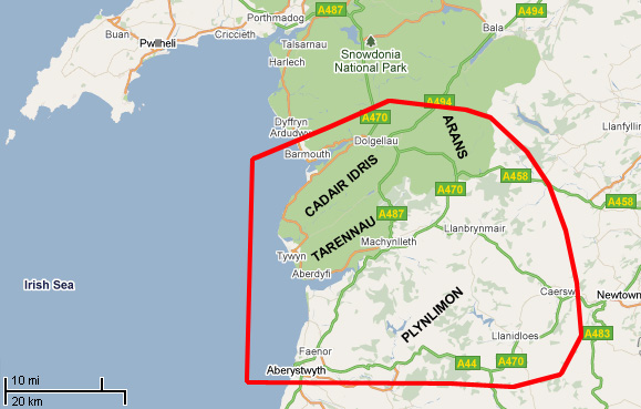 Above
Machynlleth, low wooded hills,
dissected by the numerous
tributories of the Dyfi, give way to
higher hill-pastures and moorlands
rising towards the mountains that
define the watershed of Wales. These
rise to 907m above sea-level at
their highest point, Aran Fawddwy.
Cadair Idris at 893m comes a close
second. These high rocky areas with
their Arctic flora contrast with the
more rolling landscape of the
Tarennau and the Plynlimon massif,
which lie to the south.
Above
Machynlleth, low wooded hills,
dissected by the numerous
tributories of the Dyfi, give way to
higher hill-pastures and moorlands
rising towards the mountains that
define the watershed of Wales. These
rise to 907m above sea-level at
their highest point, Aran Fawddwy.
Cadair Idris at 893m comes a close
second. These high rocky areas with
their Arctic flora contrast with the
more rolling landscape of the
Tarennau and the Plynlimon massif,
which lie to the south.