SEVERE WEATHER PHOTOGRAPHY
FROM MID-WALES:
WELCOME TO JOHN MASON'S WEBSITE
WELCOME TO JOHN MASON'S WEBSITE
A website dedicated to all aspects of Welsh weather but especially to storm-chasing - the art of deliberately intercepting thunderstorms, floods, tornadoes, hail, blizzards and the like, armed with a camera and a certain amount of caution!
Blog Last updated:
12:09:2023
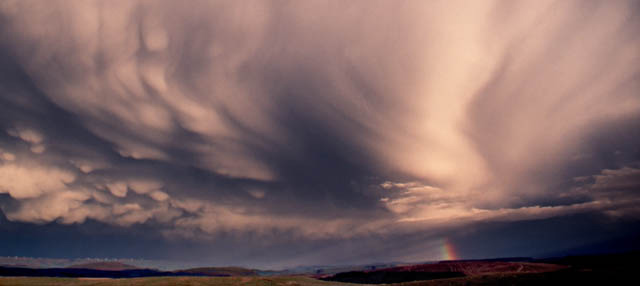 |
above: incredible sheared
thunderstorm anvil with mammatus - near Machynlleth,
May 2003.
SITE-NAVIGATION:
PART 1) IMAGES FOR SALE: THE MID-WALES IMAGE-LIBRARY: CLICK HERE
The Image-Library is a collection of several hundred weather, wildlife and landscape photographs from Mid-Wales. They are arranged by subject in a series of galleries for easy searching. All images are available as prints on archival-quality photo-papers/canvases. They are also available in digital format (hi-res TIFFS or JPEGS) for digital media purposes.
PART 2) JOHN'S WELSH WEATHER PHOTO-DIARY:
The diary pages, indexed below, are the product of my passion for Wales, its landscapes and its weather. They also follow the steep learning-curve I have been upon since the year 2000, in pursuit of the complex sciences of meteorology, forecasting and more recently climatology.
Wales has a "tabloid" reputation for just being wet all of the time. To put it politely this is totally untrue! We have an amazingly varied climate here, from the tranquil beauty of a seascape summer sunset to the full fury of an autumn "Atlantic Bomb" cyclone. The combination of the beautiful landscapes and dramatic things going on in the skies overhead is enough to challenge any serious photographer.
The diary currently contains 223 pages of wild and not-so-wild weatherpix, stormchase accounts and weather/climate-related information - so, while the rain hammers against your window on a winter's night, scroll down and enjoy Mid-Wales, its seasons and its weather!
John, Machynlleth, Mid Wales.
Email enquiries: Click HERE.
| BLOG INDEX: | LATEST WEATHER IMAGES &
BLOGGERY |
WEATHER-BLOG
ARCHIVE BY YEAR |
| CLIMATE CHANGE, ENERGY & METEOROLOGY ARTICLES | ||
 |
above: stunning
Noctilucent Cloud display over Aran Fawddwy,
0230BST, July 3rd 2011
WEATHERPIX - LATEST POSTS:
NEW! SHORE FISHING - A GUIDE TO CARDIGAN BAY: A MAJOR PROJECT COMPLETED
NEW! SPRING 2016: AERIAL WEATHER - SPECTACULAR THUNDERHEADS FROM ABOVE
NEW! NOVEMBER 17th 2016: SERIOUSLY DAMAGING THUNDERSTORM WINDS IN MID-WALES, BUT TORNADOES?
NEW! 2017: ICE CRYSTALS, LUNAR PHOTOGRAPHY, THUNDERSTORM SUNRISE: THE YEAR SO FAR
NEW! 2017 PART 2: THE RE-FINDING OF THE ELUSIVE "MAGNIFICENT URALITE PORPHYRY", IN COED Y BRENIN, NORTH WALES
NEW! 2017 PART 3: ANOTHER PERSPECTIVE ON THE DYFI VALLEY
NEW! 2018 PART 1: JANUARY-AUGUST ROUND-UP (INCLUDES BEAST FROM THE EAST AND THE DROUGHT)
NEW! 2018 PART 2 AND 2019 PART 1: MOSTLY UNEVENTFUL BUT WITH A FEW NOTABLE EXCEPTIONS!
NEW! 2019 PART 2: NEW BOOK - THE MAKING OF YNYSLAS - AND A LIKELY SUPERCELL OVER PENMAENDYFI
NEW! 2020 SO FAR: HUGE TIDE IN MARCH, FULL MOONSET IN APRIL AND LOCKDOWN STORM-CHASING IN JUNE
NEW! 2020 SO FAR PART 2: MORE LOCKDOWN STORM-CHASING - THE PHENOMENAL MID-AUGUST THUNDERSTORMS
NEW! 2021-22: NEW BOOK OUT: WALES - THE MISSING YEARS
NEW! STRONG (T3) TORNADO NEAR PENNAL, GWYNEDD, APRIL 6th 2022: THE FULL REPORT
NEW! A LONG-AWAITED UPDATE -- SEPTEMBER 2023 WITH THE SPECTACULAR LIGHTNING STORM OF 10-09-23
| WEATHERPIX
-
ARCHIVE: |
||||||||||||
| 2013 |
2012 | 2011 | 2010 | 2009 | 2008 | 2007 | 2006 | 2005 | 2004 | 2003 | 1980s-2002 | |
| 2014 |
2015 |
2016 |
2017 |
2018 |
2019 | 2020 |
||||||
|
|

CLIMATE CHANGE, ENERGY & METEOROLOGY ARTICLES:
1) WHY CHASE STORMS? A PERSONAL PERSPECTIVE
2) STORM-CHASING IN WALES - SYNOPTIC OVERVIEW & ADVICE
3) WHAT GOES ON ALOFT - A ROUGH GUIDE TO THE UPPER AIR!
4) HOW HURRICANES CAN AFFECT OUR WEATHER OVER HERE
5) WEATHER EVENTS ARCHIVE: THE AUGUST 9 1843 HAILSTORM - THE WORST ON RECORD?
6) WEATHER EVENTS ARCHIVE: THE TYWYN TORNADO, W WALES, JAN 21, 1995
7) WEATHER EVENTS ARCHIVE: THE DEVASTATING SOUTH WALES TORNADO OF OCTOBER 1913
8) CLIMATE CHANGE AND WALES: A GEOLOGIST'S PERSPECTIVE
*** THE FOLLOWING PIECES START WITH A 2007 POST (no. 9) AND RUN ON TOWARDS NOW ***
9) THE CLIMATE DEBATE- WHERE SCIENCE AND POLITICS DON'T MIX!
10) WEATHER AND THE MEDIA - A RANT
11) TRANSITION TO SPRING? - ENERGY-SECURITY AND VEG-GROWING!
12) THE AGE OF STUPID - PREMIERE 15th MARCH 2009
13) BOOK REVIEW: CLIMATE COVER-UP - PUBLISHED AUTUMN 2009
14) COPENHAGEN COP 15 - NO SURPRISES!
15) CLIMATE WARS & SNOWMAGEDDON!
16) IS GRAVITY LEFT-WING?
17) IN WHOSE BACK YARD?
18) CLIMATE CHANGE OR CLIMATE DESTABILISATION?
19) ON HOTHOUSES AND CHANGING SEAS....
20) DIARY OF AN ECO-NAZI
21) ARCTIC CIRCULATION CHANGE LINK TO DECEMBER 2010 FREEZE? A LOOK AT RECENT RESEARCH
22) ON OLD METAL-MINES, MINERALS AND THE TROPICAL CLIMATE OF 50 MILLION YEARS AGO
23) MID-WALES HILLSIDE RECORDS DRASTIC 444 MILLION YEAR OLD CLIMATE CHANGE!
24) AMINOPYRALID-CONTAMINATED MANURE: A PROBLEM THAT HAS NOT GONE AWAY
25) DIARY OF AN ECO-NAZI PART 2 - THE HANDS-ON APPROACH! (DECEMBER 2011)
26) THE MID-WALES FLOODS OF JUNE 2012: A TASTE OF THINGS TO COME?
27) THE GREAT DISCONNECT: THE HUMAN DISEASE OF WHICH CLIMATE CHANGE IS BUT ONE SYMPTOM
 |
above: Chough and
(unusually for this blog) clear blue sky - Bardsey
Sound, July 2011
WEATHERPIX - 2023
A LONG-AWAITED UPDATE -
SEPTEMBER 2023 WITH THE SPECTACULAR LIGHTNING STORM OF 10-09-23
WEATHERPIX - 2022
2021-22: NEW BOOK OUT: WALES - THE MISSING YEARS
2022 part 2: STRONG (T3) TORNADO NEAR PENNAL, GWYNEDD, APRIL 6th 2022: THE FULL REPORT
WEATHERPIX - 2020
2020 SO FAR: HUGE TIDE IN MARCH, FULL MOONSET IN APRIL AND LOCKDOWN STORM-CHASING IN JUNE
2020 SO FAR PART 2: MORE LOCKDOWN STORM-CHASING - THE PHENOMENAL MID-AUGUST THUNDERSTORMS
WEATHERPIX - 2019
2018 PART 2 AND 2019 PART 1: MOSTLY UNEVENTFUL BUT WITH A FEW NOTABLE EXCEPTIONS!
2019 PART 2: NEW BOOK - THE MAKING OF YNYSLAS - AND A LIKELY SUPERCELL OVER PENMAENDYFI
WEATHERPIX - 2018
1) JANUARY-AUGUST ROUND-UP (INCLUDES BEAST FROM THE EAST AND THE DROUGHT)
WEATHERPIX - 2017
1) ICE CRYSTALS, LUNAR PHOTOGRAPHY, THUNDERSTORM SUNRISE: THE YEAR SO FAR
2) THE RE-FINDING OF THE ELUSIVE "MAGNIFICENT URALITE PORPHYRY", IN COED Y BRENIN, NORTH WALES
3) ANOTHER PERSPECTIVE ON THE DYFI VALLEY
WEATHERPIX - 2016:
1) SPRING 2016: AERIAL WEATHER - SPECTACULAR THUNDERHEADS FROM ABOVE
2) SPRING 2016: SOUTHERN SPAIN PART 1 - RENAISSANCE OF LIFE AFTER THE 2014 COMPETA WILDFIRE
3) SPRING 2016: SOUTHERN SPAIN PART 2 - WANDERINGS IN THE SIERRAS TEJEDA AND ALMIJARA
4) SPRING-SUMMER 2016: THE UNSETTLED PATTERN CONTINUES
5) NOVEMBER 17th 2016: SERIOUSLY DAMAGING THUNDERSTORM WINDS IN MID-WALES, BUT TORNADOES?
WEATHERPIX - 2014:WEATHERPIX - 2023
A LONG-AWAITED UPDATE -
SEPTEMBER 2023 WITH THE SPECTACULAR LIGHTNING STORM OF 10-09-23
WEATHERPIX - 2022
2021-22: NEW BOOK OUT: WALES - THE MISSING YEARS
2022 part 2: STRONG (T3) TORNADO NEAR PENNAL, GWYNEDD, APRIL 6th 2022: THE FULL REPORT
WEATHERPIX - 2020
2020 SO FAR: HUGE TIDE IN MARCH, FULL MOONSET IN APRIL AND LOCKDOWN STORM-CHASING IN JUNE
2020 SO FAR PART 2: MORE LOCKDOWN STORM-CHASING - THE PHENOMENAL MID-AUGUST THUNDERSTORMS
WEATHERPIX - 2019
2018 PART 2 AND 2019 PART 1: MOSTLY UNEVENTFUL BUT WITH A FEW NOTABLE EXCEPTIONS!
2019 PART 2: NEW BOOK - THE MAKING OF YNYSLAS - AND A LIKELY SUPERCELL OVER PENMAENDYFI
WEATHERPIX - 2018
1) JANUARY-AUGUST ROUND-UP (INCLUDES BEAST FROM THE EAST AND THE DROUGHT)
WEATHERPIX - 2017
1) ICE CRYSTALS, LUNAR PHOTOGRAPHY, THUNDERSTORM SUNRISE: THE YEAR SO FAR
2) THE RE-FINDING OF THE ELUSIVE "MAGNIFICENT URALITE PORPHYRY", IN COED Y BRENIN, NORTH WALES
3) ANOTHER PERSPECTIVE ON THE DYFI VALLEY
WEATHERPIX - 2016:
1) SPRING 2016: AERIAL WEATHER - SPECTACULAR THUNDERHEADS FROM ABOVE
2) SPRING 2016: SOUTHERN SPAIN PART 1 - RENAISSANCE OF LIFE AFTER THE 2014 COMPETA WILDFIRE
3) SPRING 2016: SOUTHERN SPAIN PART 2 - WANDERINGS IN THE SIERRAS TEJEDA AND ALMIJARA
4) SPRING-SUMMER 2016: THE UNSETTLED PATTERN CONTINUES
5) NOVEMBER 17th 2016: SERIOUSLY DAMAGING THUNDERSTORM WINDS IN MID-WALES, BUT TORNADOES?
1)
WINTER 2014-15: NOT
1962-63!
2) SPRING 2015: PHENOMENAL!
3) SUMMER 2015 - IT HAD ITS MOMENTS...
4) AUTUMN 2015 - INDIAN SUMMER GIVES WAY TO GENERAL YUCKINESS...
2) SPRING 2015: PHENOMENAL!
3) SUMMER 2015 - IT HAD ITS MOMENTS...
4) AUTUMN 2015 - INDIAN SUMMER GIVES WAY TO GENERAL YUCKINESS...
1) WINTER 2013-14 PART 1: ABERGEDDON - WHY THE STORMS OF JANUARY 3RD-6TH WERE SO DAMAGING
2) WINTER 2013-14 PART 2: JANUARY-FEBRUARY STORMS - THE AFTERMATH....
3) WINTER 2013-14 PART 3: JANUARY-FEBRUARY STORMS - REVELATIONS....
4) SPRING 2014 PART 1: THE BEST SIDE OF PLYNLIMON
5) SPRING 2014 PART 2: EXODUS
6) SUMMER 2014: THE CURSE OF THE DAILY EXPRESS - EX-BERTHA!
7) AUTUMN 2014: TEXTURES IN THE AIR....
WEATHERPIX - 2013:
1) WINTER 2012-13 PART 1: FROM WET TO WHITE!
2) WINTER 2012-13 PART 2: A CELEBRATION OF GIANT WAVES!
3) SHORE FISHING - A GUIDE TO CARDIGAN BAY: A MAJOR PROJECT COMPLETED
4) SPRING 2013 PART 1: CHASING ANCIENT MICROCONTINENTS IN NORTH WALES - THE MEGUMIA PROJECT
5) SPRING 2013 PART 2: WHITE DEATH STALKS THE FIELDS - THE MARCH 2013 BLIZZARDS
6) SPRING 2013 PART 3: THE STUNNING CAMBRIAN ROCKS OF THE FRIOG COAST OF SOUTH-WEST GWYNEDD
7) SPRING 2013 PART 4: THE GREAT MID-WALES BLIZZARD - THE AFTERMATH
8) SPRING 2013 PART 5: FROM BETHESDA TO BARMOUTH - THE PREHISTORY OF SNOWDONIA
9) SUMMER 2013 PART 1: THROUGH THE WILDWOOD...
10) SUMMER 2013 PART 2: THE DARWIN WALL COMPLETED
11) SUMMER 2013 PART 3: LONG LENS LANDSCAPES AND OUTFLOW-BOUNDARIES
12) AUTUMN 2013 PART 1: IN MID-WALES, THE HUNTING/GATHERING SEASON IS WELL UNDERWAY...
13) AUTUMN 2013 PART 2: STORMWATCH!
14) NEW! AUTUMN 2013 PART 3: BRILLIANTLY COLOURFUL, VIOLENTLY STORMY!
WEATHERPIX - 2012:
1) WINTER 2011-12 PART 2: STORMY START, COLDER MIDDLE THEN MILD FINISH
2) SPRING 2012 PART 1: 3,000 YEAR OLD FOOTPRINTS FOUND IN THE SUBMERGED FOREST AT BORTH
3) SPRING 2012 PART 2: FROM SUMMER TO WINTER IN ONE WEEK!
4) ARTICLE: ISN'T NATURE WONDERFUL - AH, BUT IS IT ART?
5) SPRING 2012 PART 3: MID-APRIL THUNDERSNOW THEN A LATE MAY HEATWAVE....
6) SUMMER 2012 PART ONE: THE GREAT FLOOD OF JUNE 9th 2012 - OFF THE SCALE!
7) SUMMER 2012 PART TWO: CANCELLED UNTIL FURTHER NOTICE!
8) SUMMER 2012 PART 3: LLŶN MAGIC, AUGUST THUNDERSTORMS AND GENERAL LIVELINESS...
9) SUMMER 2012 PART 4: A SEA OF CLOUD - AMAZING INVERSION OVER THE DYFI VALLEY
10) AUTUMN 2012 PART 1: DARKNESS AND LIGHT
11) AUTUMN INTO WINTER 2012: THE WORST WINTER IN 100 YEARS SO FAR......
 |
above: two of many
funnel clouds and waterspouts that were
photographed on a morning in September 2011
WEATHERPIX - 2011:
1) WINTER 2010-11 PART 3: ASPECTS OF INUNDATION - DYFI FLOODS AND A LOOK AT SARN CYNFELYN
2) WINTER 2010-11 PART 4: MORE FLOODS PLUS A LOOK AT THE BORTH SEA DEFENCES PROJECT
3) SPRING 2011 PART 1: APRIL HEATWAVE ON CADAIR IDRIS
4) SPRING 2011 PART 2: FROM DESSICATION TO DELUGE!
5) SPRING 2011 PART 3: METAL-TOLERANT PLANTS AND THE COED Y BRENIN COPPER DEPOSIT
6) SUMMER 2011 PART 1: BIG NEWS - DYFI OSPREYS HATCH FIRST CHICKS FOR 400 YEARS!
7) SUMMER 2011 PART 2: JUNE THUNDERSTORMS, MACHYNLLETH HAILSTORM AND DIVING GANNETS
8) SUMMER 2011 PART 3: UTTERLY BREATHTAKING NOCTILUCENT CLOUD DISPLAY!
9) SUMMER 2011 PART 4: MORE NOCTILUCENT CLOUDS, CHANTERELLES AND AEROBATIC CHOUGHS
10) SUMMER 2011 PART 5: TWO PARALLEL WORLDS - AUGUST 1-10
11) SUMMER 2011 PART 6: THE STAMPING-GROUND - AFON LERI AND CRAIG-Y-PISTYLL
12) SUMMER 2011 PART 7: LATE AUGUST THUNDERSTORMS/A RARE SUNNY MORNING AT GLASLYN
13) AUTUMN 2011 PART 1: FUNNEL-CLOUD/WATERSPOUT EXTRAGAVANZA OVER CARDIGAN BAY!
14) AUTUMN 2011 PART 2: APPOINTMENT WITH KATIA
15) AUTUMN 2011 PART 3: SUPERB SUNSET STORM AT BORTH PLUS SOME NORTH WALES GEOLOGY
16) AUTUMN 2011 PART 4: PROBABLE SUPERCELL STORM OVER CARDIGAN BAY!
17) WINTER 2011-12 PART 1: SQUALL-LINES HIT MID WALES AMONGST GENERAL STORMINESS
 |
above: the deep sleep of
Winter - Gogarth (on the Dyfi Estuary), December
2010.
WEATHERPIX - 2010:
1) WINTER 2009-10 PART 1: THE BIG FREEZE-UP
2) WINTER 2009-10 PART 2: JANUARY FREEZE-UP - WORST SINCE 1986!
3) WINTER 2009-10 PART 3: JANUARY FREEZE-UP - SNOWDRIFT SPECIAL!
4) WINTER 2009-10 PART 4: THE THAW/TYWYN SEA DEFENCE SCHEME
5) WINTER 2009-10 PART 5: SPRINGLIKE DAY ON TARRENHENDRE
6) WINTER 2009-10 PART 6: GRAIG GOCH LANDSLIDE & TYWYN BOULDER-DROP!
7) SPRING 2010 PART 1: WINTER CLINGS ON: WANDERINGS AROUND GLASLYN AND BUGEILYN
8) SPRING 2010 PART 2: COLD: THE NORTH ATLANTIC YIN-YANG!
9) SUMMER 2010 PART 1: FROM THE NORTH - ORCADIAN VISIONS
10) SUMMER 2010 PART 2: DOUBLE DROUGHT!
11) SUMMER 2010 PART 3: FIRST STORM-CHASE OF THE YEAR: SPECTACULAR WALL-CLOUD!
12) SUMMER 2010 PART 4: THE GIVING LAND
13) SUMMER 2010 PART 5: SUMMER TAKES A VACATION!
14) AUTUMN 2010 PART 1: BLUE MOSS AND THE IRISH SEA GLACIER
15) AUTUMN 2010 PART 2: CALL THE LIFEBOAT! - MONSTER GROUND-SWELL BRINGS TROUBLE
16) AUTUMN 2010 PART 3: GEOLOGICAL INTERLUDE - BRIEF INDIAN SUMMER ON PARYS MOUNTAIN
17) AUTUMN 2010 PART 4: A SEAWEED-SHANTY!
18) AUTUMN 2010 PART 5: MID-WALES 27C COLDER THAN GREENLAND!
19) WINTER 2010-11 PART 1: BIGGEST MACHYNLLETH SNOWFALL SINCE 1982/WHY IS IT SO COLD?
20) WINTER 2010-11 PART 2: CRAZY ICICLES, ICE-FLOES AND A DEEP-SNOW ASCENT OF TARRENHENDRE
 |
above:
clearing
our local Mountain-Road (Machynlleth to
Llanidloes), February 2009.
WEATHERPIX - 2009:
1) WINTER 2008-9 PART 1: THE DYFI ESTUARY FREEZES OVER!
2) WINTER 2008-9 PART 2: THE ATLANTIC STRIKES BACK!
3) WINTER 2008-9 PART 3: MANY FEBRUARY SNOWFALLS!
4) SPRING 2009 PART 1: LAND, SEA AND SKY AWAKES (RAPTOR DOGFIGHT)!
5) COASTAL EROSION SPECIAL: EASTERN ENGLAND - APRIL 2009
6) SPRING 2009 PART 2: THE LIVING LAND (BUT QUIET SKIES) - APRIL INTO MAY
7) SPRING 2009 PART 3: MAMMATUS, COWS, SUN, SEA AND FOG - LATE MAY
8) SUMMER 2009 PART 1: PAINTED LADY INVASION/CAMBRIAN MOUNTAINS TWISTER!
9) SUMMER 2009 PART 2: NOCTILUCENT CLOUDS AND LATE JUNE TRAIN-ECHO
10) SUMMER 2009 PART 3: STUNNING NOCTILUCENT CLOUD DISPLAY AND THE AIM SATELLITE MISSION
11) SUMMER 2009 PART 4: MYSTERIES IN THE MOUNTAINS
12) SUMMER 2009 PART 5: SOME NOTABLE DOWNPOURS AND ANOTHER A470 LANDSLIP!
13) AUTUMN 2009 PART 1: INDIAN SUMMER SUNSETS BEFORE SEASONAL SQUALLS!
14) AUTUMN 2009 PART 2: MID-NOVEMBER MAYHEM: MAJOR ATLANTIC STORMS
15) TEN YEARS OF WEATHER PHOTOGRAPHY: MY TOP TEN EXPERIENCES OF THE 2000s
 |
above:
Thunderstorm gust-front trundles menacingly over
Ynyslas, April 2008
WEATHERPIX - 2008:
1) WINTER 2007-8 PART 3: JANUARY SQUALLS AND LIGHTNING SUPERBOLTS!
2) WINTER 2007-8 PART 4: THE ABERYSTWYTH WATERSPOUT
3) WINTER 2007-8 PART 4: A SIGNIFICANT WINDSTORM TO COME ON MARCH 10th?
4) WINTER 2007-8 PART 6: A SIGNIFICANT WINDSTORM TO COME ON MARCH 10th) - THE OUTCOME!
5) SPRING 2008 PART 1: AMAZING GUST-FRONT MAKES LANDFALL AT YNYSLAS!
6) SPRING 2008 PART 2: PHOTOGENIC FRONTAL CLEARANCE AND MORE MAY THUNDERSTORMS
7) SUMMER 2008 PART 1: CLOUDS ON THE EDGE OF SPACE - NOCTILUCENT CLOUD SPECIAL!
8) SUMMER 2008 PART 2: WILD THUNDERSTORMS AND WILD FOOD!
9) SUMMER 2008 PART 3: AUGUST - DAMAGING FLOODS AND LESS SUNSHINE THAN FEBRUARY!
10) AUTUMN 2008 PART 1: SEPTEMBER: BRIEF INDIAN SUMMER AND EX-TROPICAL STORM LAURA!
11) AUTUMN 2008 PART 2: WINTER ARRIVES EARLY IN MID-WALES!
 |
above:
intense thunderstorms over Cardigan Bay from
Borth, June 2008
WEATHERPIX - 2007:
1) WINTER 2006-7- PART 2: ELAN VALLEY SPATE AND BORTH BEACH GOES AWOL!
2) WINTER 2006-7- PART 3: FEBRUARY 8-11: THE 4-DAY WINTER!
3) SPRING 2007- PART 1: MARCH 18th: CONVECTIVE STORM SPECTACULAR!
4) SPRING 2007 PART 2: A BUSTLE IN THE HEDGEROW!
5) SPRING 2007 PART 3: MAY - SNOWDONIA STORMCHASE!
6) SUMMER (ha ha) 2007 PART 1: BIG JUNE THUNDERSTORMS
7) SUMMER (ha ha) 2007 PART 2: RAINBOWS, A FUNNEL AND LOTS OF WATER....
8) THE DYFI VALLEY/WELSH WEATHER SLIDE LIBRARY: INTRODUCTION
9) SUMMER (ha ha) 2007 PART 3: A TRIP TO THE BWLCH....
10) AUTUMN 2007 PART 1: QUIETEST SPELL SINCE RECORDS BEGAN!
11) AUTUMN 2007 PART 2: INTERLUDES BETWEEN ANTICYCLONIC GLOOM!
12) WINTER 2007-8 PART 1: THE GIANT SEAS OF DECEMBER 1st - PEMBROKESHIRE
13) WINTER 2007-8 PART 2: THE GIANT SEAS OF DECEMBER 2nd - ABERYSTWYTH
 |
above:
Wavecrash, Aberystwyth, January 2008
WEATHERPIX - 2006:
1) WINTER 2006: UNEVENTFUL, BUT FOLLOWED BY A MARCH BLIZZARD!
2) WINTER 2006 PART 2: SNOW AND ICE AND AIR AND FIRE AND WATER!
3) SPRING 2006 PART 1: WEIRD GEOLOGY, LLYN PENINSULA - THWARTED BY SEA-FOG!
4) SPRING 2006 PART 2: FIRST MAY THUNDERSTORMS AND LOTS OF HAZE!
5) SPRING 2006 PART 3: MORE MAY STORMS AND THE MYSTERY OF THE WHALE'S MOUTH!
6) SUMMER 2006 PART 1: MIDSUMMER TWILIGHT/RIPTIDE!
7) SUMMER 2006 PART 2(a): DESTABILISATION ALLEY!
8) SUMMER 2006 PART 2(b): THUNDERCLOUD SOUP!
9) SUMMER 2006 PART 3: THE DROUGHT STARTS TO BITE!
10) SUMMER 2006 PART 4: THE COMING OF THE ANTI-DROUGHT
11) AUTUMN 2006 PART 1: CLOUDBURSTING!
12) AUTUMN 2006 PART 2: DEVASTATING SUPERBOLT HITS ARANS??
13) AUTUMN 2006 PART 3: SEASONAL SQUALLS!
14) AUTUMN 2006 PART 4: CLOUDSPOTTER'S GUIDE REVIEW AND OPTICS IN PEMBROKESHIRE!
15) AUTUMN 2006 PART 5: THE T4/F2 BOW STREET TORNADO, 28th Nov 2006
16) AUTUMN 2006 PART 6: INCREDIBLE PSYCHEDELIC SUNRISE!
17) WINTER 2006-7- PART 1: THE RAGING ATLANTIC BRINGS CHAOS!
 |
above: total
destruction - caravan, fence & swings -
aftermath of the November 2006 Bow Street
Tornado
WEATHERPIX - 2005:
1) WINTER 2004-2005 PART 1: GREY DECEMBER BUT A WHITE CHRISTMAS!
2) WINTER 2004-2005 PART 2: THE ATLANTIC AWAKES - TORNADOES AND LANDSLIDES!
3) WINTER 2004-2005 PART 3: DEEP SNOW AND BLUE SKIES ON THE ARANS
4) SPRING 2005 PART 1: WINTER'S LAST GASP? - SURREAL SNOW SHOWERS!
5) SPRING 2005 PART 2: APRIL SHOWERS & A WELL DEFINED CONVERGENCE ZONE
6) SPRING 2005 PART 3: THUNDERSTORMS (ONE WITH A RAIN-WRAPPED FUNNEL) IN SW WALES!
7) SPRING 2005 PART 4: DRAMATIC LATE MAY THUNDERSTORM
8)SUMMER 2005 PART 1: JUNE GOES OUT WITH A BANG!
9) SUMMER 2005 PART 2: BOSCASTLE REVISITED!
10) SUMMER 2005 PART 3: TORNADO SIGHTED AND PHOTOGRAPHED NEAR CARDIGAN!
11) AUTUMN 2005 PART 1: THE ATLANTIC SWITCHES ON - WITH STORMS, SWELLS AND FLOODS!
12) AUTUMN 2005 PART 2: FIRST SNOW - COAST TO COAST ON THE Cb-CONVEYOR!
 |
above:
ominous but harmless - mammatus clouds overhang
the hills near Aberdyfi, September 13th 2004
WEATHERPIX - 2004:
1) WINTER 2003-4 PART 2: A TRIP TO THE MIDLANDS/BRISTOL CHANNEL "TORNADO"
2) WINTER 2003-4 PART 3: FEBRUARY 3rd/4th: THE DYFI VALLEY DELUGE (FLOODS SPECIAL)
3) WINTER 2003-4 PART 4: FEBRUARY 25th-27th: SNOW TO SEA-LEVEL!
4) MARCH 2004 PART 1: WINTER'S LAST GASP?
5) MARCH 2004 PART 2: FIRST CONVECTION OF SPRING: 21st-23rd
6) APRIL 2004: SUNNY INTERVALS AND FLOWERS!
7) MAY 2004 PART 1: GUST-FRONT ON THE CARDIGAN BAY COAST
8) MAY 2004 PART 2: MAY 10th - 2 FUNNEL-CLOUDS IN ONE DAY!!
9) MAY 2004 PART 3: MAY 11th - SUNBATHING AND STORMWATCHING!
10) SUMMER 2004 PART 1: GENERAL WEATHERPIX
11) SUMMER 2004 PART 2: JULY 6th - AFTERNOON STORM WITH BEAUTIFUL UPDRAUGHTS
12) SUMMER 2004 PART 3: August 12th - AWESOME STORM NEAR LLANDINAM, MID-WALES
13) SUMMER 2004 PART 4: August 16th - 18th - THUNDERSTORMS OVER CARDIGAN BAY
14) AUTUMN 2004 PART 1: September 13th - EXCEPTIONAL MAMMATUS DISPLAY NEAR ABERDYFI!
15) AUTUMN 2004 PART 2: October 5th - MODEST COASTAL STORM AND A FEW SUNSETS!
16) AUTUMN 2004 PART 3: October 21st - 10+ THUNDERSTORMS IN ONE DAY!
17) AUTUMN 2004 PART 4: November 19th - EARLY SNOW AND INVERSION-FOG
 |
above:
mammatus and rainbow after a line of
thunderstorms crossed the Cambrian Mountains,
May 2003.
WEATHERPIX - 2003:
1) JANUARY 19-20 2003: CLASSIC WINTER SQUALLS
2) MARCH 7 2003: ANA-COLD FRONT, MAMMATUS & PSEUDO-FUNNELS
3) APRIL 29-30th 2003: SUN, SAND, SEA AND CUMULONIMBUS BASES!
4) MAY 13 2003: FRUSTRATING CHASE INLAND - LESSONS LEARNED...
5) MAY 18 2003: GREAT CHASE DAY - MAMMATUS CLOUD SPECIAL!
6) MAY 19 2003: Cbs DECAY AS THEY CROSS THE IRISH SEA - VIRGA SPECIAL!
7) SUMMER 2003: SPANISH PLUMES - INCLUDING AUGUST 5 FUNNEL-CLOUD
8) AUTUMN 2003 PART 1: STORMS? WHAT STORMS?
9) AUTUMN 2003 PART 2: STORMS AT LAST - BIG CUMULONIMBUS DAY!!
10) AUTUMN 2003 PART 3: RETURN OF THE EAST WIND (AWESOME SURF!)
11) AUTUMN 2003 PART 4: THE ATLANTIC "BOMB" OF NOVEMBER 14th FILMED FOR TV
12) AUTUMN 2003 PART 5: FRONTAL CLEARANCE AND EXPERIMENTS WITH DRIZZLE!!
13) AUTUMN 2003 PART 6: THE NOVEMBER 26th HAILSTORM
14) WINTER 2003-4 PART 1: STORMY WINTER SOLSTICE
 |
above:
funnel-cloud, Dylife (near Machynlleth), August
20th 2000: one of my first ever "results"!
WEATHERPIX - 1980s - 2002:
1) VERY OLD WEATHER PIX INCLUDING THE 1982 MID-WALES BLIZZARD
2) SUNSETS, FOG AND STRANGENESS!
3) LENTICULAR ("UFO") CLOUDS IN WALES AND SCOTLAND
4) WINTERS IN MID-WALES - TEMPEST, FLOOD AND SNOW (OCCASIONALLY!!)
5) EIRE - JANUARY 1990 - SQUALLS AND ROUGH SEAS IN THE BURREN
6) SUILVEN, NW SCOTLAND 1989-90 - AFFAIR WITH A MOUNTAIN!
7) TORNADO ACTIVITY IN MID-WALES: AUGUST 2000 FUNNEL-CLOUD
8) THE JULY 3rd 2001 STORMS, N WALES - THE BUILDUP AND THE CHASE
9) THE JULY 3rd 2001 STORMS, N WALES - THE GREAT FLASH-FLOOD!
10) CUMULONIMBUS EVOLUTION MAY 2002- PHOTO SEQUENCE
11) AUTUMN 2002 PART ONE: HAIL-SQUALLS, AND THE GREAT GALE
12) AUTUMN 2002 PART TWO: SQUALL-LINE AND PSYCHEDELIC MAMMATUS!
LINKS TO OTHER WEATHER/CLIMATE/STORMCHASING SITES